Holmbush, Cornwall

Last updated

Holmbush
Mine Chimney at Wheal Eliza Consols - geograph.org.uk - 77232.jpg
Mine chimney at the disused Wheal Eliza Consols tin mine
Cornwall UK mainland location map.svg
Red pog.svg
Holmbush
Location within Cornwall
OS grid reference SX035525
Civil parish
  • St Austell CP
Unitary authority
Ceremonial county
Region
Country England
Sovereign state United Kingdom
Post town ST. AUSTELL
Postcode district PL25
Dialling code 01726
Police Devon and Cornwall
Fire Cornwall
Ambulance South Western
UK Parliament
List of places
UK
England
Cornwall
50°20′20″N4°45′47″W / 50.339°N 4.763°W / 50.339; -4.763 Coordinates: 50°20′20″N4°45′47″W / 50.339°N 4.763°W / 50.339; -4.763

Holmbush is a village in Cornwall, England that is situated in the suburban area of St Austell (where the population at the 2011 census was included). [1] It was a centre for tin and copper mining in the eighteenth and nineteenth centuries, with a few houses to the south of the A390 road. It was developed in the 1970s, with the construction of housing and an industrial estate to the north of the road. Since 1974, the site of Cuddra mine has been developed as Pinetum Gardens, an attraction holding over 6,000 varieties of plants, many collected by the owner on plant hunting expeditions.

Contents

Development

Most of Holmbush is comparatively recent. In the 1880s, the main centre of population was on the south side of what is now the main A390 road, sandwiched between the road and the railway to St Austell. To the north of the housing was the West Wheal Eliza tin mine. To the north east was Wheal Eliza Consols tin mine, while to the east, Cuddra tin and copper mine was already disused, and further east was the disused South Cuddra copper mine. [2] By 1907,Cuddra mine was no longer marked on the map, and West Wheal Eliza and Wheal Eliza Consols were both marked as disused. [3] No further development is obvious on the 1963 map [4] but the 1971 map shows the development of housing to the north of the main road, with a few larger buildings to the east, which is now the site of the industrial estate. [5] The 1977 map shows the Wheal Eliza cricket ground, constructed in 1973 on part of the West Wheal Eliza site, which was first used for Minor Counties Championship matches in 1982, when Cornwall played Dorset. [6] Modern maps still show tips between the cricket ground and the industrial estate and at Cuddra. The main area is marked as Cuddra Plantations, and is the location of Pinetum Gardens and a nursery. Wheal Eliza Consols is still named. [7]

Tourism

Near to the remains of Wheal Eliza Consols mine is Boscundle Manor, a farmhouse built in the 18th century and now a hotel and restaurant. [8] Although modernised, it is a Grade II Listed building. [9] The site of Cuddra mine was the location of Pine Lodge, which was bought in 1974, and became the centre of Pinetum Park and Pine Lodge Gardens. The new owners used it as a showpiece for their collections of plants, obtained from seeds collected on plant hunting expeditions around the world. It now includes a formal garden, a cottage garden, a formal garden, water features and a lake, shrubberies, a pinetum, an arboretum, a Japanese garden and a 3-acre (1.2 ha) winter garden. Over 6,000 species of plants have been labelled by the owner, Mrs Shirley Clemo, and in 2008 the gardens were given a Bronze Award in the Small Visitor Attraction of the Year category, in recognition of their contribution to tourism in Cornwall. [10]

History

Holmbush was the location of Charlestown United Mines, one of a series of metal mines in the vicinity. It produced large quantities of tin and copper in the early nineteenth century. In addition to the engine house shafts, there were whim shafts, where a winch was used to raise the ore, which was then crushed in stamps powered by water wheels and by steam engines. The ore was transported to nearby Charlestown for export. In 1838, it employed a total of 814 people, 431 men, 120 women and 263 children. There were 283 adults living in the village according to the census of 1851, of whom ten were miners and one was a mine manager. One of the miners also worked as a cooper, as did ten other men. The census also recorded a tea-dealer and a hobbler [11] Charlestown United Mines later became part of Charlestown United and Cuddra Consolidated Mines, who owned four mines in the vicinity. [12]

Related Research Articles

<span class="mw-page-title-main">St Austell</span> Town in Cornwall, England

St Austell is a town in Cornwall, England, 10 miles (16 km) south of Bodmin and 30 miles (48 km) west of the border with Devon.

<span class="mw-page-title-main">Charlestown, Cornwall</span> Human settlement in England

Charlestown is a village and port on the south coast of Cornwall, United Kingdom, in the civil parish of St Austell Bay. It is situated approximately 2 miles (3 km) south east of St Austell town centre.

<span class="mw-page-title-main">Kelly Bray</span> Human settlement in England

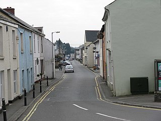
Kelly Bray is a village in east Cornwall, England, United Kingdom. It is situated one mile (1.6 km) north of Callington, immediately west of Kit Hill in a former mining area. Kelly Bray is in the parish of Callington and lies within the St Dominick, Harrowbarrow and Kelly Bray division on Cornwall Council. The population was 3,949 at the 2011 census. Kelly Bray is first recorded ca. 1286 as Kellibregh.

<span class="mw-page-title-main">Chacewater</span> Human settlement in England

Chacewater is a village and civil parish in Cornwall, England, UK. It is situated approximately 3 miles (4.8 km) east of Redruth. The hamlets of Carnhot, Cox Hill, Creegbrawse, Hale Mills, Jolly's Bottom, Salem, Saveock, Scorrier, Todpool, Twelveheads and Wheal Busy are in the parish. The electoral ward is called Chacewater & Kenwyn. At the 2011 census a population of 3,870 was quoted.

<span class="mw-page-title-main">London Apprentice</span> Human settlement in England

London Apprentice is a village in south Cornwall, England, UK, on the banks of St Austell River in the Pentewan Valley approximately two miles (3 km) south of St Austell.

<span class="mw-page-title-main">Calstock</span> Village & Parish in England

Calstock is a civil parish and a large village in south east Cornwall, England, United Kingdom, on the border with Devon. The village is situated on the River Tamar 6 miles (9.7 km) south west of Tavistock and 10 miles (16 km) north of Plymouth.

<span class="mw-page-title-main">St Blazey</span> Town in Cornwall, England

St Blazey is a small town in Cornwall, England, United Kingdom.

<span class="mw-page-title-main">Constantine, Cornwall</span> Human settlement in England

Constantine is a village and civil parish in Cornwall, England, United Kingdom. It is situated approximately five miles (8 km) west-southwest of Falmouth. The electoral ward also bears the same name but includes Budock Water and the surrounding area. At the 2011 census, the population of the ward was 4,709 and the population of the civil parish was 1,789. The parish of Constantine is bounded by the parishes of Mabe, Mawnan, Gweek, Wendron and the north bank of the Helford River.

<span class="mw-page-title-main">The Towans</span>

Towan is found in many placenames in Cornwall. However, The Towans usually refers to the three-mile (5 km) stretch of coastal dunes which extends north-east from the estuary of the River Hayle to Gwithian beach with a midpoint near Upton. The South West Coast Path crosses the towans.

Lanescot is a village in Cornwall, England, United Kingdom. It is in a former mining area, about four miles (6 km) east-northeast of St Austell and four miles (6 km) west-northwest of Fowey. The Saints' Way long-distance footpath passes through Lanescot.

<span class="mw-page-title-main">Caradon Hill</span> Hill on Bodmin Moor in Cornwall, England

Caradon Hill is on Bodmin Moor in the former Caradon district of Cornwall, England, United Kingdom. The summit is 371 metres (1,217 ft) above mean sea level. Caradon Hill is on the southeastern edge of the moor; it is between the villages of Minions (northwest), Upton Cross (northeast), Pensilva (southeast) and Darite (southwest).

<span class="mw-page-title-main">Luxulyan Valley</span> River valley in Cornwall, England

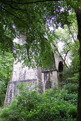
The Luxulyan Valley is the steep sided and thickly wooded valley of the River Par, situated in mid Cornwall, England, UK. It contains a major concentration of early 19th century industrial remains, and was designated as part of a World Heritage Site in 2006.

<span class="mw-page-title-main">Pentewan</span> Human settlement in England

Pentewan is a coastal village and former port in south Cornwall, England, United Kingdom. It is situated at grid reference SX 019 472 3 miles (4.8 km) south of St Austell at the mouth of the St Austell River.

<span class="mw-page-title-main">Troon, Cornwall</span> Human settlement in England

Troon is a village in Cornwall, UK, 1+12 miles southeast of Camborne. The village lies at around 560 feet (170 m) above sea level. An electoral ward named Troon and Beacon covers the area north from Troon to the outskirts of Camborne. The population at the 2011 census was 5,410.

<span class="mw-page-title-main">Sancreed Beacon</span>

Sancreed Beacon is a Bronze Age archaeological site near the village of Sancreed in the Penwith peninsula of Cornwall maintained by the Cornwall Heritage Trust. On top of the hill are several stone cists and Bronze Age archaeological remains comprising burial mounds and the remains of a Bronze Age hut on the Western slope.

Wheal Eliza is a cricket ground in Holmbush, to the east of St Austell, Cornwall. The ground is bordered to the south by Holmbush Road, to the east by the A391 road and to the north and west by housing. The end names of the ground are the City End and the Bethel End. Facilities include two playing fields with their own changing room facilities enabling two competitive matches to be played every match day. The ground also has a pavilion, scorebox, artificial and grass nets.

<span class="mw-page-title-main">Trencrom Hill</span> Hillfort in Cornwall, England

Trencrom Hill is a prominent hill fort, owned by the National Trust, near Lelant, Cornwall. It is crowned by an univallate Neolithic tor enclosure and was re-used as a hillfort in the Iron Age. Cairns or hut circles can be seen in the level area enclosed by the stone and earth banks. The hill overlooks the Hayle Estuary and river, and Mount's Bay and St Michael's Mount can be seen to the south. The hill was recorded as Torcrobm in 1758 which is derived from Cornish "torr crobm", i.e. 'hunched bulge'.

<span class="mw-page-title-main">Rinsey</span> Hamlet in Cornwall, England

Rinsey is a hamlet in Cornwall, England, United Kingdom. It is located off the main A394 road between Helston and Penzance in the civil parish of Breage. The nearby hamlet of Rinsey Croft is located 1 km to the north-east. The nearby cliffs and beach are owned and managed by the National Trust and part of Rinsey East Cliff is designated as the Porthcew Site of Special Scientific Interest (SSSI) for its geological interest. The South West Coast Path passes through the property. Rinsey lies within the Cornwall Area of Outstanding Natural Beauty (AONB).

<span class="mw-page-title-main">Phoenix United Mine</span> Disused copper and tin mine in Cornwall, England

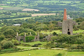
Phoenix United Mine is a disused 19th century copper and tin mine in Cornwall, England, UK. Heavy metals left over in the soil from the mining operations have allowed mosses and lichens to flourish, and today the site is a Site of Special Scientific Interest (SSSI), noted for its biological characteristics.

<span class="mw-page-title-main">Devon Great Consols</span> Former copper mine in Devon, England

Devon Great Consols was a copper mine near Tavistock in Devon. The lease on the site was taken from the Duke of Bedford in 1844 by a group of investors. The 1,024 shares, sold at one pound each, were divided among the six men. Earlier attempts to mine this property had all ended in failure.

References

  1. Ordnance Survey One-inch Map of Great Britain; Bodmin and Launceston, sheet 186. 1961.
  2. Ordnance Survey, 1:2500 map, 1882 (available here Archived 2012-04-30 at the Wayback Machine )
  3. Ordnance Survey, 1:2500 map, 1907
  4. Ordnance Survey, 1:10,560 map, 1962-1963
  5. Ordnance Survey, 1:2500 map, 1970-1971
  6. "Minor Counties Championship Matches played on Wheal Eliza, Bethel, St Austell". CricketArchive. Retrieved 20 July 2014.
  7. Ordnance Survey, 1:2500 map, 2010
  8. "About Boscundle Manor". Boscundle Manor Hotel. Retrieved 20 July 2014.
  9. Historic England. "Boscundle Manor (1210731)". National Heritage List for England . Retrieved 20 July 2014.
  10. "Pinetum Park and Pine Lodge Gardens". Cornwall Tourist Board. Retrieved 20 July 2014.
  11. Hancock 2008, pp. 55–56.
  12. "Charlestown United and Cuddra Consolidated Mines". Mindat.org. Retrieved 20 July 2014.

Bibliography

  • Hancock, Peter (2008). The Mining Heritage of Cornwall and West Devon. Halsgrove. ISBN   978-1-84114-753-6.