Holt, Minnesota

Last updated
Holt
Service station, Holt, Minnesota 8-1-2001.jpg
Service station in Holt
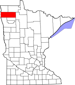
Marshall County Minnesota Incorporated and Unincorporated areas Holt Highlighted.svg
Location of Holt, Minnesota
Coordinates: 48°17′32″N96°11′39″W / 48.29222°N 96.19417°W / 48.29222; -96.19417
CountryUnited States
State Minnesota
County Marshall
Area
[1]
  Total1.00 sq mi (2.59 km2)
  Land1.00 sq mi (2.59 km2)
  Water0.00 sq mi (0.00 km2)
Elevation
1,155 ft (352 m)
Population
 (2020) [2]
  Total90
  Estimate 
(2021) [3]
91
  Density89.82/sq mi (34.68/km2)
Time zone UTC-6 (CST)
  Summer (DST) UTC-5 (CDT)
ZIP code
56738
Area code 218
FIPS code 27-29870
GNIS feature ID0645106 [4]

Holt is a city in Marshall County, Minnesota, United States. The population was 90 at the 2020 census. [2]

Contents

Geography

According to the United States Census Bureau, the city has a total area of 1.01 square miles (2.62 km2), all land. [5]

Demographics

Historical population
CensusPop.Note
1920 232
1930 193−16.8%
1940 2098.3%
1950 172−17.7%
1960 114−33.7%
1970 97−14.9%
1980 11922.7%
1990 88−26.1%
2000 891.1%
2010 88−1.1%
2020 902.3%
2021 (est.)91 [3] 1.1%
U.S. Decennial Census [6]
2020 Census [2]

2010 census

As of the census of 2010, there were 88 people, 36 households, and 25 families living in the city. The population density was 87.1 inhabitants per square mile (33.6/km2). There were 38 housing units at an average density of 37.6 per square mile (14.5/km2). The racial makeup of the city was 93.2% White, 1.1% African American, 4.5% Native American, and 1.1% from two or more races. Hispanic or Latino of any race were 1.1% of the population.

There were 36 households, of which 33.3% had children under the age of 18 living with them, 61.1% were married couples living together, 5.6% had a female householder with no husband present, 2.8% had a male householder with no wife present, and 30.6% were non-families. 25.0% of all households were made up of individuals, and 11.1% had someone living alone who was 65 years of age or older. The average household size was 2.44 and the average family size was 3.00.

The median age in the city was 37.7 years. 27.3% of residents were under the age of 18; 1.1% were between the ages of 18 and 24; 31.9% were from 25 to 44; 28.4% were from 45 to 64; and 11.4% were 65 years of age or older. The gender makeup of the city was 53.4% male and 46.6% female.

2000 census

As of the census of 2000, there were 89 people, 36 households, and 25 families living in the city. The population density was 88.2 inhabitants per square mile (34.1/km2). There were 41 housing units at an average density of 40.6 per square mile (15.7/km2). The racial makeup of the city was 97.75% White, 1.12% Native American and 1.12% Asian.

There were 36 households, out of which 27.8% had children under the age of 18 living with them, 72.2% were married couples living together, and 27.8% were non-families. 22.2% of all households were made up of individuals, and 2.8% had someone living alone who was 65 years of age or older. The average household size was 2.47 and the average family size was 2.92.

In the city, the population was spread out, with 16.9% under the age of 18, 21.3% from 18 to 24, 33.7% from 25 to 44, 20.2% from 45 to 64, and 7.9% who were 65 years of age or older. The median age was 34 years. For every 100 females, there were 140.5 males. For every 100 females age 18 and over, there were 146.7 males.

The median income for a household in the city was $32,500, and the median income for a family was $36,250. Males had a median income of $22,188 versus $16,250 for females. The per capita income for the city was $14,796. There were 13.0% of families and 8.8% of the population living below the poverty line, including no under eighteens and 50.0% of those over 64.

Related Research Articles

<span class="mw-page-title-main">Osgood, Indiana</span> Town in Indiana, United States

Osgood is a town in Center Township, Ripley County, in the U.S. state of Indiana. The population was 1,624 at the 2010 census.

<span class="mw-page-title-main">Minden, Iowa</span> City in Iowa, United States

Minden is a city in Pottawattamie County, Iowa, United States. The population was 600 at the time of the 2020 census. It has possessed a post office since 1875.

<span class="mw-page-title-main">Dixon, Iowa</span> City in Iowa, USA

Dixon is a city in Scott County, Iowa, United States. The population was 202 at the time of the 2020 census.

Lafayette Township is a civil township of Gratiot County in the U.S. state of Michigan. The population was 656 at the 2000 census.

<span class="mw-page-title-main">Clam Union Township, Michigan</span> Civil township in Michigan, United States

Clam Union Township is a civil township of Missaukee County in the U.S. state of Michigan. The population was 882 at the 2010 census.

<span class="mw-page-title-main">Garfield, Minnesota</span> City in Minnesota, United States

Garfield is a city in Douglas County, Minnesota, United States. The population was 349 at the 2020 census.

<span class="mw-page-title-main">Halma, Minnesota</span> City in Minnesota, United States

Halma is a city in Kittson County, Minnesota, United States. The population was 58 at the 2020 census.

<span class="mw-page-title-main">Trail, Minnesota</span> City in Minnesota, United States

Trail is a city in Polk County, Minnesota, United States. It is part of the Grand Forks, ND-MN Metropolitan Statistical Area. The population was 40 at the 2020 census.

<span class="mw-page-title-main">Greenwald, Minnesota</span> City in Minnesota, United States

Greenwald is a city in Stearns County, Minnesota, United States. The population was 222 at the 2010 census. It is part of the St. Cloud Metropolitan Statistical Area.

<span class="mw-page-title-main">Huntley, Nebraska</span> Village in Nebraska, United States

Huntley is a village in Harlan County, Nebraska, United States. The population was 44 at the 2010 census.

<span class="mw-page-title-main">Italy, New York</span> Town in New York, United States

Italy is a town located in Yates County, New York, United States. As of the 2010 census, the town had a total population of 1,141. The town takes its name from the country of Italy.

Light Oak is an unincorporated area and census-designated place (CDP) in Cleveland County, North Carolina, United States. The population was 691 at the 2010 census.

<span class="mw-page-title-main">Knox, North Dakota</span> City in North Dakota, United States

Knox is a city in Benson County, North Dakota, United States. The population was 22 at the 2020 census. Knox was founded in 1887.

<span class="mw-page-title-main">Arthur, North Dakota</span> City in North Dakota, United States

Arthur is a city in Cass County, North Dakota, United States. The population was 328 at the 2020 census.

<span class="mw-page-title-main">Onaka, South Dakota</span> Town in South Dakota, United States

Onaka is a town in Faulk County, South Dakota, United States. The population was 13 at the 2020 census.

<span class="mw-page-title-main">St. Anthony, Stearns County, Minnesota</span> City in Minnesota, United States

St. Anthony is a city in Stearns County, Minnesota, United States. The population was 86 at the 2010 census. It is part of the St. Cloud Metropolitan Statistical Area. Main routes include Minnesota State Highway 238, Stearns County Road 153, and Trobec Street.

<span class="mw-page-title-main">Stonewood, West Virginia</span> City in West Virginia, United States

Stonewood is a city in Harrison County, West Virginia, United States. The population was 1,810 at the 2020 census.

<span class="mw-page-title-main">Bell Center, Wisconsin</span> Village in Wisconsin, United States

Bell Center is a village in Crawford County, Wisconsin, United States. The population was 117 at the 2010 census.

<span class="mw-page-title-main">Falcon, North Carolina</span> Town in North Carolina, United States

Falcon is a town in Cumberland and Sampson counties in the U.S. state of North Carolina. The population was 258 at the 2010 census.

<span class="mw-page-title-main">Spring Hill, Indiana</span> Town in Indiana, United States

Spring Hill is a town in Marion County, Indiana, United States. The population was 95 at the 2020 census. It has existed as an "included town" since 1970, when it was incorporated into Indianapolis as part of Unigov. It is part of Indianapolis, but retains town governmental powers under IC 36-3-1-11.

References

  1. "2020 U.S. Gazetteer Files". United States Census Bureau. Retrieved July 24, 2022.
  2. 1 2 3 "Explore Census Data". United States Census Bureau . Retrieved May 19, 2022.
  3. 1 2 "City and Town Population Totals: 2020-2021". United States Census Bureau. June 25, 2022. Retrieved June 25, 2022.
  4. "US Board on Geographic Names". United States Geological Survey. October 25, 2007. Retrieved January 31, 2008.
  5. "US Gazetteer files 2010". United States Census Bureau. Archived from the original on January 25, 2012. Retrieved November 13, 2012.
  6. United States Census Bureau. "Census of Population and Housing" . Retrieved June 9, 2014.

Coordinates: 48°17′31″N96°11′33″W / 48.29194°N 96.19250°W / 48.29194; -96.19250