
Meramec State Park is a public recreation area located near Sullivan, Missouri, about 60 miles from St. Louis, along the Meramec River. The park has diverse ecosystems such as hardwood forests and glades. There are over 40 caves located throughout the park, the bedrock is dolomite. The most famous is Fisher Cave, located near the campgrounds. The park borders the Meramec Conservation Area.

Watoga State Park is a state park located near Seebert in Pocahontas County, West Virginia. The largest of West Virginia's state parks, it covers slightly over 10,100 acres (41 km2). Nearby parks include the Greenbrier River Trail, which is adjacent to the park, Beartown State Park, and Droop Mountain Battlefield State Park. Also immediately adjacent to the park is the 9,482-acre Calvin Price State Forest. It is one of the darkest night skies of all of West Virginia State Parks.

Backbone State Park is Iowa's oldest state park, dedicated in 1919. Located in the valley of the Maquoketa River, it is approximately three miles (5 km) south of Strawberry Point in Delaware County. It is named for a narrow and steep ridge of bedrock carved by a loop of the Maquoketa River originally known as the Devil's Backbone. The initial 1,200 acres (490 ha) were donated by E.M. Carr of Lamont, Iowa. Backbone Lake Dam, a relatively low dam built by the Civilian Conservation Corps (CCC) in the 1930s, created Backbone Lake. The CCC constructed a majority of trails and buildings which make up the park.

Senator Stephen Benton Elkins House, also known as Halliehurst, is an historic mansion located at Elkins, Randolph County, West Virginia. It was designed by architect Charles T. Mott and built in 1890, as a summer home for U.S. Senator Stephen Benton Elkins. It consists of a three-story main block with hipped roof and service wing. The roof is punctuated by towers, turrets, dormers, and chimneys. A porch surrounds much of the first floor. It features a two-story portico with columns around a central, flat roofed tower. Located on a mountainside, it commands a view of the valley beneath and the forest and mountain peaks that surround the valley. In 1923, the house and approximately 60 acres of land were deeded to Davis & Elkins College by Sen. Elkins' widow.

The Black Moshannon State Park Historic Districts are three separate historic districts on the National Register of Historic Places (NRHP) at Black Moshannon State Park in Rush Township, Centre County, Pennsylvania in the United States. The structures in the historic districts were constructed in the 1930s during the Great Depression by the Civilian Conservation Corps (CCC). The three districts are: the Beach and Day Use District, with 18 contributing structures, including 11 different picnic pavilions, concession building, bathhouse, museum, and four open pit latrines; the Family Cabin District with 16 contributing properties, including 13 cabins, one lodge and two latrines; and the Maintenance District with four contributing properties, including a storage building, three-bay garage, gas pump house, and ranger's residence.

The Toll House is a historic toll house at 2028 Mountain Road in Burke, Vermont. It was built in 1940-41 by crews of the Civilian Conservation Corps as an administrative headquarters for Darling State Park, and as a toll house for the Burke Mountain Road. It is one of the state's finest examples of CCC architecture. It was listed on the National Register of Historic Places in 2006.

The Unity Ranger Station is a United States Forest Service compound consisting of five buildings and a lookout tower in the Wallowa-Whitman National Forest of northeastern Oregon. It was previously the administrative headquarters for the Unity Ranger District. It is located in the small unincorporated community of Unity, Oregon. The historic structures were built in the rustic style by the Civilian Conservation Corps between 1936 and 1938. Today, the ranger station is only used during the summer months to house Forest Service fire crews. The ranger station is listed on the National Register of Historic Places.

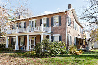
Avery House, in Griswold, Connecticut, also known as Hopeville Pond Park House, was built around 1770. The house is a 20 feet (6.1 m) by 40 feet (12 m), the two-story central-chimney Colonial that was originally sheathed in clapboard and topped with a gable roof. The central chimney is on a stone base and has a built-in root cellar. Alterations in the house changed the traditional five-room first floor plan by eliminating the keeping rooms and the removal of the kitchen fireplace. It retains much of its original door frames and wrought-iron latch hardware. After the rehabilitation of the property, the Avery House became the Hopeville Park manager's residence and is a part of the Hopeville Pond State Park. It was listed on the National Register of Historic Places in 1986.
Blue Bend Forest Camp, also known as Blue Bend Recreation Area, is a historic recreational area near Alvon, West Virginia. The site was planned and developed by the Civilian Conservation Corps from 1936 to 1938 and is one of four CCC-built recreational areas in Monongahela National Forest. Anthony Creek runs through the camp, and a pool on the creek known as Blue Hole is a fishing area and one of the main features of the site. Blue Bend Forest Camp also includes log picnic shelters and twenty-one campsites. The camp was added to the National Register of Historic Places on April 20, 1994.

The David L. Shirk Ranch is a historic ranch located in the Guano Valley of eastern Lake County, Oregon, United States. The ranch was originally homesteaded in 1881. It was purchased by David L. Shirk in 1883. He operated the ranch until 1914. The property was acquired by the United States Government in 1942. The ranch is now administered by the Bureau of Land Management. The remaining historic ranch buildings are listed on the National Register of Historic Places.

The American Legion Forest CCC Shelter is a historic rustic log shelter, located on the west side of West River Road within the American Legion State Forest in Barkhamsted, Connecticut. It is the only surviving one of four such structures in the area built by the Civilian Conservation Corps (CCC), and one of only two CCC-built shelters to survive in the state. The shelter was listed on the National Register of Historic Places in 1986.

Canelo Ranger Station, also known as Canelo Work Station, is a historic ranger station in the Coronado National Forest, within Santa Cruz County of southern Arizona. It is located in the ghost town of Canelo, within a small valley between the Canelo Hills on the west and the northern Huachuca Mountains on the east.
Fort Hill, also known as Fort Hill Farm, is a historic plantation house and national historic district located near Burlington, Mineral County, West Virginia. The district includes 15 contributing buildings, 1 contributing site, and 2 contributing structures. The main house was completed in 1853, and is a two-story, "L"-shaped brick dwelling composed of a side gable roofed, five bay building with a rear extension in the Federal style. It features a three-bay, one-story front porch supported by four one foot square Tuscan order columns. Also on the property are a number of contributing buildings including a washhouse and cellar, outhouse, a dairy and ice house, a meat house, a garage, a hog house, poultry houses, a bank barn with silo, and a well. The family cemetery is across the road west of the main house. Located nearby and in the district is "Woodside," a schoolhouse built about 1890, and a tenant house and summer kitchen.

"Edemar", also known as Stifel Fine Arts Center, is a historic house and national historic district located at Wheeling, Ohio County, West Virginia. The district includes two contributing buildings and two contributing structures. The main house was built between 1910 and 1914, and is a 2+1⁄2-story, brick-and-concrete Classical Revival mansion with a steel frame. The front facade features a full-width portico with pediment supported by six Corinthian order columns. Also on the property are a contributing brick, tiled-roofed three-bay carriage barn/garage; fish pond; and formal garden. The Stifel family occupied the home until 1976, when the family gave it to the Oglebay Institute to be used as the Stifel Fine Arts Center.

The Gasquet Ranger Station Historic District comprises a compound of buildings associated with the Gasquet Ranger District of Six Rivers National Forest. The U.S. Forest Service complex is located along the Smith River on U.S. Route 199 in Del Norte County, California, within Smith River National Recreation Area. Most of the buildings were built by the Civilian Conservation Corps between 1933 and 1939. Seven buildings and a rock wall remain of the CCC-built structures. The district office, the assistant district ranger's residence, a warehouse, two garages and a fuel house were built in the Forest Service rustic style that prevailed at the time. The style is reflected in distinctive detailing, including a recurring pine tree cut-out logo that appears on gables and shutters.

The District No. 9 Schoolhouse is a historic school building at 358 Hoyt Road in Gilford, New Hampshire. Built in 1815 and repeatedly altered to accommodated changing trends in school design, it is the best-preserved of Gilford's surviving district schoolhouses. Now a private summer residence, the building was listed on the National Register of Historic Places in 2000.

Townshend State Park is a state park in Townshend, Vermont. Embedded within Townshend State Forest, the park provides a camping facility and hiking trails for accessing Bald Mountain. The park's facilities were developed by the Civilian Conservation Corps in the 1930s, and are listed on the National Register of Historic Places for their well-preserved state.

Pilot Knob State Park is located southeast of Forest City, Iowa, United States. Founded in 1923, it is one of the oldest state parks in Iowa. Between 1990 and 1995 one area was named nationally recognized historic district and five structures were individually listed on the National Register of Historic Places.

Lacey-Keosauqua State Park is located southwest of Keosauqua, Iowa, United States. The park is located along the Des Moines River in Van Buren County. First dedicated in 1921, it is the largest state park in size in Iowa. In 1990, three areas were named nationally recognized historic districts and listed on the National Register of Historic Places.
The Stowe CCC Side Camp, now known as the Vermont State Ski Dorm, is a historic residence hall at 6992 Mountain Road in Stowe, Vermont. Built in 1935 by crews of the Civilian Conservation Corps, it is one of the largest surviving CCC-built housing units to survive in the state. It was converted for use as a ski lodge after World War II. It was listed on the National Register of Historic Places in 2002.

