Coahoma County is a county located in the U.S. state of Mississippi. As of the 2010 census, the population was 26,151. Its county seat is Clarksdale.

Clarksdale is a city in and the county seat of Coahoma County, Mississippi, United States. It is located along the Sunflower River. Clarksdale is named after John Clark, a settler who founded the city in the mid-19th century when he established a timber mill and business.

Friars Point is a town in Coahoma County, Mississippi, United States. The population was 1,200 at the 2010 census, down from 1,480 in 2000.

Jonestown is a town in Coahoma County, Mississippi, United States. The population was 1,298 as of the 2010 census, down from 1,701 in 2000.

Lula is a town in Coahoma County, Mississippi, United States. The population was 298 at the 2010 census, down from 370 in 2000.

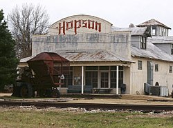
Dublin, also known as Hopson Bayou, is an unincorporated community located along U.S. Route 49 in southeastern Coahoma County, Mississippi, United States. Dublin is located on the Mississippi Delta Railroad. Dublin has a ZIP code of 38739. A post office first began operation under the name Dublin in 1875.

Bobo is an unincorporated community in Coahoma County, Mississippi, United States. Bobo is located on U.S. routes 61 and 278, southwest of Clarksdale.
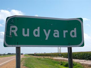
Rudyard is an unincorporated community located near U.S. Route 61 in Coahoma County, Mississippi, United States. Rudyard is 10 miles north of Clarksdale and two miles south of Coahoma along Old Highway 61 and is located on the former Yazoo and Mississippi Valley Railroad. A post office operated under the name Hillhouse from 1899 to 1956.
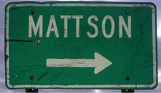
Mattson, also known as Earnest, is an unincorporated community located near U.S. Route 49 in Coahoma County, Mississippi, United States.

Sherard is an unincorporated community located in Coahoma County, Mississippi, United States. Sherard is located along Mississippi Highway 1, 6 miles (9.7 km) west of Clarksdale.
Stovall, also known as Prarieville, is an unincorporated community in Coahoma County, Mississippi, United States, along Mississippi Highway 1, 7 miles (11 km) north of Sherard and approximately 6 miles (9.7 km) south of Friars Point.
Clover Hill is an unincorporated community located in Coahoma County, Mississippi, United States. Clover Hill is approximately 4 miles (6.4 km) north of Lyon and approximately 4 miles (6.4 km) south of Rudyard. The community is located on the former plantation of J. T. Fargason. Clover Hill once had a depot on the former Yazoo and Mississippi Valley Railroad. A post office operated under the name Clover Hill from 1884 to 1935.
Claremont, also known as Rose, is an unincorporated community located in Coahoma County, Mississippi, United States. Claremont is approximately 2 miles (3.2 km) north of Mattson and approximately 4 miles (6.4 km) south of Clarksdale. Claremont is located on the former Yazoo and Mississippi Valley Railroad. A post office operated under the name Rose from 1904 to 1905 and under the name Claremont from 1905 to 1932.
The Mississippi Delta Railroad is a shortline railroad company operating from Swan Lake to Jonestown, Mississippi, a distance of 60 miles (97 km); the railroad interchanges with the Illinois Central at Swan Lake. Currently the railroad is owned by Coahoma County and was a former subsidiary of Gulf and Ohio Railways shortline group. The current operator is Rock Island Rail.
Eagles Nest is an unincorporated community located in Coahoma County, Mississippi, United States. Eagles Nest is approximately 2 miles (3.2 km) south of Jonestown and approximately 11 miles (18 km) west of Belen. Eagles Nest is named for the former plantation of James L. Alcorn, which in turn received its name from an eagle's nest that was built near the site. The community is located on the former Louisville, New Orleans and Texas Railway. A post office operated under the name Eagles Nest from 1887 to 1909.
Roundaway is an unincorporated community located in Coahoma County, Mississippi, United States. Roundaway is approximately 14 miles (23 km) south of Clarksdale and 2 miles (3.2 km) north of Baltzer on New Africa Road. Roundaway is located on the former Yazoo and Mississippi Valley Railroad. A public school was once operated in Roundaway. A post office operated under the name Roundaway from 1905 to 1935.
Clarksdale High School (CHS) is the public high school of Clarksdale, Mississippi and a part of the Clarksdale Municipal School District.
Mississippi Highway 161 (MS 161) is a state highway designation for three highways in the U.S. state of Mississippi, consisting of old alignments of U.S. Route 61 (US 61). Totaling at 19.872 miles (31.981 km), the three sections are located in Bolivar, Coahoma, and Desoto counties. The Bolivar County section, designated in 2000, travels from Merigold to Mound Bayou and Shelby. In Coahoma County, MS 161 was designated in 2004 and runs through Clarksdale and Lyon. In Desoto County, MS 161 travels through the town of Walls and was created in 1999.
Sunflower Landing is an unincorporated community in Coahoma County, Mississippi, United States.

The New Alcazar Hotel also known as Alcazar Hotel is a historic building in Clarksdale, Mississippi. Once considered one of the premier hotels in the South, the Alcazar Hotel hosted guest such as playwright Tennessee Williams. Located in the hotel was a restaurant and several other businesses, including WROX radio station which broadcast from the hotel for 40 years.