A county seat is an administrative center, seat of government, or capital city of a county or civil parish. The term is used in Canada, China, Hungary, Romania, and the United States. The equivalent term shire town is used in the U.S. state of Vermont and in some other English-speaking jurisdictions. County towns have a similar function in the United Kingdom and Republic of Ireland, as well as historically in Jamaica.

Radford is an independent city in the U.S. state of Virginia. As of 2010, the population was 16,408 by the United States Census Bureau. For statistical purposes, the Bureau of Economic Analysis combines the city of Radford with neighboring Montgomery County.
Interstate 59 (I-59) is an Interstate Highway located in the southeastern United States. It is a north–south route that spans 445.23 miles (716.53 km) from a junction with I-10 and I-12 at Slidell, Louisiana, to a junction with I-24 near Wildwood, Georgia.

Cape May County is the southernmost county in the U.S. state of New Jersey. Much of the county is located on the Cape May Peninsula, bounded by the Delaware Bay to the west, and the Atlantic Ocean to the south and east. Adjacent to the Atlantic coastline are five barrier islands that have been built up as seaside resorts. A consistently popular summer destination with 30 miles (48 km) of beaches, Cape May County attracts vacationers from New Jersey and surrounding states, with the summer population exceeding 750,000. Tourism generates annual revenues of about $6.6 billion as of 2018, making it the county's single largest industry, with leisure and hospitality being Cape May's largest employment category. Its county seat is the Cape May Court House section of Middle Township.

Coahoma County is a county located in the U.S. state of Mississippi. As of the 2010 census, the population was 26,151. Its county seat is Clarksdale.
Route 47 is a state highway in the southern part of New Jersey, United States. It runs 75.20 mi (121.02 km) from Atlantic Avenue in Wildwood, Cape May County north to U.S. Route 130 in Brooklawn, Camden County. It is also referred to as Delsea Drive, as it connects the Delaware River near Brooklawn to the Atlantic Ocean in Wildwood. This name was assigned by the New Jersey Legislature in 1933. The route runs through rural areas of Cape May and southern Cumberland counties as a two-lane road. Traffic jams along this portion of Route 47 are commonplace in the summer vacation season and can stretch for miles due to the missing southern section of Route 55, where all Jersey Shore-bound traffic enters the small two-lane road. North of here, the route runs through the cities of Millville and Vineland before entering Gloucester County, where it passes through more rural areas as well as Clayton and Glassboro. Past Glassboro, it heads through suburban areas in Washington and Deptford townships before running through Westville and Brooklawn. Route 47 is the longest signed state route in New Jersey.

Wildwood is a city in St. Louis County, Missouri, United States. It is located in the far western portion of the county. As of the 2010 census, the population was 35,517. Wildwood is the home of the Al Foster Trail, and numerous other trails, parks, and reserves such as Rockwoods Reservation and Babler State Park.

North Wildwood is a city located on the Jersey Shore in Cape May County, New Jersey, United States. It is part of the Ocean City Metropolitan Statistical Area. As of the 2010 United States Census, the city's population was 4,041, reflecting a decline of 894 (-18.1%) from the 4,935 counted in the 2000 Census, which had in turn declined by 82 (-1.6%) from the 5,017 counted in the 1990 Census. North Wildwood is home to the Hereford Inlet Lighthouse.

West Wildwood is a borough in Cape May County, New Jersey, United States. It is part of the Ocean City Metropolitan Statistical Area. As of the 2010 United States Census, the borough's population was 603, reflecting an increase of 155 (+34.6%) from the 448 counted in the 2000 Census, which had in turn declined by 5 (-1.1%) from the 453 counted in the 1990 Census. The summer population grows to as much as 5,000.

Wildwood is a city in Cape May County, New Jersey, United States. It is part of the Ocean City Metropolitan Statistical Area and is a popular summer resort destination along the Jersey Shore. As of the 2010 United States Census, the city's year-round population was 5,325, reflecting a decline of 111 (-2.0%) from the 5,436 counted in the 2000 Census, which had in turn increased by 952 (+21.2%) from the 4,484 counted in the 1990 Census. With visitors, the population can swell to 250,000 during the summer months. Wildwood was the first city in New Jersey to have a female mayor, Doris W. Bradway, who was ousted in a 1938 recall election.
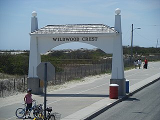
Wildwood Crest is a borough in Cape May County, New Jersey, United States. It is part of the Ocean City Metropolitan Statistical Area. As of the 2010 United States Census, the borough's population was 3,270, reflecting a decline of 710 (−17.8%) from the 3,980 counted in the 2000 Census, which had in turn increased by 349 (+9.6%) from the 3,631 counted in the 1990 Census.
Route 147 is a 4.20-mile (6.76 km) state highway located in Cape May County in New Jersey, United States. It is a short connector between U.S. Route 9 in Middle Township and North Wildwood at New York Avenue. West of U.S. Route 9, the road continues to Route 47 as County Route 618 ; this route along with Route 147 provides an alternate route to The Wildwoods from Route 47. East of New York Avenue, the route continues south through The Wildwoods as County Route 621. The route passes through mostly marshland along its journey, intersecting the Garden State Parkway at a partial interchange and County Route 619.

The Jersey Shore is the coastal region of the U.S. state of New Jersey. Geographically, the term encompasses about 141 miles (227 km) of oceanfront bordering the Atlantic Ocean, from Perth Amboy in the north to Cape May Point in the south. The region includes Middlesex, Monmouth, Ocean, Atlantic, and Cape May counties, which are in the central and southern parts of the state. The Jersey Shore hosts the highest concentration of oceanside boardwalks in the United States.

Cape May is a peninsula and island ; the southern tip of the island is the southernmost point of the U.S. state of New Jersey. The peninsula resides in Cape May County and runs southwards from the New Jersey mainland, separating Delaware Bay from the Atlantic Ocean. The cape is named for Cornelius Jacobsen Mey, a Dutch explorer who worked for the Dutch East India Company.

Forest Glen is one of the 77 official city community areas of Chicago, Illinois, located on the city's Northwest Side. It comprises the neighborhoods of Forest Glen, Edgebrook and Sauganash, with sub-neighborhoods of Sauganash Park, Wildwood, North Edgebrook and Old Edgebrook.

Wildwood State Park is a 767-acre (3.10 km2) state park located in Suffolk County, New York. The park is in the Town of Riverhead on the north shore of Long Island. The park includes a beach on Long Island Sound.

Lake Louise State Park is a Minnesota state park just north of the Iowa border near the small town of Le Roy in Mower County, Minnesota, directly south of Rochester. It has a 25 acre man-made lake and 1,168 acres (5 km2) of mixed prairie and deciduous forest. It is used for picnics, swimming, camping, hiking, horseback riding, and other outdoor recreation. It is noted for butterfly watching, as some rare species have been seen. It features a picnic shelter which dates to the Public Works Administration era.
Glencoe was an unincorporated community in western St. Louis County, Missouri, United States. It is located on the west side of the Meramec River, north of Eureka in the southern part of Wildwood and is just off Route 109.
Wildwood, North Carolina is a small unincorporated community centered on the Wildwood Road, just west of the Morehead City, North Carolina town limits along US Highway 70, in Carteret County, North Carolina. Newport, North Carolina is the next closest town.

Wildwood is an unincorporated community located in Leflore County, Mississippi. Wildwood is approximately 4 miles (6.4 km) south of Money on County Road 626.

