
Coahoma County is a county located in the U.S. state of Mississippi. As of the 2020 census, the population was 21,390. Its county seat is Clarksdale.

Bolivar County is a county located on the western border of the U.S. state of Mississippi. As of the 2020 census, the population was 30,985. Its county seats are Rosedale and Cleveland. The county is named in honor of Simón Bolívar, early 19th-century leader of the liberation of several South American colonies from Spain.

Clarksdale is a city in and the county seat of Coahoma County, Mississippi, United States. It is located along the Sunflower River. Clarksdale is named after John Clark, a settler who founded the city in the mid-19th century when he established a timber mill and business.
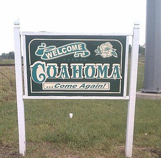
Coahoma is a town in Coahoma County, Mississippi, United States. Per the 2020 census, the population was 229.

Minter City is an unincorporated community in Leflore County and Tallahatchie County, Mississippi. It is part of the Greenwood, Mississippi micropolitan area, and is within the Mississippi Delta.
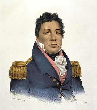
Pushmataha, the "Indian General", was one of the three regional chiefs of the major divisions of the Choctaw in the 19th century. Many historians considered him the "greatest of all Choctaw chiefs". Pushmataha was highly regarded among Native Americans, Europeans, and white Americans, for his skill and cunning in both war and diplomacy.
The Coahoma County School District (CCSD) is a public school district with its administrative headquarters in Clarksdale, Mississippi (USA).
Coahoma Early College High School (CECHS), formerly Coahoma Agricultural High School (CAHS), is a public secondary school in unincorporated Coahoma County, Mississippi, with a Clarksdale postal address. The school is designated as a part of the Coahoma Agricultural High School District, and operated by Coahoma Community College. Previously it was, as of 2000, one of three independently functioning agricultural high schools in the state of Mississippi. The school has its own facilities, instructional and administrative personnel, and student programs. It shares library facilities with the college.
Coahoma Community College (CCC) is a public historically black community college in Coahoma County, Mississippi. The college was founded in 1949 and is accredited by the Southern Association of Colleges and Schools Commission on Colleges. It offers associate degree and certificate programs in more than 70 areas of focus.

The Pushmataha Area Council is part of the Boy Scouts of America. It renders service to Scout units in ten counties of North Mississippi, providing skills training and character development to boys and girls between the ages of 5 and 18. The council also serves boys and girls between the ages of 14 and 21 through Venturing Crews and Explorer posts.

Vance is an unincorporated community in Quitman and Tallahatchie counties, Mississippi. Vance is located on Mississippi Highway 3 northeast of Tutwiler. Vance has a post office with ZIP code 38964.
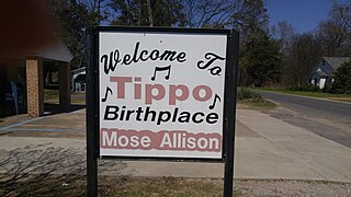
Tippo is an unincorporated community located in Tallahatchie County, Mississippi, United States, located approximately 10 miles (16 km) from Swan Lake; 11 miles (18 km) northeast of Glendora; and approximately 14 miles (23 km) from Charleston. Tippo is located at the intersection of Tippo and Sharkey roads.
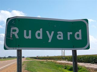
Rudyard is an unincorporated community located near U.S. Route 61 in Coahoma County, Mississippi, United States. Rudyard is 10 miles north of Clarksdale and two miles south of Coahoma along Old Highway 61 and is located on the former Yazoo and Mississippi Valley Railroad. A post office operated under the name Hillhouse from 1899 to 1956.

Sherard is an unincorporated community located in Coahoma County, Mississippi, United States. Sherard is located along Mississippi Highway 1, 6 miles (9.7 km) west of Clarksdale.
Roundaway is an unincorporated community located in Coahoma County, Mississippi, United States. Roundaway is approximately 14 miles (23 km) south of Clarksdale and 2 miles (3.2 km) north of Baltzer on New Africa Road. Roundaway is located on the former Yazoo and Mississippi Valley Railroad. A public school was once operated in Roundaway. A post office operated under the name Roundaway from 1905 to 1935.

Hopson is an unincorporated community located in Coahoma County, Mississippi, United States, south of Clarksdale and U.S. Route 61 along U.S. Route 49. Hopson is located on the former Yazoo and Mississippi Valley Railroad. A post office operated under the name Hopson from 1857 to 1867. In 1944 The Hopson Planting Company used International Harvester cotton pickers to harvest cotton, becoming the first farm to mechanically cultivate and produce an entire cotton crop. The former Hopson Plantation Company Store is now operated as a restaurant and music venue.
Port Royal is a ghost town in Coahoma County, Mississippi, United States.
Delta is a ghost town in Coahoma County, Mississippi, United States.
Burke Landing is an unincorporated community located on the Mississippi River in Coahoma County, Mississippi, United States.
Sunflower Landing is an unincorporated community in Coahoma County, Mississippi, United States.


