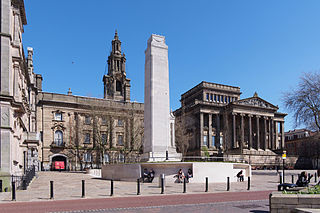
Preston is a city on the north bank of the River Ribble in Lancashire, England. The city is the administrative centre of the county of Lancashire and the wider City of Preston local government district. Preston and its surrounding district obtained city status in 2002, becoming England's 50th city in the 50th year of Queen Elizabeth II's reign. Preston has a population of 114,300, the City of Preston district 132,000 and the Preston Built-up Area 313,322. The Preston Travel To Work Area, in 2011, had a population of 420,661, compared with 354,000 in the previous census. The south bank of the Ribble is part of the Preston urban area, although it forms the South Ribble borough that is administratively separate.

South Ribble is a local government district with borough status in Lancashire, England. Its council is based in Leyland. The borough also includes the towns and villages of Penwortham, Leyland, Farington, Hutton, Longton, Walmer Bridge, Salmesbury, Lostock Hall, Walton le Dale and Bamber Bridge. Many of the built-up areas in the borough form part of the wider Preston built-up area.

Standish is a town in the Metropolitan Borough of Wigan, Greater Manchester, England. Within the boundaries of the historic county of Lancashire, it is on the A49 road between Chorley and Wigan, near Junction 27 of the M6 motorway. The population of the town was 13,278 in the 2011 census.

South Ribble is a constituency represented in the House of Commons of the UK Parliament since 2024 by Paul Foster for Labour.

Longton is a village and civil parish in the west of the borough of South Ribble, Lancashire, England. It is about 4 miles to the south west of Preston. The population of the civil parish, which also includes the village of New Longton, was 5,500 at the 2001 Census increasing to 7,652 at the 2011 Census.
The West Lancashire Railway (WLR) ran northeast from Southport to Preston in northwest England.

Penwortham is a town and civil parish in South Ribble, Lancashire, England, on the south bank of the River Ribble facing the city of Preston. The town is at the most westerly crossing point of the river, with major road and rail links crossing it here. The population of the town at the 2011 census was 23,047.

Bretherton is a small village and civil parish in the Borough of Chorley, Lancashire, England, situated to the south west of Leyland and east of Tarleton. The population of the civil parish at the 2011 census was 669. Its name suggests pre-conquest origins and its early history was closely involved with the manor house Bank Hall and the families who lived there. Bretherton remained a rural community and today is largely residential with residents commuting to nearby towns.
Preston was a rural district in Lancashire, England from 1894 to 1974. It surrounded Preston to the north, west and east.

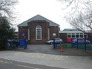
Hutton Grammar School is an 11–18 boys voluntary aided, state-funded Church of England comprehensive day school. It is located 3 miles (4.8 km) south west of Preston, Lancashire, in Hutton, England. It provides education for boys from the age of 11 to 16, and in the Sixth Form for both boys and girls.
New Longton and Hutton station was a railway station on the West Lancashire Railway in England. It was over a mile from each of the villages of Hutton and Howick Cross.
Longton Bridge was a railway station on the West Lancashire Railway in England. It served the village of Longton.

New Longton is a village located 4 miles (6 km) south west of Preston, in the district of South Ribble, in the county of Lancashire, North West England. It is in the parish of Longton, which is the name of the older village located 2 miles (3 km) to the west of New Longton.

Newton-with-Scales is a village and former civil parish, now in the parish of Newton-with-Clifton, in the Fylde district, in the county of Lancashire, England. It is situated on the A583 road, 5 miles (8 km) from Preston and 11 miles (18 km) from Blackpool, in the. It has a park situated on School Lane, a restaurant / pub called the Bell and Bottle, a primary school called Newton Bluecoats, a shop called The convenience store which also has a Post Office. On the main road out of the village you will also find a Petrol Station and an Indian Restaurant called Ali Raj.
Hutton is a village and civil parish in Lancashire, England. It is located 3 miles (4.8 km) south west of Preston, in the South Ribble borough and parliamentary constituency. The population of the civil parish at the 2011 census was 2,277.
Little Hoole is a civil parish in Lancashire, England, It contains the village of Walmer Bridge, and the remaining part is predominantly a farming community. Other nearby villages include Much Hoole and Longton. The parish had a population of 1,815 people in 2001, increasing to 2,070 at the 2011 Census.
Penwortham is a civil parish in the South Ribble district of Lancashire, England. It contains 12 buildings that are recorded in the National Heritage List for England as designated listed buildings. Of these, one is listed at Grade II*, the middle grade, and the others are at Grade II, the lowest grade. The parish contains the town of Penwortham and surrounding countryside. The listed buildings include a medieval wayside cross, a church and structures in the churchyard, houses of varying dates, an inn, and a railway viaduct carrying the West Coast Main Line over the River Ribble.


