
The following is an alphabetical list of articles related to the Commonwealth of Puerto Rico .
The following is an alphabetical list of articles related to the Commonwealth of Puerto Rico .


Transportation in Puerto Rico includes a system of roads, highways, freeways, airports, ports and harbors, and railway systems, serving a population of approximately 4 million year-round. It is funded primarily with both local and federal government funds.

San Juan is the capital city and most populous municipality in the Commonwealth of Puerto Rico, an unincorporated territory of the United States. As of the 2020 census, it is the 57th-largest city under the jurisdiction of the United States, with a population of 342,259. San Juan was founded by Spanish colonists in 1521, who called it Ciudad de Puerto Rico.

Ponce is both a city and a municipality on the southern coast of Puerto Rico. The city is the seat of the municipal government.
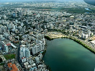
Santurce is a barrio of San Juan. Its population in 2020 was 69,469. It is also the biggest and most populated of all the barrios in the capital city with a bigger population than most municipalities of Puerto Rico and one of the most densely populated areas of the island .

Rail transport in Puerto Rico currently consists of a 10.7-mile (17.2 km) passenger metro system in the island's metropolitan area of San Juan. Its history can be traced back to the mid-19th century with the construction of a limited passenger line in Mayagüez. Between the late 19th and early 20th centuries, Puerto Rico's rail transport system expanded significantly, becoming one of the largest rail systems in the Caribbean at the time thanks to an economic boom in agriculture industries, especially the sugar cane industry. The rail system was expanded to include passenger travel with a direct line from the island's northern capital of San Juan to the western and southern cities and towns, greatly improving travel and communication within the island. However, the entire system was soon overshadowed by the arrival of the automobile, and by the 1950s was completely abandoned. Small remnants of this system still exist in some parts of Puerto Rico, some conserved for tourism purposes.
Barrio Playa, also known as Playa de Ponce, Ponce Playa, or La Playa, is one of the thirty-one barrios that comprise the municipality of Ponce, Puerto Rico. Along with Bucaná, Canas, Vayas, and Capitanejo, Playa is one of the municipality's five coastal barrios. Barrio Playa also incorporates several islands, the largest of which is Caja de Muertos. It was founded in 1831.

Canas is one of the 31 barrios in the municipality of Ponce, Puerto Rico. Along with Anón, Coto Laurel, Guaraguao, Quebrada Limón, Real, San Patricio, and Marueño, and the coastal barrio of Capitanejo, Canas is one of the municipality's nine bordering barrios. It borders the municipality of Peñuelas. Along with Playa, Bucana, Vayas and Capitanejo, Canas is also one of Ponce's five coastal barrios. It was founded in 1831.
Segundo is one of the 31 barrios of the municipality of Ponce, Puerto Rico. Along with Primero, Tercero, Cuarto, Quinto, and Sexto, Segundo is one of the municipality's six core urban barrios. It was organized in 1878. Barrio Segundo has 3 subbarrios: Baldority de Castro, Clausells, and Reparada.

Canas Urbano is one of the 31 barrio of the municipality of Ponce, Puerto Rico. Along with Machuelo Abajo, Magueyes Urbano, Portugués Urbano, and San Antón, Canas Urbano is one of the municipality's five originally rural barrios that are now also part of the urban zone of the city of Ponce. The name of this barrio is of native indigenous origin. It was created in 1953.
Timoteo Luberza de San Martín was a nineteenth-century Puerto Rican engineer from Ponce, Puerto Rico. He was responsible for the 1875 Ponce water supply system, including the dam in Rio Portugues, and the Calle del Agua masonry arch aqueduct in barrio Portugues Urbano in Ponce. In 1864, he served briefly as mayor of the nearby town of Yauco. He is best remembered for designing Plaza del Mercado de Ponce.
Pedro Adolfo de Castro (1895–1936) was a twentieth-century architect from San Juan, Puerto Rico.
The following is a timeline of the history of the city of Ponce, Puerto Rico.

San Juan Bay is the bay and main inlet adjacent to Old San Juan in northeastern Puerto Rico. It is about 3.5 miles (5.6 km) in length, the largest body of water in an estuary of about 97 square miles (250 km2) of channels, inlets and eight interconnected lagoons. The San Juan Bay is home to the island's busiest harbor and its history dates back to at least 1508.

Segundo Cardona Colom FAIA is a Puerto Rican architect and developer. His work has been recognized by the American Institute of Architects (AIA), by the Colegio de Arquitectos y Arquitectos Paisajistas de Puerto Rico as well as by the International Union of Architects. In 2006 Cardona was elected as Fellow of the American Institute of Architects. In 1992, he was awarded the Henry Klumb Award.

Bahía de Ponce is a bay in Barrio Playa, Ponce, Puerto Rico. The Bay is home to the most important commercial harbor on the Puerto Rico south coast and the second largest in Puerto Rico. The Cardona Island Light is located on the Bay to mark the way into the Bay from the nearby Caja de Muertos Light.
![]() Wikimedia Atlas of Puerto Rico
Wikimedia Atlas of Puerto Rico
| History |
| ||||||||
|---|---|---|---|---|---|---|---|---|---|
| Geography | |||||||||
| Ecology |
| ||||||||
| Politics | |||||||||
| Economy | |||||||||
| Society |
| ||||||||