
An ecoregion is an ecologically and geographically defined area that is smaller than a bioregion, which in turn is smaller than a biogeographic realm. Ecoregions cover relatively large areas of land or water, and contain characteristic, geographically distinct assemblages of natural communities and species. The biodiversity of flora, fauna and ecosystems that characterise an ecoregion tends to be distinct from that of other ecoregions. In theory, biodiversity or conservation ecoregions are relatively large areas of land or water where the probability of encountering different species and communities at any given point remains relatively constant, within an acceptable range of variation . Ecoregions are also known as "ecozones", although that term may also refer to biogeographic realms.

The Nearctic realm is one of the eight biogeographic realms constituting the Earth's land surface.
The Global 200 is the list of ecoregions identified by the World Wide Fund for Nature (WWF), the global conservation organization, as priorities for conservation. According to WWF, an ecoregion is defined as a "relatively large unit of land or water containing a characteristic set of natural communities that share a large majority of their species dynamics, and environmental conditions". For example, based on their levels of endemism, Madagascar gets multiple listings, ancient Lake Baikal gets one, and the North American Great Lakes get none.
Deserts and xeric shrublands are a biome defined by the World Wide Fund for Nature. Deserts and xeric shrublands form the largest terrestrial biome, covering 19% of Earth's land surface area. Ecoregions in this habitat type vary greatly in the amount of annual rainfall they receive, usually less than 250 millimetres (10 in) annually except in the margins. Generally evaporation exceeds rainfall in these ecoregions. Temperature variability is also diverse in these lands. Many deserts, such as the Sahara, are hot year-round, but others, such as East Asia's Gobi, become quite cold during the winter.

The ecology of California can be understood by dividing the state into a number of ecoregions, which contain distinct ecological communities of plants and animals in a contiguous region. The ecoregions of California can be grouped into four major groups: desert ecoregions, Mediterranean ecoregions, forested mountains, and coastal forests.

The Columbia Plateau is a geologic and geographic region that lies across parts of the U.S. states of Washington, Oregon, and Idaho. It is a wide flood basalt plateau between the Cascade Range and the Rocky Mountains, cut through by the Columbia River.
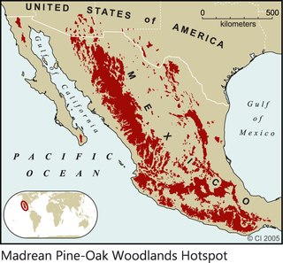
The Madrean pine–oak woodlands are subtropical woodlands found in the mountains of Mexico and the southwestern United States. They are a biogeographic region of the tropical and subtropical coniferous forests and temperate broadleaf and mixed forests biomes, located in North America.

Shrub-steppe is a type of low-rainfall natural grassland. While arid, shrub-steppes have sufficient moisture to support a cover of perennial grasses or shrubs, a feature which distinguishes them from deserts.
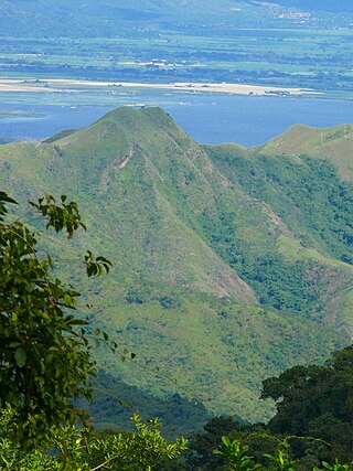
The Cordillera de la Costa montane forests is a montane ecoregion of the tropical and subtropical moist broadleaf forests biome, in the Venezuelan Coastal Range on the Caribbean Sea in northern Venezuela.

The Eastern Cascades Slopes and Foothills ecoregion is a Level III ecoregion designated by the United States Environmental Protection Agency (EPA) in the U.S. states of Oregon, Washington, and California. In the rain shadow of the Cascade Range, the eastern side of the mountains experiences greater temperature extremes and receives less precipitation than the west side. Open forests of ponderosa pine and some lodgepole pine distinguish this region from the Cascades ecoregion, where hemlock and fir forests are more common, and from the lower, drier ecoregions to the east, where shrubs and grasslands are predominant. The vegetation is adapted to the prevailing dry, continental climate and frequent wildfire. Volcanic cones and buttes are common in much of the region.

The Blue Mountains ecoregion is a Level III ecoregion designated by the United States Environmental Protection Agency (EPA) in the Pacific Northwest, mainly in the state of Oregon, with small areas over the state border in Idaho and southeastern Washington. It is also contiguous with the World Wildlife Fund's Blue Mountain forests ecoregion.

The Wyoming Basin shrub steppe ecoregion, within the deserts and xeric shrublands biome, is a shrub steppe in the northwestern United States.

The Great Basin montane forests is an ecoregion of the Temperate coniferous forests biome, as designated by the World Wildlife Fund (WWF).
Biogeographic classification of India is the division of India according to biogeographic characteristics. Biogeography is the study of the distribution of species (biology), organisms, and ecosystems in geographic space and through geological time. India has a rich heritage of natural diversity. India ranks fourth in Asia and tenth in the world amongst the top 17 mega-diverse countries in the world. India harbours nearly 11% of the world's floral diversity comprising over 17500 documented flowering plants, 6200 endemic species, 7500 medicinal plants and 246 globally threatened species in only 2.4% of world's land area. India is also home to four biodiversity hotspots—Andaman & Nicobar Islands, Eastern Himalaya, Indo-Burma region, and the Western Ghats. Hence the importance of biogeographical study of India's natural heritage.

The Idaho Batholith ecoregion is a Level III ecoregion designated by the United States Environmental Protection Agency (EPA) in the U.S. states of Idaho and Montana. It is contained within the following biomes designated by the World Wild Fund for Nature (WWF): temperate coniferous forests; temperate grasslands, savannas, and shrublands; and deserts and xeric shrublands.
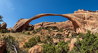
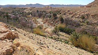
The Colorado Plateau shrublands is an ecoregion of deserts and xeric shrublands in the Western United States.

