The International Charter "Space and Major Disasters" is a non-binding charter which provides for the charitable and humanitarian acquisition and transmission of satellite data to relief organizations in the event of major disasters. Initiated by the European Space Agency and the French space agency CNES after the UNISPACE III conference held in Vienna, Austria, in July 1999, it officially came into operation on November 1, 2000, after the Canadian Space Agency signed onto the charter on October 20, 2000. Their space assets were then, respectively, ERS and ENVISAT, SPOT and Formosat, and RADARSAT.
The assorted satellite assets of various corporate, national, and international space agencies and entities provide for humanitarian coverage which is wide albeit contingent. First activated for a landslide in Slovenia in November 2000, [1] the Charter has since brought space assets into play for numerous floods, earthquakes, oil spills, forest fires, tsunamis, major snowfalls, volcanic eruptions, hurricanes and landslides, [2] [3] and furthermore (and unusually) for the search for Malaysia Airlines Flight 370 [4] and for the 2014 West Africa Ebola outbreak. [5] As of 2015, fifteen space agencies are signatories; dozens of satellites are available with image resolutions ranging from 8 kilometres (5 mi) per pixel to about 0.3 metres (1 ft) per pixel. [6] As of August 2018, it had had 579 activations, from 125 countries, and had 17 members, which contributed 34 satellites. [7] It won the prestigious William T. Pecora Award in 2017. [8]
As of 2012, [update] the live satellites and their instrumentalities were: The high resolution and very high resolution radar sensors of ENVISAT (decommissioned in April), RISAT-1, RADARSAT-1 & 2, TerraSAR-X and TanDEM-X; the high resolution and very high resolution optical sensors of SPOT satellites4 & 5, Pleiades, Landsat 5 & 7, PROBA1, UK-DMC 2, KOMPSAT-2, IRS-P5, Resourcesat-2, Oceansat-2, Cartosat-2, IMS-1, and RapidEye; the medium and low resolution optical sensors of POES, GOES, and SAC-C. Furthermore, specific agreements with other entities, including corporations, allow the Charter access to additional products of high and very high resolution from satellites such as the Formosat series, GeoEye, IKONOS, QuickBird, and WorldView. [10]
In 2014, the charter was activated 41 times for disasters in 30 countries. In that year the live satellites and their instrumentalities included: The high and very high resolution radar sensors of Risat-1, RADARSAT-2, TerraSAR-X, and TanDEM-X and Sentinel-1A; the optical high and very high resolution sensors of UK-DMC 2, Landsat 7 and 8, SPOT series 5, 6, and 7, Pléiades 1A and 1B, PROBA 1, SJ-9A, GF-1, KOMPSAT-2, IRS-P5 (Cartosat-1), Cartosat-2, Resourcesat-2, Oceansat-2, RapidEye, Kanopus-V, and Resurs-P, and the HDTV camera mounted the Kibo module of the International Space Station; and the medium and low optical sensors of POES, GOES, FY-3C, the Metop series, the first two Meteosat generations, and Meteor-M. Specific agreements with other entities allow for the usage of the Formosat, GeoEye, IKONOS, QuickBird, and WorldViews satellites, which have high and very high resolution. Archival data from defunct satellites such as ALOS, ENVISAT, ERS, CBERS, IRS-1C, Astra 1D, IRS P4, P6, IMS-1, RADARSAT-1, SAC-C, SPOT 1-3 & 4, UK-DMC, Landsat-5 and NigeriaSat are also available. [13]
This is very much a partial list; the 500th activation of the Charter was on 1 August 2016. [14]

An Earth observation satellite or Earth remote sensing satellite is a satellite used or designed for Earth observation (EO) from orbit, including spy satellites and similar ones intended for non-military uses such as environmental monitoring, meteorology, cartography and others. The most common type are Earth imaging satellites, that take satellite images, analogous to aerial photographs; some EO satellites may perform remote sensing without forming pictures, such as in GNSS radio occultation.

Envisat is a large Earth-observing satellite which has been inactive since 2012. It is still in orbit and considered space debris. Operated by the European Space Agency (ESA), it was the world's largest civilian Earth observation satellite.

RADARSAT-1 was Canada's first commercial Earth observation satellite. It utilized synthetic aperture radar (SAR) to obtain images of the Earth's surface to manage natural resources and monitor global climate change. As of March 2013, the satellite was declared non-operational and is no longer collecting data.

The Landsat program is the longest-running enterprise for acquisition of satellite imagery of Earth. It is a joint NASA / USGS program. On 23 July 1972, the Earth Resources Technology Satellite was launched. This was eventually renamed to Landsat 1 in 1975. The most recent, Landsat 9, was launched on 27 September 2021.
The British National Space Centre (BNSC) was an agency of the Government of the United Kingdom, organised in 1985, that coordinated civil space activities for the United Kingdom. It was replaced on 1 April 2010 by the UK Space Agency.

Satellite images are images of Earth collected by imaging satellites operated by governments and businesses around the world. Satellite imaging companies sell images by licensing them to governments and businesses such as Apple Maps and Google Maps.

Landsat 4 is the fourth satellite of the Landsat program. It was launched on July 16, 1982, with the primary goal of providing a global archive of satellite imagery. Although the Landsat Program is managed by NASA, data from Landsat 4 was collected and distributed by the U.S. Geological Survey. Landsat 4 science operations ended on December 14, 1993, when the satellite lost its ability to transmit science data, far beyond its designed life expectancy of five years. The satellite housekeeping telemetry and tracking continued to be maintained by NASA until it was decommissioned on June 15, 2001.

Cartosat-1 is a stereoscopic Earth observation satellite in a Sun-synchronous orbit, and the first one of the Cartosat series of satellites. The eleventh satellite of ISRO in Indian Remote Sensing Satellite (IRS) series. The satellite was launched by Indian Space Research Organisation and is operated by NTRO. Weighing around 1560 kg at launch, its applications will mainly be towards cartography in India.

RADARSAT is a Canadian remote sensing Earth observation satellite program overseen by the Canadian Space Agency (CSA). The program has consisted of:
Earth observation (EO) is the gathering of information about the physical, chemical, and biological systems of the planet Earth. It can be performed via remote-sensing technologies or through direct-contact sensors in ground-based or airborne platforms.
The Disaster Monitoring Constellation for International Imaging (DMCii) or just Disaster Monitoring Constellation (DMC) consists of a number of remote sensing satellites constructed by Surrey Satellite Technology Ltd (SSTL) and operated for the Algerian, Nigerian, Turkish, British and Chinese governments by DMC International Imaging. The DMC provides emergency Earth imaging for disaster relief under the International Charter for Space and Major Disasters, which the DMC formally joined in November 2005. Other DMC Earth imagery is used for a variety of civil applications by a variety of governments. Spare available imaging capacity is sold under contract.
The RADARSAT Constellation Mission (RCM) is a three-spacecraft fleet of Earth observation satellites operated by the Canadian Space Agency. The RCM's goal is to provide data for climate research and commercial applications including oil exploration, fishing, shipping, etc. With satellites smaller than RADARSAT-2, the RCM will provide new applications—made possible through the constellation approach—as well as continuing to provide C-band radar data to RADARSAT-2 users. One of its most significant improvements is in its operational use of synthetic-aperture radar (SAR) data. The primary goal of RCM is to provide continuous C-band SAR data to RADARSAT-2 users, as SAR imagery at a high temporal resolution is required by several users in the Canadian government. Other improvements include more frequent area coverage of Canada and reduced risk of a service interruption. The RCM will provide the world's most advanced, comprehensive method of maintaining Arctic sovereignty, conducting coastal surveillance, and ensuring maritime security.
Copernicus is the Earth observation component of the European Union Space Programme, managed by the European Commission and implemented in partnership with the EU member states, the European Space Agency (ESA), the European Organisation for the Exploitation of Meteorological Satellites (EUMETSAT), the European Centre for Medium-Range Weather Forecasts (ECMWF), the Joint Research Centre (JRC), the European Environment Agency (EEA), the European Maritime Safety Agency (EMSA), Frontex, SatCen and Mercator Océan.
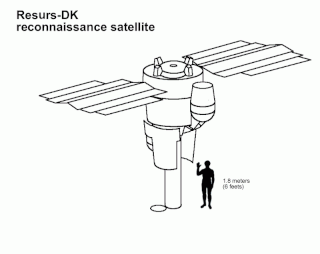
Resurs-DK No.1, also called Resurs-DK1, was a commercial Earth observation satellite capable of transmitting high-resolution imagery to the ground stations as it passed overhead. The spacecraft was operated by NTs OMZ, the Russian Research Center for Earth Operative Monitoring.
The Integrated Space Cell was the nodal agency within the Government of India with oversight of the security of its space based military and civilian hardware systems. It was to be jointly operated by all the three services of the Indian Armed Forces, the civilian Defence Research and Development Organisation and the Indian Space Research Organisation (ISRO). This agency was superseded by Defence Space Agency in 2019.

Svalbard Satellite Station or SvalSat is a satellite ground station located on Platåberget near Longyearbyen in Svalbard, Norway. Opened in 1997, it is operated by Kongsberg Satellite Services (KSAT), a joint venture between Kongsberg Defence & Aerospace and the Norwegian Space Centre (NSC). SvalSat and KSAT's Troll Satellite Station (TrollSat) in Antarctica are the only ground stations that can see a low altitude polar orbiting satellite on every revolution as the Earth rotates. As of 2021, the facility consists of 100 multi-mission and customer-dedicated antennas which operate in the C, L, S, X and K bands. The station provides ground services to more satellites than any other facility in the world.
BILSAT-1 was an Earth observation satellite designed and developed by TÜBİTAK Space Technologies Research Institute and produced in Turkey as part of the Disaster Monitoring Constellation (DMC) project in the context of a show-how program led by DMC International Imaging of Surrey Satellite Technology (SSTL).

Formosat-5 is the first Earth observation satellite manufactured and operated solely by the National Space Organization, the national civilian space agency of Taiwan. The satellite was launched from a Falcon 9 rocket on 24 August 2017, and placed into a Sun-synchronous orbit at an altitude of about 720 km. Formosat-5 can capture color and more detailed monochrome images, along with measuring the ionosphere plasma's properties.

The Defence Space Agency (DSA) is an integrated tri-services agency of the Indian Armed Forces headquartered in Bengaluru, Karnataka, India. The agency is tasked with operating the space-warfare and Satellite Intelligence assets of India. The DSA draws personnel from all three branches of the Armed Forces.
| Africa |
| ||||||||||||
|---|---|---|---|---|---|---|---|---|---|---|---|---|---|
| Americas |
| ||||||||||||
| Asia |
| ||||||||||||
| Europe |
| ||||||||||||
| Oceania | |||||||||||||
| World | |||||||||||||
| Former | |||||||||||||
| |||||||||||||