Related Research Articles

The Suffolk & Essex Coast & Heaths National Landscape is an Area of Outstanding Natural Beauty in Suffolk and Essex, England.
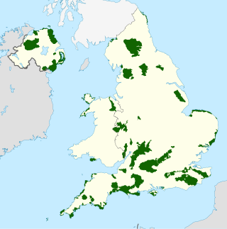
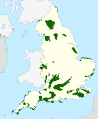
An Area of Outstanding Natural Beauty is one of 46 areas of countryside in England, Wales, or Northern Ireland that has been designated for conservation due to its significant landscape value. On 22 November 2023 the AONBs in England and Wales adopted a new name, National Landscapes, and are in the process of rebranding.
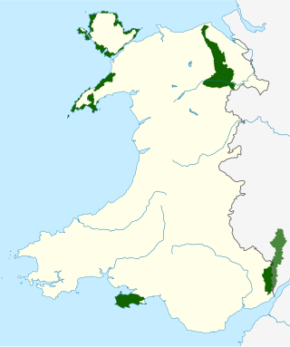
There are five Areas of Outstanding Natural Beauty (AONBs) in Wales, known from November 2023 as National Landscapes. AONBs are areas of countryside that have been designated for statutory protection, due to their significant landscape value, by initially the Government of the United Kingdom and later Welsh devolved bodies. Of the current five areas designated, four are wholly in Wales, with another spanning the Wales-England border, and in total AONBs account for 4% of Wales' land area.

The Isle of Purbeck is a peninsula in Dorset, England. It is bordered by water on three sides: the English Channel to the south and east, where steep cliffs fall to the sea; and by the marshy lands of the River Frome and Poole Harbour to the north. Its western boundary is less well defined, with some medieval sources placing it at Flower's Barrow above Worbarrow Bay. John Hutchins, author of The History and Antiquities of the County of Dorset, defined Purbeck's western boundary as the Luckford Lake steam, which runs south from the Frome. According to writer and broadcaster Ralph Wightman, Purbeck "is only an island if you accept the barren heaths between Arish Mell and Wareham as cutting off this corner of Dorset as effectively as the sea." The most southerly point is St Alban's Head.

The Kingsbridge Estuary in the South Hams area of Devon, England runs from Kingsbridge in the north to its mouth at the English Channel near Salcombe and lies between Bolt Head and Sharpitor to the west and Portlemouth Down to the east. The estuary is some 8.6 kilometres (5.3 mi) in length, with numerous side channels. Several of its creeks have independent names, including Blanksmill, Frogmore, Southpool, Batson and Bowcombe Creek.

The North Wessex Downs National Landscape is located in the English counties of Berkshire, Hampshire, Oxfordshire and Wiltshire. The name North Wessex Downs is not a traditional one, the area covered being better known by various overlapping local names, including the Berkshire Downs, the North Hampshire Downs, the White Horse Hills, the Lambourn Downs, the Marlborough Downs, the Vale of Pewsey and Savernake Forest.
The River Yar on the Isle of Wight, England, rises near the beach at Freshwater Bay, on the south coast, and flows only a few miles north to Yarmouth where it meets the Solent. Most of the river is a tidal estuary. Its headwaters have been truncated by erosion of the south coast.

Whitwell is a small village and former civil parish, now in the parish of Niton and Whitwell, on the south of the Isle of Wight, England, approximately 5 kilometres north-west of Ventnor, the village's nearest town. In addition to this, it is about five minutes away from its neighbouring small villages of Godshill and Niton. According to 2001 census data, the total population of the village was 578. There is a variety of stone and thatched housing, as well as some more modern housing, the most recent of which was completed in 2006.

The South Devon National Landscape covers 337 square kilometres, including much of the South Hams area of Devon and the rugged coastline from Jennycliff Bay to Elberry Cove near Brixham. The purpose of an Area of Outstanding Natural Beauty is to conserve and enhance the area's natural beauty. In South Devon this includes: undeveloped coastline, estuaries, geological and geomorphological features, expansive panoramic views, ancient agricultural field pattern, Devon banks, areas of high tranquility, dark night skies and natural nightscapes, historic features, green lanes, well known cultural associations, picturesque villages and hamlets. South Devon AONB was formally designated in August 1960 under the National Parks and Access to the Countryside Act 1949. The highest point in the AONB is Blackdown Camp at 199 metres above sea level.
The Council of the Isles of Scilly is a sui generis unitary local government authority covering the Isles of Scilly off the west coast of Cornwall. It is currently made up of 16 seats, with all councillors being independents. The council was created in 1890 as the Isles of Scilly Rural District Council and was renamed in 1974.

Newtown River is a large natural inland harbour located on the Isle of Wight's northwestern coast, named after the nearby village of Newtown. It is sometimes also referred to as Newtown Creek.

The Solway Coast is a designated Area of Outstanding Natural Beauty in northern Cumbria, England. It incorporates two areas of coastline along the Solway Firth, the first running from just north of the city of Carlisle, at the estuary of the rivers Esk and Eden, in a westerly direction as far as Silloth-on-Solway, including the villages of Bowness-on-Solway, Burgh-by-Sands, Port Carlisle, and Skinburness. The second area begins just north of the hamlet of Beckfoot, and runs south down the coast to the southern end of Allonby Bay near the village of Crosscanonby. Included in this area are the villages of Mawbray and Allonby, and the hamlets of Dubmill, Hailforth and Salta. The hamlet of Wolsty lies just outside the AONB. Beginning at Silloth, the B5300 coast road runs in a south-westerly direction, entering the AONB just north of Beckfoot, and exiting near Crosscanonby.
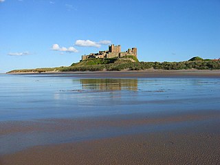
The Northumberland Coast National Landscape is a designated Area of Outstanding Natural Beauty (AONB) covering 40 miles (64 km) of coastline from Berwick-Upon-Tweed to the River Coquet estuary in the Northeast of England. Features include: Alnmouth, Bamburgh, Beadnell, Budle Bay, Cocklawburn Beach, Craster, Dunstanburgh Castle, the Farne Islands, Lindisfarne and Seahouses. It lies within the natural region of the North Northumberland Coastal Plain.

The South Hampshire Coast was an Area of Outstanding Natural Beauty (AONB) in Hampshire, England, UK that was subsumed into the New Forest National Park when it was established on 1 April 2005. It lies between the New Forest and the west shore of the Solent.
Tennyson Down is a hill at the west end of the Isle of Wight just south of Totland. Tennyson Down is a grassy, whale-backed ridge of chalk which rises to 482 ft/147m above sea level. Tennyson Down is named after the poet Lord Tennyson who lived at nearby Farringford House for nearly 40 years. The poet used to walk on the down almost every day, saying that the air was worth 'sixpence a pint'.

The Isle of Anglesey is a county off the north-west coast of Wales. It is named after the island of Anglesey, which makes up 94% of its area, but also includes Holy Island and some islets and skerries. The county borders Gwynedd across the Menai Strait to the southeast, and is otherwise surrounded by the Irish Sea. Holyhead is the largest town, and the administrative centre is Llangefni. The county is part of the preserved county of Gwynedd.

The Antrim Coast and Glens is an area of County Antrim in Northern Ireland, designated as an Area of Outstanding Natural Beauty in 1988.

Wales, a country that is part of the United Kingdom, contains protected areas under various designations. The largest designation by land area is Wales' three national parks, followed by the five Areas of Outstanding Natural Beauty.

Dorset is a county located in the middle of the south coast of England. It lies between the latitudes 50.512°N and 51.081°N and the longitudes 1.682°W and 2.958°W, and occupies an area of 2,653 km2. It spans 90 kilometres (56 mi) from east to west and 63 kilometres (39 mi) from north to south.

The Cornwall National Landscape covers 958 square kilometres (370 sq mi) in Cornwall, England, United Kingdom; that is, about 27% of the total area of the county. It comprises 12 separate areas, designated under the National Parks and Access to the Countryside Act 1949 for special landscape protection. Of the areas, eleven cover stretches of coastline; the twelfth is Bodmin Moor. The areas are together treated as a single Area of Outstanding Natural Beauty (AONB): all AONBs have been rebranded as National Landscapes since November 2023. Section 85 of the Countryside and Rights of Way Act 2000 places a duty on all relevant authorities when discharging any function affecting land within an AONB to have regard to the purpose of conserving and enhancing natural beauty. Section 89 places a statutory duty on Local Planning Authorities with an AONB within their administrative area to produce a 5-year management plan.
References
- ↑ "The Isle of Wight AONB". www.wightaonb.org.uk. Archived from the original on 10 October 2008. Retrieved 5 August 2009.