The Solway Firth is a firth that forms part of the border between England and Scotland, between Cumbria and Dumfries and Galloway. It stretches from St Bees Head, just south of Whitehaven in Cumbria, to the Mull of Galloway, on the western end of Dumfries and Galloway. The Isle of Man is also very near to the firth. The firth comprises part of the Irish Sea.

Allonby is a village on the coast of Cumberland in Cumbria, England. The village is on the B5300 road 5 miles (8.0 km) north of Maryport and 8 miles (13 km) south of Silloth. The village of Mawbray is 3 miles (4.8 km) to the north, and 3.5 miles (5.6 km) to the east is the village of Westnewton. The county town of Carlisle is located 26 miles (42 km) to the north east. Other nearby settlements include Crosscanonby, Edderside, Hayton, and Salta.

Beckfoot is a hamlet in the civil parish of Holme St Cuthbert in Cumbria, England. It is located on the B5300 coast road, three miles south of Silloth-on-Solway and two miles north of the village of Mawbray. The county town of Carlisle is twenty-five miles away to the east.

Crosscanonby is a village and civil parish in Cumbria, England, historically part of Cumberland, near the Lake District National Park in England. It is situated within the Solway Coast, designated an Area of Outstanding Natural Beauty.
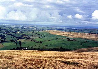
The Solway Plain or Solway Basin is a coastal plain located mostly in northwest Cumbria in England, extending just over the Scottish border to the low-lying area around Gretna and Annan. It lies generally north and west of Carlisle along the Solway Firth, and is drained by the rivers Esk and Lyne. It is associated with the westernmost part of Hadrian's Wall. In medieval times, clay houses known as dabbins were commonly built on the Solway Plain. The Solway coast has been designated an “Area of Outstanding Natural Beauty”.

Blitterlees is a small hamlet in the parish of Holme Low, one mile south of Silloth in Cumbria, United Kingdom. The hamlet of Wolsty is located approximately 1 mile (1.6 km) to the south as the crow flies, or 2.25 miles (3.62 km) by road, and Cumbria's county town, Carlisle, is located 23 miles (37 km) to the east. The B5300, known locally as the "coast road", runs through the village on its way to Beckfoot, Mawbray, Allonby, and ultimately Maryport.

Salta is a hamlet in the parish of Holme St Cuthbert in northwestern Cumbria, United Kingdom. It is 1.1 miles (1.8 km) southwest of the village of Mawbray, and 25.1 miles (40.4 km) southwest of the city of Carlisle. It has a population of about 35 people.
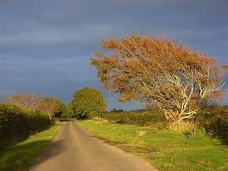
The B5300 is a B road which runs for approximately twelve miles between the towns of Silloth and Maryport in the Allerdale borough of Cumbria, United Kingdom. From north to south, it passes through the villages of Blitterlees, Beckfoot, Mawbray, Dubmill, and Allonby. It runs through the Solway Coast Area of Outstanding Natural Beauty, passes close to the Salta Moss Site of Special Scientific Interest, Milefortlet 21, a Roman archaeological site, the salt pans, a remnant of the Solway plain's medieval saltmaking industry, and the village of Crosscanonby. It is an important route for carrying goods to and from Silloth docks and Maryport harbour. It is also the major road connecting smaller coastal settlements with Maryport and Silloth, from where other roads lead to Workington, Whitehaven, Wigton, and Carlisle. A short section of the road between Dubmill and Mawbray was closed in February 2019 due to coastal erosion, and reopened in June 2019.

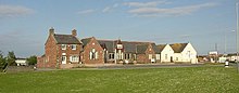
Holme St Cuthbert is a small village and civil parish in the county of Cumbria, United Kingdom. The village is located approximately 23 miles to the south-west of Carlisle, Cumbria's county town, and was historically in the county of Cumberland.

Edderside is a hamlet in the civil parish of Holme St. Cuthbert in Cumbria, United Kingdom. It is located approximately one mile as the crow files to the south-east of Mawbray, or two-and-a-half miles by road, and a similar distance east of Salta, and north-east of Allonby. The small hamlet of Jericho is located less than a mile to the north-east. Approximately 23 miles to the north-east is the city of Carlisle. Allonby Bay, an inlet of the Solway Firth, is one-and-a-half miles to the south-west, as is the B5300 coast road which runs between Silloth-on-Solway, six-and-a-half miles to the north, and Maryport, six miles to the south.

Newtown is a hamlet in the civil parish of Holme St Cuthbert in Cumbria, United Kingdom. It is located approximately two miles north-east of the village of Mawbray, a little over half-a-mile as the crow flies to the south-east of Beckfoot, and twenty-five miles west of the city of Carlisle. The B5300 coast road runs approximately three-quarters of a mile to the west of the hamlet, which goes to Maryport, nine-and-a-quarter miles to the south-west, and Silloth-on-Solway, approximately four miles to the north.
Holme Low is a civil parish in the Allerdale borough of Cumbria, United Kingdom. It borders the parishes of Holme St. Cuthbert and Holme Abbey to the south, the town of Silloth-on-Solway to the north-west, and has a short stretch of coastline on the Solway Firth to the west. To the north, it is bordered by lands common to Holme St. Cuthbert, Holme Low, and Holme Abbey, which is an unpopulated area. Holme Low had a population of 373 in 137 households at the 2001 census, reducing slightly in the 2011 Census to a population of 362 in 162 households.

Hailforth is a small hamlet in the civil parish of Holme St. Cuthbert, in Cumbria, United Kingdom. It is located approximately half a mile south-west of the village of Mawbray, and a similar distance north-east of Salta. Carlisle, Cumbria's county town, is situated twenty-five miles to the north-east. The hamlet consists of four houses, and is situated on the road which runs from Mawbray to the coast, where it joins the B5300 at Dubmill, three-quarters of a mile to the south-west.

Tarns is a small farming settlement in the civil parish of Holme St. Cuthbert in Cumbria, United Kingdom. It is located two miles north-east of the village of Mawbray, and twenty-three miles south-west of Carlisle, Cumbria's county town. The B5301 road runs through the settlement, and along that road the town of Silloth-on-Solway is located five-and-a-half miles to the north, and Aspatria four-and-a-half miles to the south-east. Other nearby settlements include Aikshaw, Goodyhills, Jericho, and New Cowper.

Allonby Bay is a crescent-shaped bay of the Solway Firth on the north-western shore of Cumbria, England. The bay is 5.5 miles (8.9 km) across. Its northern point is at Dubmill, between the village of Mawbray and the hamlet of Salta, and its southern end is just to the north of Maryport, near the village of Crosscanonby. The B5300 coast road follows the shoreline of Allonby Bay, running between Silloth in the north and Maryport in the south.

Wolsty is a small hamlet in the civil parish of Holme Low in Cumbria, England. It is located three-and-a-quarter miles south of Silloth-on-Solway, five miles west of Abbeytown, three-and-a-quarter miles north of the village of Mawbray, and twenty-three miles west of Cumbria's county town, Carlisle. The B5300 coast road, which heads north toward Silloth-on-Solway and south to Mawbray, Allonby, and Maryport, is three-quarters of a mile away by road, or less than a quarter of a mile by way of an unpaved farm track.

The B5302 is a B road which runs for approximately twelve-and-a-quarter miles between the towns of Silloth-on-Solway and Wigton in Cumbria, United Kingdom. From west to east, it passes through the villages of Causewayhead, Calvo, Abbeytown, Wheyrigg, and Waverbridge, and also passes near to Blackdyke and Blencogo. At its eastern end, it comes very close to the Solway Coast Area of Outstanding Natural Beauty, and passes by Silloth Airfield, left over from the Second World War. Several of the villages that the road passes through were formerly served by trains on the single-track Carlisle and Silloth Bay Railway, which closed with the Beeching axe in the 1960s. It is the main road connecting Silloth-on-Solway and surrounding settlements with the A596, and by extension, the city of Carlisle.
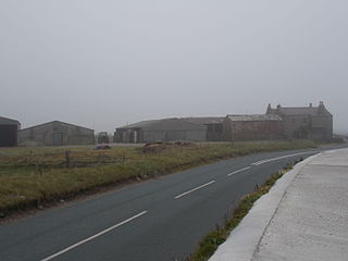
Dubmill is a settlement in the civil parish of Holme St. Cuthbert in Cumbria, United Kingdom. It is located approximately one mile south-west of the village of Mawbray, half-a-mile to the west of the hamlet of Salta, three-quarters of a mile south-west of the hamlet of Hailforth, and one-and-a-half miles north of the village of Allonby. Carlisle, Cumbria's county town, lies approximately twenty-eight miles to the north-east. The B5300, known locally as the coast road, runs through Dubmill.

Salta Moss is a raised blanket mire which is a Site of Special Scientific Interest ('SSSI') located in the hamlet of Salta, in Cumbria, United Kingdom. It was determined to be of biological interest under the Wildlife and Countryside Act 1981. The site, measuring 45.6 hectares, was officially designated in August 1982.