The Tamar is a river in south west England that forms most of the border between Devon and Cornwall. A part of the Tamar Valley is a World Heritage Site due to its historic mining activities.

Tavistock is an ancient stannary and market town within West Devon, England. It is situated on the River Tavy from which its name derives. At the 2011 census the three electoral wards had a population of 13,028. It traces its recorded history back to at least 961 when Tavistock Abbey, whose ruins lie in the centre of the town, was founded. Its most famous son is Sir Francis Drake.

The North Pennines is the northernmost section of the Pennine range of hills which runs north–south through northern England. It lies between Carlisle to the west and Darlington to the east. It is bounded to the north by the Tyne Valley and to the south by the Stainmore Gap.

Kit Hill, at 334 metres high, dominates the area between Callington and the River Tamar in southeast Cornwall, England, UK. The word 'Kit' comes from Old English for kite, a reference to birds of prey. Buzzards and sparrowhawks can still be seen on the hill. It is one of five Marilyn hills in Cornwall, the four others are Watch Croft, Brown Willy, Carnmenellis and Hensbarrow Beacon.

Trewellard is a small village on the north coast road between St Just and St Ives in Cornwall, England, United Kingdom. It lies along the B3306 road which connects St Ives to the A30 road. It is situated 7 miles from Land's End and 7 miles from Penzance. It is in the civil parish of St Just and the electoral division of St Just in Penwith.
Porthtowan is a small village in Cornwall, UK, which is a popular summer tourist destination. Porthtowan is on Cornwall's north Atlantic coast about 2 km (1.2 mi) west of St Agnes, 4 km (2.5 mi) north of Redruth, 10 km (6.2 mi) west of Truro and 15 km (9.3 mi) southwest of Newquay in the Cornwall and West Devon Mining Landscape, a World Heritage Site.

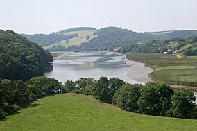
Calstock is a civil parish and a large village in south east Cornwall, England, United Kingdom, on the border with Devon. The village is situated on the River Tamar 6 miles (9.7 km) south west of Tavistock and 10 miles (16 km) north of Plymouth.

Perranuthnoe is a civil parish and a village in southwest Cornwall, England, United Kingdom. The parish population at the 2011 census was 2,184. The Parish includes the settlements of Goldsithney, Perran Downs,Perranuthnoe and part of Rosudgeon.The village of Perranuthnoe itself is situated on the east side of Mount's Bay approximately one mile (1.6 km) east of Marazion and four miles (6.5 km) east of Penzance.

Mining in Cornwall and Devon, in the southwest of Britain, is thought to have begun in the early-middle Bronze Age with the exploitation of cassiterite. Tin, and later copper, were the most commonly extracted metals. Some tin mining continued long after the mining of other metals had become unprofitable, but ended in the late 20th century. In 2021, it was announced that a new mine was extracting battery-grade lithium carbonate, more than 20 years after the closure of the last South Crofty tin mine in Cornwall in 1998.

Portreath is a civil parish, village and fishing port on the north coast of Cornwall, England, United Kingdom. The village is about three miles (5 km) west-north-west of Redruth. The village extends along both sides of a stream valley and is centred on the harbour and beach. West of the harbour entrance and breakwater are two sandy beaches that are popular with holidaymakers, surfers and naturists.

The Cornwall and West Devon Mining Landscape is a World Heritage Site which includes select mining landscapes in Cornwall and West Devon in the south west of England. The site was added to the World Heritage List during the 30th Session of the UNESCO World Heritage Committee in Vilnius, July 2006. Following plans in 2011 to restart mining at South Crofty, and to build a supermarket at Hayle Harbour, the World Heritage Committee drafted a decision in 2014 to put the site on the List of World Heritage in Danger, but this was rejected at the 38th Committee Session at Doha, Qatar, in favour of a follow-up Reactive Monitoring Mission.
Gunnislake is a large village in east Cornwall, England, United Kingdom. It is situated in the Tamar Valley approximately ten miles (16 km) north of Plymouth The first woman cabinet minister in the British Empire, Mary Ellen Smith, was born here in 1863.

The Culm Measures are a thick sequence of geological strata originating during the Carboniferous Period that occur in south-west England, principally in Devon and Cornwall, now known as the Culm Supergroup. Its estimated thickness varies between 3600 m and 4750 m though intense folding complicates it at outcrop. They are so called because of the occasional presence in the Barnstaple–Hartland area of a soft, often lenticular, sooty coal, which is known in Devon as culm. The word culm may be derived from the Old English word for coal col or from the Welsh word cwlwm meaning knot.

Morwellham Quay is an historic river port in Devon, England that developed to support the local mines. The port had its peak in the Victorian era and is now run as a tourist attraction and museum. It is the terminus of the Tavistock Canal, and has its own copper mine.

The Tavistock Canal is a canal in the county of Devon in England. It was constructed early in the 19th century to link the town of Tavistock to Morwellham Quay on the River Tamar, where cargo could be loaded into ships. The canal is still in use to supply water to a hydro-electric power plant at Morwellham Quay, and forms part of the Cornwall and West Devon Mining Landscape World Heritage Site. It is unusual for a canal, as it has a gentle slope over its length, resulting in a considerable flow of water.

New Quay is a small once industrial abandoned hamlet and intensive mining port on the steep, winding banks of the River Tamar in Devon. New Quay village is immediately east of and downstream of the similar port of Morwellham Quay. New Quay was an important copper, tin and later arsenic port serving the local mines including the George and Charlotte Mine, Bedford Consolidated Mine and Gawton Arsenic Mine. Since July 2006 New Quay is within the World Heritage Site that is the Cornwall and West Devon Mining Landscape.

Consolidated Mines, also known as Great Consolidated mine, but most commonly called Consols or Great Consols was a metalliferous mine about a mile ESE of the village of St Day, Cornwall, England. Mainly active during the first half of the 19th century, its mining sett was about 600 yards north–south; and 2,700 yards east–west, to the east of Carharrack. Although always much troubled by underground water, the mine was at times highly profitable, and it was the largest single producer of copper ore in Cornwall. Today the mine is part of the Cornwall and West Devon Mining Landscape World Heritage Site.
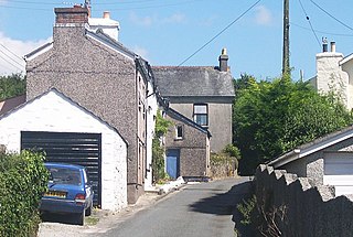
Norris Green is a village in Cornwall, England, UK. It was enlarged from a farming hamlet so that it now adjoins the neighbouring village of Higher Metherell. Both settlements are within the civil parish of Calstock which borders the River Tamar, the county boundary with Devon in south-east Cornwall.

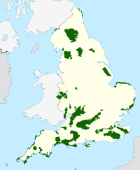
The Cornwall National Landscape covers 958 square kilometres (370 sq mi) in Cornwall, England, United Kingdom; that is, about 27% of the total area of the county. It comprises 12 separate areas, designated under the National Parks and Access to the Countryside Act 1949 for special landscape protection. Of the areas, eleven cover stretches of coastline; the twelfth is Bodmin Moor. The areas are together treated as a single Area of Outstanding Natural Beauty (AONB): all AONBs have been rebranded as National Landscapes since November 2023. Section 85 of the Countryside and Rights of Way Act 2000 places a duty on all relevant authorities when discharging any function affecting land within an AONB to have regard to the purpose of conserving and enhancing natural beauty. Section 89 places a statutory duty on Local Planning Authorities with an AONB within their administrative area to produce a 5-year management plan.

Devon Great Consols was a copper mine near Tavistock in Devon. The lease on the site was taken from the Duke of Bedford in 1844 by a group of investors. The 1,024 shares, sold at one pound each, were divided among the six men. Earlier attempts to mine this property had all ended in failure.