Nidderdale National Landscape

Last updated

Nidderdale National Landscape
Scar House Dam, Nidderdale - geograph.org.uk - 121004.jpg
Upper Nidderdale and Great Whernside
Nidderdale AONB locator map.svg
Location of the Nidderdale AONB in England
Location North Yorkshire, England
Nearest town Harrogate
Coordinates 54°05′12″N1°45′28″W / 54.086688°N 1.757728°W / 54.086688; -1.757728
Area233 sq mi (600 km2)
Established1994
Website http://www.nidderdaleaonb.org.uk

The Nidderdale National Landscape is an Area of Outstanding Natural Beauty in North Yorkshire, England, bordering the Yorkshire Dales National Park [1] to the east and south. It comprises most of Nidderdale itself, part of lower Wharfedale, the Washburn valley and part of lower Wensleydale, including Jervaulx Abbey and the side valleys west of the River Ure. It covers a total area of 233 square miles (600 km2). [2] The highest point in the Nidderdale AONB is Great Whernside, 704 metres (2,310 ft) above sea level, on the border with the Yorkshire Dales National Park.

Contents

The area is said to contain "remains from over 6,000 years of human activity"; there is evidence of "almost continuous settlement over this time with the exception of the Roman period for which evidence is scanty". [3]

According to the AONB, the area "is home to a diverse range of wildlife, important habitats and over 16,000 people". [4] The only town within the AONB is Pateley Bridge in Nidderdale, one of the Yorkshire Dales. Otley and Ilkley lie just to the south of the AONB, and Masham and Ripon are just to the east.

History

In 1947, when the Hobhouse Report recommended the creation of the Yorkshire Dales National Park, it proposed that Nidderdale should be excluded and given a different conservation status. Accordingly, Nidderdale was not included in the National Park when it was designated in 1954. In 1963 the then West Riding County Council proposed that Nidderdale should be added to the National Park, but the proposal met with opposition from the district councils which would have lost some of their powers to the county council. The West Riding National Park Committee, and its successor the Yorkshire Dales National Park Committee, did not entirely abandon the idea until 1988, when the alternative AONB designation was proposed. [5]

The eastern boundary of the National Park had been set at East Witton, as recommended by the Hobhouse Report. The section of Wensleydale below East Witton had not been considered for national park status, but was added to the new AONB. Similarly, the new AONB also included the Washburn Valley and the area of lower Wharfedale between the Washburn Valley and the National Park, which had not been considered for national park status. The AONB was designated in 1994 with its current boundaries. [6]

Geography

Nidderdale

Countryside near Pateley Bridge Near-Pateley-Bridge-04.JPG
Countryside near Pateley Bridge

The AONB includes all of Nidderdale except a small area in the lower dale around Hampsthwaite. In the lower dale, below Pateley Bridge, attractions include Brimham Rocks and the Coldstones Cut. In the less populated upper dale there are a series of reservoirs, Gouthwaite Reservoir (a nature reserve), Scar House Reservoir and at the very top of the dale Angram Reservoir, dominated by Great Whernside and Little Whernside.

Lower Wharfedale and the Washburn Valley

Washburn Valley in winter Washburn Valley - geograph.org.uk - 1721355.jpg
Washburn Valley in winter

The southern part of the AONB includes the reservoirs of the Washburn Valley, Lindley Wood, Swinsty, Fewston and Thruscross.

Lower Wensleydale and side valleys

The eastern part of the AONB includes the valleys of the River Burn (including Colsterdale), River Laver and River Skell. Fountains Abbey and Jervaulx Abbey both lie within the AONB, and Hackfall Wood is on the south bank of the River Ure.

Lower Wharfedale Panorama.jpg
Overlooking Lower Wharfedale just North of Otley (which is to the left). Ilkley Moor is in the background

Tourism

The AONB can be reached by bus from Harrogate to Pateley Bridge, by train to Harrogate, and by highway: "A1(M) and the A61 to the east, and the A65, A59, M65 and M62 to the south". [7]

The AONB supports the tourism sector in line with the Dales Tourism Strategy & Action Plan for sustainable tourism. [8] In 2013, revenue from tourism within the area was just under £35 million plus "indirect expenditure" by visitors of about £20 million. [9]

Walking is a popular activity. The AONB Web site provides directions for popular walks, but also offers information on canoeing and kayaking, caving, climbing, cycling, fishing and horse riding. [10] Three long-distance trails traverse the AONB, the Nidderdale Way up and down Nidderdale from south east to north west, the Six Dales Trail from Otley in the south to Wensleydale in the north, and the Yorkshire Heritage Way from Wharfedale in the south to Ripon in the north. Upper Nidderdale is a popular area for mountain biking, [11] and caving takes place in the Upper Nidderdale caves.

The grouse moors on the higher land offer some of the best shooting in the United Kingdom. [12] One source states that grouse shooting is primarily an activity for the wealthy; in 2008, the activity contributed "more than £600,000 in wages for people such as gamekeepers and beaters, £250,000 to local businesses such as pubs and guest houses, and around £1.75million for land management". [13] The season in 2020 ran from 12 August to 10 December. [14]

Governance

Like most AONBs, and unlike national parks, the Nidderdale AONB is managed by local authorities through the Joint Advisory Committee, "a partnership organisation made up of elected representatives from the local authority and parish councils, and representatives from landowning and community interest groups". [15] A small team based at Pateley Bridge reports to the JAC. [16]

The entire AONB is within North Yorkshire, and since 1 April 2023 North Yorkshire Council has been lead authority for the AONB. Almost all of Nidderdale AONB is within the area of the former Borough of Harrogate. Small areas of land to the north are within the former Richmondshire and Hambleton districts. [17]

Related Research Articles

<span class="mw-page-title-main">Wharfedale</span> Valley in Yorkshire, England

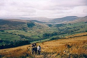
Wharfedale is the valley of the upper parts of the River Wharfe and one of the Yorkshire Dales. It is situated in North Yorkshire, and the cities of Leeds and Bradford in West Yorkshire. It is the upper valley of the River Wharfe. Towns and villages in Wharfedale include Buckden, Kettlewell, Conistone, Grassington, Hebden, Bolton Abbey, Addingham, Ilkley, Burley-in-Wharfedale, Otley, Pool-in-Wharfedale, Arthington, Collingham and Wetherby. Beyond Wetherby, the valley opens out and becomes part of the Vale of York.

<span class="mw-page-title-main">Yorkshire Dales</span> Upland area of the Pennines in Northern England

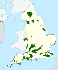
The Yorkshire Dales are a series of valleys, or dales, in the Pennines, a range of hills in England. They are mostly located in the ceremonial county of North Yorkshire, but extend into Cumbria and Lancashire; they were historically entirely within Yorkshire. The majority of the dales are within the Yorkshire Dales National Park, created in 1954. The exception is the area around Nidderdale, which forms the separate Nidderdale Area of Outstanding Natural Beauty.

<span class="mw-page-title-main">Wensleydale</span> Upper valley of the River Ure in North Yorkshire, England

Wensleydale is a valley in North Yorkshire, England. It is one of the Yorkshire Dales, which are part of the Pennines. The dale is named after the village of Wensley, formerly the valley's market town. The principal river of the valley is the Ure, which is the source of the alternative name Yoredale. The majority of the dale is within the Yorkshire Dales National Park; the part below East Witton is within the national landscape of Nidderdale.

<span class="mw-page-title-main">Yorkshire Dales National Park</span> National park in England

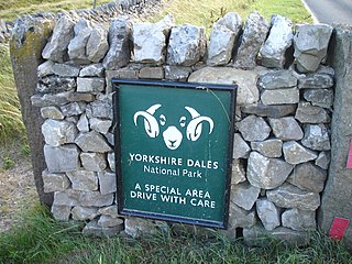
The Yorkshire Dales National Park is a 2,178 km2 (841 sq mi) national park in England covering most of the Yorkshire Dales, with the notable exception of Nidderdale. Most of the park is in North Yorkshire, with a sizeable area in Cumbria and a small part in Lancashire. The park was designated in 1954, and extended in 2016. Over 95% of the land in the Park is under private ownership; there are over 1,000 farms in this area.

<span class="mw-page-title-main">Skipton and Ripon (UK Parliament constituency)</span> Parliamentary constituency in the United Kingdom, 1983 onwards

Skipton and Ripon is a constituency in North Yorkshire represented in the House of Commons of the UK Parliament since 2010 by Julian Smith, a Conservative.

<span class="mw-page-title-main">Pateley Bridge</span> Market town in North Yorkshire, England

Pateley Bridge is a market town in Nidderdale in the county and district of North Yorkshire, England. Historically part of the West Riding of Yorkshire, it lies on the River Nidd. It is in the Yorkshire Dales and just outside the Yorkshire Dales National Park.

<span class="mw-page-title-main">Great Whernside</span> Mountain in the Yorkshire Dales, England

Great Whernside is a fell in the Yorkshire Dales, England, not to be confused with Whernside, some 17 miles (27 km) to the west. Its summit is the highest point of the eastern flank of Wharfedale above Kettlewell. Great Whernside forms the watershed between Wharfedale and Nidderdale, and is on the boundary between the Yorkshire Dales National Park and Nidderdale Area of Outstanding Natural Beauty. The River Nidd rises on the eastern slopes of Great Whernside, above Angram Reservoir.

<span class="mw-page-title-main">Nidderdale</span> Valley in Yorkshire, England

Nidderdale, historically also known as Netherdale, is one of the Yorkshire Dales in North Yorkshire, England. It is the upper valley of the River Nidd, which flows south underground and then along the dale, forming several reservoirs including the Gouthwaite Reservoir, before turning east and eventually joining the River Ouse.

<span class="mw-page-title-main">East Witton</span> Village and civil parish in North Yorkshire, England

East Witton is a village and civil parish in Wensleydale in North Yorkshire, England. It lies south of Leyburn, in the Richmondshire district. Richard Whiteley is buried there; he and his partner, Kathryn Apanowicz, lived in the village.

<span class="mw-page-title-main">River Nidd</span> River in North Yorkshire, England

The River Nidd is a tributary of the River Ouse in the English county of North Yorkshire. In its first few miles it is dammed three times to create Angram Reservoir, Scar House Reservoir and Gouthwaite Reservoir, which attract a total of around 150,000 visitors a year. The Nidd can overflow the reservoirs, flooding the caves in the valley. In such cases the river overflows into the normally dry river bed past Lofthouse through to Gouthwaite Reservoir. The Yorkshire Dales Rivers Trust YDRT has a remit to conserve the ecological condition of the River Nidd from its headwaters to the Humber estuary.

<span class="mw-page-title-main">River Washburn</span> River in North Yorkshire, England

The River Washburn is a river in Yorkshire, England. It originates high in the Yorkshire Dales and ends where it meets the River Wharfe. It lies within the Nidderdale Area of Outstanding Natural Beauty.

<span class="mw-page-title-main">Thruscross Reservoir</span> Reservoir in North Yorkshire, England

Thruscross Reservoir is the northernmost of four reservoirs in the Washburn valley, lying north of Otley and west of Harrogate in North Yorkshire, England, near the hamlet of Thruscross. It can be found on an unclassified road from the A59 road. Permission to construct the reservoir was granted via a water order in 1960 and Thruscross was completed in 1966, much later than the other three reservoirs which date back to the nineteenth century.

<span class="mw-page-title-main">Coverdale, North Yorkshire</span> Valley of the Yorkshire Dales, England

Coverdale is a dale in the far east of the Yorkshire Dales, North Yorkshire, England. It takes its name from the River Cover, a tributary of the River Ure. The dale runs south-west from the eastern end of Wensleydale to the dale head at a pass, known as Park Rash Pass, between Great Whernside to the south and Buckden Pike to the north. It is accessible by a single track road, which runs the length of the dale and over the pass to Kettlewell in Wharfedale. The name is taken from that of the River Cover, which is of Brittonic origin. Ekwall suggested that it might mean "hollow stream", but more recently Andrew Breeze has argued that it is cognate with Welsh gofer "streamlet".

The Six Dales Trail is a long distance footpath in North Yorkshire, England, with a short section in West Yorkshire. It is 38 miles (61 km) long and connects Otley and Middleham.

<span class="mw-page-title-main">Little Whernside</span>

Little Whernside is a hill in the Yorkshire Dales, North Yorkshire, England, 2.82 miles (4.54 km) north east of Great Whernside. It is on the boundary between the Yorkshire Dales National Park and Nidderdale Area of Outstanding Natural Beauty, and forms part of the watershed between Coverdale and Nidderdale. The highest point is marked by a cairn, a few metres inside the National Park.

<span class="mw-page-title-main">Scotgate Ash Quarry</span> Disused quarry in North Yorkshire, England

Scotgate Ash Quarry or Scot Gate Ash Quarry, was the collective name for extensive quarry workings that were on the northern edge of Pateley Bridge, North Yorkshire, England. When the quarry was last in use, the area was in the West Riding of Yorkshire, and was described as being the largest quarry in West Yorkshire.

<span class="mw-page-title-main">Yorkshire Water Way</span>

The Yorkshire Water Way is a 104-mile (167 km) path that runs from Kettlewell in North Yorkshire to Langsett in South Yorkshire. It was devised by Mark Reid in conjunction with Yorkshire Water (YW) and it passes by over more than 20 reservoirs which are operated by Yorkshire Water.

The Yorkshire Heritage Way is a 42-mile (68 km) footpath in northern England. It links the contrasting cities of Bradford in West Yorkshire and Ripon in North Yorkshire, and passes through two UNESCO World Heritage Sites: Saltaire, and Fountains Abbey and Studley Royal Park.

References

  1. Nidderdale
  2. Nidderdale AONB website
  3. NIDDERDALE AONB
  4. Nidderdale AONB State of Nature report
  5. Ray Woolmore (May 2002). "Yorkshire Dales National Park" (PDF). Designation History Series. Natural England. Archived from the original (PDF) on 5 June 2014. Retrieved 11 May 2015.
  6. "Nidderdale Area of Outstanding Natural Beauty". Visit Harrogate. Retrieved 15 May 2015.
  7. Planning your visit
  8. Tourism businesses
  9. Facts and Figures
  10. Planning Your Trip
  11. Nidderdale AONB: Mountain Biking
  12. Olivia Edward (2009). "Nidderdale". Geographer magazine.
  13. Nidderdale
  14. Open access
  15. Joint Advisory Committee
  16. Our team
  17. "Nidderdale AONB Management Plan 2014-2019" (PDF). p. 5. Archived from the original (PDF) on 22 December 2016. Retrieved 27 August 2017.