
McKinley County is a county in the northwestern section of the U.S. state of New Mexico. As of the 2020 United States Census, its population was 72,902. Its county seat is Gallup. The county was created in 1901 and named for President William McKinley.

Nakaibito is a census-designated place (CDP) in McKinley County, New Mexico, United States. The population was 455 at the 2000 census.

Yah-ta-hey is a census-designated place (CDP) in McKinley County, New Mexico, United States. As of the 2000 census, the CDP population was 580. The English name for this place is an approximation of a Navajo greeting, though the actual Navajo name means "like a devil", in reference to J.B. Tanner, who operated the trading post located here; the same name is used for Aneth, Utah, where Tanner also worked.
Gallup-McKinley County Schools (GMCS) is a school district based in Gallup, New Mexico which serves students from Gallup and surrounding areas of McKinley County.
Hiroshi Miyamura High School is a high school in Gallup, New Mexico, United States. Formerly known as Gallup Junior High School, it was renamed Miyamura High School in 2007 as part of the Gallup-McKinley County Schools’ plan to create a second high school to serve Gallup, and was renovated from 2008 to 2010. The school's location was the site of the old Gallup High School campus from 1962 to 1998, before the latter moved to Gallup's west side. Miyamura High School is named after Korean War hero and Medal of Honor recipient, Hiroshi Miyamura.
Continental Divide is an unincorporated community in McKinley County, New Mexico, United States.
Prewitt is an unincorporated community and census-designated place in McKinley County, New Mexico, United States. Prewitt is located along Interstate 40, 18 miles (29 km) northwest of Grants. Prewitt has a post office with ZIP code 87045.
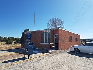
Rehoboth is an unincorporated community in McKinley County, New Mexico, United States. Rehoboth is located along Interstate 40, 5 miles (8.0 km) east of downtown Gallup. Rehoboth has a post office with ZIP code 87322. It has a population of 56 permanent residents.
Vanderwagen is an unincorporated community in McKinley County, New Mexico, United States. Vanderwagen is located along New Mexico State Road 602, 17.5 miles (28.2 km) south of Gallup.
The Gallup Refinery, also known as the Ciniza Refinery, was an American oil refinery. The facility is located in northwestern New Mexico along Interstate 40, approximately 20 miles east of the city center of Gallup and near the town of Jamestown, New Mexico. The facility occupies 880 acres in McKinley County and employed approximately 220 employees as of March 2019. The facility processed approximately 26,000 barrels of crude oil per day and produced gasoline, diesel, heavy fuel oil, and propane.
Timberlake is a census-designated place (CDP) in McKinley and Cibola counties, New Mexico, United States. It was first listed as a CDP prior to the 2020 census.
Bluewater is a census-designated place (CDP) in McKinley County, New Mexico, United States. It was first listed as a CDP prior to the 2020 census.
Catalpa Canyon is a census-designated place (CDP) in McKinley County, New Mexico, United States. It was first listed as a CDP prior to the 2020 census.
Crestview is a census-designated place (CDP) in McKinley County, New Mexico, United States. It was first listed as a CDP prior to the 2020 census.
Iyanbito is an unincorporated community and census-designated place (CDP) in McKinley County, New Mexico, United States, on the Navajo Nation. It was first listed as a CDP prior to the 2020 census.
Manuelito is a census-designated place (CDP) on the Navajo Nation in McKinley County, New Mexico, United States. It was first listed as a CDP prior to the 2020 census.
Ojo Encino is an unincorporated community and census-designated place (CDP) in McKinley County, New Mexico, United States, on the Navajo Nation. It was first listed as a CDP prior to the 2020 census.
Purty Rock is a census-designated place (CDP) in McKinley County, New Mexico, United States. It was first listed as a CDP prior to the 2020 census.
Sagar is a census-designated place (CDP) in McKinley County, New Mexico, United States. It was first listed as a CDP prior to the 2020 census.
Williams Acres is an unincorporated community and census-designated place (CDP) in McKinley County, New Mexico, United States. It was first listed as a CDP prior to the 2020 census.


