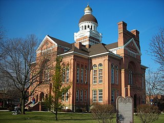
Paulding County is a county located in the U.S. state of Ohio. As of the 2020 census, the population was about 18,806. Its county seat is Paulding. The county was created in 1820 and later organized in 1839. It is named for John Paulding, one of the captors of Major John André in the American Revolutionary War.
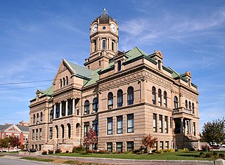
Auglaize County is a county in Northwestern Ohio, United States. As of the 2020 census, the population was 46,442. Its county seat and largest city is Wapakoneta.

St. Marys is a city in Auglaize County, Ohio, United States. Located in western Ohio, it is 11 miles (18 km) west of Wapakoneta and 20 miles (32 km) east of the Ohio/Indiana border. The city is located on a portage between the St. Marys and Auglaize river systems, which was a significant factor in its development before the era of canals. The population was 8,397 at the 2020 census. It is included in the Wapakoneta, Ohio, Micropolitan Statistical Area. It was founded in 1823 and takes its name from the nearby St. Marys River.

The Wabash and Erie Canal was a shipping canal that linked the Great Lakes to the Ohio River via an artificial waterway. The canal provided traders with access from the Great Lakes all the way to the Gulf of Mexico. Over 460 miles long, it was the longest canal ever built in North America.

The Auglaize River is a 113-mile-long (182 km) tributary of the Maumee River in northwestern Ohio in the United States. It drains a primarily rural farming area in the watershed of Lake Erie. The name of the river was derived from the French term for it. The French called it "rivière à la Grande Glaize", referring to the soil in the area.

Flatrock Creek is a 57.2-mile-long (92.1 km) tributary of the Auglaize River in northeastern Indiana and northwestern Ohio in the United States. It drains a primarily rural farming area in the watershed of Lake Erie.

State Route 66 is a north–south state highway in the northwestern portion of the U.S. state of Ohio. Its southern terminus is at U.S. Route 36 (US 36) in Piqua, and its northern terminus is at US 20 in Fayette. South of Defiance it generally follows the route of the former Miami and Erie Canal.

Defiance Township is one of the twelve townships of Defiance County, Ohio, United States. The 2020 census found 13,216 people in the township.

Hicksville Township is one of the twelve townships of Defiance County, Ohio, United States. The 2020 census found 4,872 people in the township.

Highland Township is one of the twelve townships of Defiance County, Ohio, United States. The population at the 2020 census was 2,284.

Mark Township is one of the twelve townships of Defiance County, Ohio, United States. The 2020 census found 902 people in the township.

Noble Township is one of the twelve townships of Defiance County, Ohio, United States. The 2020 census found 5,909 people in the township.

Auglaize Township is one of the twelve townships of Paulding County, Ohio, United States. The 2000 census found 1,535 people in the township.
Kossuth is an unincorporated community located in eastern Salem Township, Auglaize County, Ohio, United States.

Westminster is an unincorporated community in western Auglaize Township, Allen County, Ohio, United States. It lies along State Route 117 just north of its intersection with State Route 196, 6½ miles north of Waynesfield and 7+1⁄2 miles (12.1 km) southeast of the downtown part of the city of Lima, the county seat of Allen County. The upper reaches of the Auglaize River flow past the community.

State Route 111 (SR 111) is a 31.49-mile (50.68 km) state route that runs between the Indiana state line and Defiance in the US state of Ohio. Most of the route is a rural two-lane highway and passes through both farmland and residential properties. For some of its path, SR 111 runs generally parallel to the north of the Auglaize River.

The Miami and Erie Canal Deep Cut is a well-preserved long section of the Miami and Erie Canal near Spencerville in western Ohio. The 6,600-foot (2,000 m) segment represents one of the major construction efforts of the canal; in order to avoid using locks to go over a ridge, the canal was dug deeply into it, far more than the 5-foot (1.5 m) depth of the canal itself. Workers dug the canal bed up to 52 feet (16 m) into the blue clay ridge that separated the St. Marys and Auglaize River watersheds. It is a United States National Historic Landmark. The cut is owned by the state and managed jointly by Johnny Appleseed MetroParks and the Heritage Trails Park District as Deep Cut Historical Park, with multi-use trails and a picnic area.
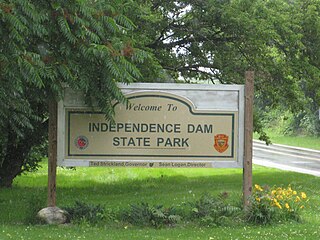
Independence Dam State Park is a 591-acre (239 ha) public recreation area located on the banks of the Maumee River three miles east of Defiance in Defiance County, Ohio, United States. The state park features ruins of the Miami and Erie Canal. Recreational features include boating, fishing, hiking, picnicking, and primitive camping.

Holy Rosary Catholic Church is a Roman Catholic parish on the east side of St. Marys, Ohio, United States. Established in 1852, the church has been recognized for its historic 1860s church building, which was demolished amid a period of growth in the 1970s and replaced with a modernist structure.
Craig Riedel is an American politician who served as the state representative for the 82nd District of the Ohio House of Representatives from 2017 to 2022. He is a Republican. The 82nd district consists of Defiance, Paulding and Van Wert counties as well as a portion of Auglaize County. Riedel is a candidate in the 2024 election for Ohio's 9th congressional district.


