
Germantown is an unincorporated community in northern Liberty Township, Washington County, Ohio, United States. It lies along the Paw Paw Creek near the boundary with Noble County.
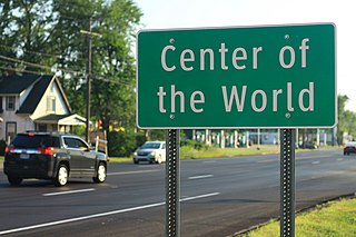
Center of the World is an unincorporated community in far eastern Braceville Township, Trumbull County, Ohio, United States. It consists of several houses and a few retail establishments centered at the crossroads where State Routes 82 and 5 diverge.

Conneaut Creek is a 43.5-mile (70.0 km) tributary of Lake Erie in northwestern Pennsylvania and northeastern Ohio in the United States. Via Lake Erie, the Niagara River and Lake Ontario, it is part of the watershed of the St. Lawrence River, which flows to the Atlantic Ocean.

Lees Creek, also known as Centerville, is an unincorporated community in central Wayne Township, Clinton County, Ohio, United States. It lies at the intersection of State Route 729 with Cox Road, 6 miles south of Sabina and 12 miles (19 km) southeast of Wilmington, the county seat of Clinton County. It lies between the headwaters of the Middle Fork of Lees Creek, to the southeast, and the Anderson Fork of Caesar Creek. it had a post office, with the ZIP code 45138. The Post Office closed in 2012 and the town, including East Clinton High School, now carries a Sabina mailing address.

The Mohican River is a principal tributary of the Walhonding River, about 40 miles (64 km) long, in north-central Ohio in the United States. Via the Walhonding, Muskingum and Ohio Rivers, it is part of the watershed of the Mississippi River, draining an area of 999 square miles (2,590 km2).

Roundhead is an unincorporated community in southeastern Roundhead Township, Hardin County, Ohio, United States. It has a post office with the ZIP code 43346.

Damascus is an unincorporated community and census-designated place in southern Mahoning and northern Columbiana counties in the U.S. state of Ohio. As of the 2020 census, it had a population of 418. The community lies at the intersection of U.S. Route 62 and State Routes 173 and 534.

Wolf Run is an unincorporated community in eastern Springfield Township, Jefferson County, Ohio, United States. It has a post office with the ZIP code 43970. The stream of Wolf Run, which flows northward past the community, is a tributary of Goose Creek, which in turn flows southward to meet Cross Creek in Harrison County's German Township, which in turn flows eastward to meet the Ohio River at Mingo Junction.
Vincent is a census-designated place in southern Barlow Township, Washington County, Ohio, United States. It has a post office with the ZIP code 45784. It lies along State Route 339 near Tupper Creek, a subsidiary of the Little Hocking River, which in turn meets the Ohio River at Little Hocking to the south.

Reno is a census-designated place in southern Marietta Township, Washington County, Ohio, United States. It has a post office with the ZIP code 45773. It is located on the Ohio River a short distance below the county seat of Marietta. State Route 7 forms its main street.

Little Hocking is a census-designated place in southern Belpre Township, Washington County, Ohio, United States. It has a post office with the ZIP code 45742.

Barlow is an unincorporated community in western Barlow Township, Washington County, Ohio, United States. Although it is unincorporated, it has a ZIP code 45712. It lies at the intersection of State Routes 339 and 550 near the South Fork of Wolf Creek, which meets the Muskingum River at Waterford to the north.

Roselms is an unincorporated community in southwestern Washington Township, Paulding County, Ohio, United States, in the northwestern part of the state. It lies along State Route 114 midway between Grover Hill and Mandale, about 3 miles (5 km) from each. Its elevation is 718 feet (219 m).

Salt Fork State Park is a public recreation area located six miles (9.7 km) north of Lore City in Guernsey County, Ohio. It is the largest state park in Ohio, encompassing 17,229 acres (6,972 ha) of land and 2,952 acres (1,195 ha) of water. The grounds include the Kennedy Stone House, which is listed on the National Register of Historic Places. The park is managed by the Ohio Department of Natural Resources Division of Parks and Watercraft.
Murraysville is an unincorporated community in northern Jackson County, West Virginia, United States, along the Ohio River across from Long Bottom, Ohio. It lies along Murraysville Road, north of the city of Ripley, the county seat of Jackson County. Its elevation is 591 feet (180 m).
This is a list of the National Register of Historic Places listings in Adams County, Ohio.

This is a list of the National Register of Historic Places listings in Preble County, Ohio.

U.S. Route 421 (US 421) in the U.S. state of Kentucky is a 250.536-mile-long (403.199 km) north–south United States highway that traverses twelve counties in the central and eastern parts of the state. It travels in a southeast-to-northwest path from the Virginia state line near Pennington Gap to the Indiana state line, on the Ohio River at Milton, Kentucky and Madison, Indiana.
Columbia Center is a historic neighborhood of the city of Pataskala in Licking County, Ohio, United States. It lies slightly more than 1 mile (1.6 km) west of Pataskala's downtown.

