Oakwood, Paulding County, Ohio

Last updated

Oakwood, Ohio
Oakwoodohio.JPG
Downtown Oakwood
OHMap-doton-Oakwood Paulding County.png
Location of Oakwood, Paulding County, Ohio
Map of Paulding County Ohio Highlighting Oakwood Village.png
Location of Oakwood in Paulding County
Coordinates: 41°05′35″N84°22′37″W / 41.09306°N 84.37694°W / 41.09306; -84.37694
Country United States
State Ohio
County Paulding
Township Brown
Area
[1]
  Total0.70 sq mi (1.82 km2)
  Land0.70 sq mi (1.82 km2)
  Water0.00 sq mi (0.00 km2)
Elevation
[2]
715 ft (218 m)
Population
 (2020)
  Total546
  Density777.78/sq mi (300.17/km2)
Time zone UTC-5 (Eastern (EST))
  Summer (DST) UTC-4 (EDT)
ZIP code
45873
Area code 419
FIPS code 39-57792 [3]
GNIS feature ID2399546 [2]

Oakwood is a village in Paulding County, Ohio, United States. The population was 546 at the 2020 census.

Contents

Geography

According to the United States Census Bureau, the village has a total area of 0.59 square miles (1.53 km2), all land. [4]

Demographics

Historical population
CensusPop.Note
1880 23
1890 3781,543.5%
1900 342−9.5%
1910 49645.0%
1920 443−10.7%
1930 4522.0%
1940 4663.1%
1950 54216.3%
1960 68626.6%
1970 80417.2%
1980 88610.2%
1990 709−20.0%
2000 607−14.4%
2010 6080.2%
2020 546−10.2%
U.S. Decennial Census [5]

2010 census

As of the census [6] of 2010, there were 608 people, 228 households, and 159 families living in the village. The population density was 1,030.5 inhabitants per square mile (397.9/km2). There were 248 housing units at an average density of 420.3 per square mile (162.3/km2). The racial makeup of the village was 96.9% White, 0.2% Native American, 0.8% from other races, and 2.1% from two or more races. Hispanic or Latino of any race were 4.3% of the population.

There were 228 households, of which 36.8% had children under the age of 18 living with them, 48.2% were married couples living together, 12.7% had a female householder with no husband present, 8.8% had a male householder with no wife present, and 30.3% were non-families. 25.0% of all households were made up of individuals, and 9.7% had someone living alone who was 65 years of age or older. The average household size was 2.67 and the average family size was 3.16.

The median age in the village was 33.4 years. 28.1% of residents were under the age of 18; 8.8% were between the ages of 18 and 24; 28.3% were from 25 to 44; 20.2% were from 45 to 64; and 14.5% were 65 years of age or older. The gender makeup of the village was 50.3% male and 49.7% female.

2000 census

As of the census [3] of 2000, there were 607 people, 236 households, and 172 families living in the village. The population density was 1,037.0 inhabitants per square mile (400.4/km2). There were 263 housing units at an average density of 449.3 per square mile (173.5/km2). The racial makeup of the village was 98.85% White, 0.16% Asian, 0.16% from other races, and 0.82% from two or more races. Hispanic or Latino of any race were 0.16% of the population.

There were 236 households, out of which 31.8% had children under the age of 18 living with them, 57.2% were married couples living together, 12.7% had a female householder with no husband present, and 26.7% were non-families. 23.7% of all households were made up of individuals, and 10.6% had someone living alone who was 65 years of age or older. The average household size was 2.57 and the average family size was 3.07.

In the village, the population was spread out, with 27.8% under the age of 18, 6.9% from 18 to 24, 28.2% from 25 to 44, 25.9% from 45 to 64, and 11.2% who were 65 years of age or older. The median age was 36 years. For every 100 females there were 86.8 males. For every 100 females age 18 and over, there were 86.4 males.

The median income for a household in the village was $35,250, and the median income for a family was $43,750. Males had a median income of $34,500 versus $21,786 for females. The per capita income for the village was $15,273. About 8.0% of families and 10.9% of the population were below the poverty line, including 16.2% of those under age 18 and 6.9% of those age 65 or over.

Education

Oakwood has a public library, a branch of the Paulding County Library. [7]

Related Research Articles

<span class="mw-page-title-main">Paulding County, Ohio</span> County in Ohio, United States

Paulding County is a county located in the U.S. state of Ohio. As of the 2020 census, the population was about 18,806. Its county seat is Paulding. The county was created in 1820 and later organized in 1839. It is named for John Paulding, one of the captors of Major John André in the American Revolutionary War.

<span class="mw-page-title-main">Oakwood Hills, Illinois</span> Village in Illinois, United States

Oakwood Hills is a village in McHenry County, Illinois, United States. It was founded in 1959. The population was 2,076 at the 2020 census.

<span class="mw-page-title-main">Ortonville, Michigan</span> Village in Michigan, United States

Ortonville is a village in north Oakland County in the U.S. state of Michigan. The village is within Brandon Township, although some development near the village lies within adjacent Oakland County, Groveland township and Lapeer County, Hadley township. The population was 1,291 as of the 2021 Census estimate. Ortonville lies on the northern edge of Metro Detroit and is approximately 41 miles north of Downtown Detroit.

<span class="mw-page-title-main">Melvindale, Michigan</span> City in Michigan, United States

Melvindale is a city in Wayne County of the U.S. state of Michigan. At the 2020 census, the city population was 12,851.

<span class="mw-page-title-main">Oaks, Missouri</span> Village in Missouri, United States

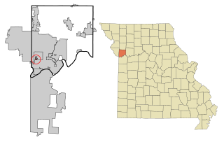
Oaks is a village in Clay County, Missouri, United States. The population was 128 at the 2020 census. It is part of the Kansas City metropolitan area.

<span class="mw-page-title-main">Oakview, Missouri</span> Village in Missouri, United States

Oakview is a village in Clay County, Missouri, United States. The population was 366 at the 2020 census. It is part of the Kansas City metropolitan area.

<span class="mw-page-title-main">Oakwood, Missouri</span> Village in Missouri, United States

Oakwood is a village in Clay County, Missouri, United States. The population was 198 at the 2020 census. It is part of the Kansas City metropolitan area.

<span class="mw-page-title-main">Oakwood Park, Missouri</span> Village in Missouri, United States

Oakwood Park is a village in Clay County, Missouri, United States. The population was 189 at the 2020 census. It is part of the Kansas City metropolitan area.

<span class="mw-page-title-main">Lafayette, Ohio</span> Village in Ohio, United States

Lafayette is a village in Allen County, Ohio, United States. The population was 406 at the 2020 census. It is included in the Lima, Ohio Metropolitan Statistical Area.

<span class="mw-page-title-main">Oakwood, Cuyahoga County, Ohio</span> Village in Ohio, United States

Oakwood is a village in Cuyahoga County, Ohio, United States. The population was 3,572 at the 2020 census. An eastern suburb of Cleveland, it is a part of the Cleveland metropolitan area.

<span class="mw-page-title-main">Antwerp, Ohio</span> Village in Ohio, United States

Antwerp is a village in Paulding County, Ohio, United States, along the Maumee River. The population was 1,676 at the 2020 census.

<span class="mw-page-title-main">Broughton, Ohio</span> Village in Ohio, United States

Broughton is a village in Paulding County, Ohio, United States. The population was 116 at the 2020 census.

<span class="mw-page-title-main">Cecil, Ohio</span> Village in Ohio, United States

Cecil is a village in Paulding County, Ohio, United States. The population was 146 at the 2020 census.

<span class="mw-page-title-main">Grover Hill, Ohio</span> Village in Ohio, United States

Grover Hill is a village in Paulding County, Ohio, United States. The population was 382 at the 2020 census. The village is named after President Grover Cleveland.

<span class="mw-page-title-main">Haviland, Ohio</span> Village in Ohio, United States

Haviland is a village in Paulding County, Ohio, United States. The population was 160 at the 2020 census.

<span class="mw-page-title-main">Latty, Ohio</span> Village in Ohio, United States

Latty is a village in Paulding County, Ohio, United States. The population was 165 at the 2020 census.

<span class="mw-page-title-main">Melrose, Ohio</span> Village in Ohio, United States

Melrose is a village in Paulding County, Ohio, United States. The population was 233 at the 2020 census.

<span class="mw-page-title-main">Paulding, Ohio</span> Village in Ohio, United States

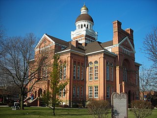
Paulding is a village in and the county seat of Paulding County, Ohio, United States. It is located predominantly in Paulding Township about 64 miles (103 km) southwest of Toledo. The population was 3,555 at the 2020 census.

<span class="mw-page-title-main">Payne, Ohio</span> Village in Ohio, United States

Payne is a village in Paulding County, Ohio, United States. The population was 1,192 at the 2020 census.

<span class="mw-page-title-main">Scott, Ohio</span> Village in Ohio, United States

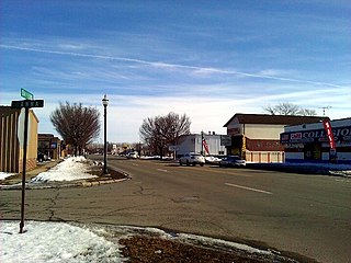
Scott is a village in Paulding and Van Wert counties in the U.S. state of Ohio. The population was 242 at the 2020 census. The Van Wert County portion of Scott is part of the Van Wert Micropolitan Statistical Area.

References

  1. "ArcGIS REST Services Directory". United States Census Bureau. Retrieved September 20, 2022.
  2. 1 2 U.S. Geological Survey Geographic Names Information System: Oakwood, Paulding County, Ohio
  3. 1 2 "U.S. Census website". United States Census Bureau . Retrieved January 31, 2008.
  4. "US Gazetteer files 2010". United States Census Bureau. Archived from the original on January 25, 2012. Retrieved January 6, 2013.
  5. "Census of Population and Housing". Census.gov. Retrieved June 4, 2015.
  6. "U.S. Census website". United States Census Bureau . Retrieved January 6, 2013.
  7. "Main Library & Branches". Paulding County Library. Retrieved March 3, 2018.