Kafue River

Last updated

Kafue
Kafue river02.jpg
Kafue River, Chamufumbu, near Lubungu Pontoon, Zambia
Kafue OSM.svg
The Kafue River Basin
Location
Country Zambia
City Kitwe, Mazabuka, Kafue Town
Physical characteristics
Source 
  locationZambian border with the Democratic Republic of Congo northwest of Kipushi, North-Western Province, Zambia
  coordinates 11°36′S27°12′E / 11.600°S 27.200°E / -11.600; 27.200
  elevation1,350 m (4,430 ft)
Mouth Zambezi
  location
near Chirundu, Southern Province, Zambia
  coordinates
15°56′34″S28°54′51″E / 15.9429°S 28.9143°E / -15.9429; 28.9143
  elevation
410 m (1,350 ft)
Length1,576 km (979 mi)
Basin size155,000 km2 (60,000 sq mi)
Discharge 
  average320 m3/s (11,000 cu ft/s)
Basin features
River system Zambezi


The Kafue River (red) and part of the Zambezi River (blue) Kafue River Course2.png
The Kafue River (red) and part of the Zambezi River (blue)
Kafue river from the Kafue bridge Kafue river as seen from Kafue bridge.jpg
Kafue river from the Kafue bridge

The Kafue River is the longest river lying wholly within Zambia at about 1,576 kilometres (979 mi) long. [1] Its water is used for irrigation and for hydroelectric power. [2] It is the largest tributary of the Zambezi, [3] and of Zambia's principal rivers, it is the most central and the most urban. More than 50% of Zambia's population live in the Kafue River Basin and of these around 65% are urban. [1]

Contents

It has a mean flow rate of 320 m3/s through its lower half, with high seasonal variations. The river discharges 10 km3 per year into the Zambezi River. [4]

Course

Sources

The Kafue River rises at an elevation of 1350 m on the relatively flat plateau just south the border between Zambia and the Democratic Republic of the Congo 120 km north-west of Chingola in the Copperbelt Province. The source of the Kafue River is in the North-western Province of Zambia. The area is Miombo woodland on the Congo-Zambezi watershed, with many branching dambos lying 10 to 20 m lower than the highest ground, producing a very gently undulating topography. The river starts as a trickle from the marshy dambos (the Munyanshi Swamp is a tributary) and with little slope to speed up river flow, it meanders south-eastwards sluggishly and within 50 km has the character of a mature river. The area receives about 1200 mm of rain in the rainy season, and the river's channel soon reaches 100 m wide with a floodplain of fluvial dambos 1–2 km wide. [5]

Through the Copperbelt

Before the river reaches the Copperbelt towns, however, it loses its wide floodplain, the channel narrows to 30–40 m and it meanders less, in a shallow valley only 40 m or so lower than the surrounding plateau. It flows close to the Copperbelt towns of Chililabombwe, Chingola and Mufulira, and through the outskirts of Kitwe. [6] The popular picnic spot the Hippo Pool north of Chingola is protected as a national monument.

In the Copperbelt, water is taken from the river to irrigate small farms and market gardens. At Kitwe it changes course to the south-west and flows through forest and areas of flat rock over which it floods in the wet season, keeping to a channel about 50 m wide in the dry season. [5] [7]

Lukanga Swamp

The river again develops intricate meanders and a maze of channels in a swampy floodplain, with oxbow lakes and lagoons. It flows 20 km west of the permanent part of the Lukanga Swamp which fills a circular depression, and which drains through a channel into the Kafue. The area between the swamp and river is flood plain and when that and surrounding areas are inundated in the rainy season, the combined wetland exceeds 6000 km2. [5] This is the first of the three main wildlife areas of the river, and the least surveyed and protected.

Through Kafue National Park

The character of the river changes again, as it forms a less meandering dry-season channel with sandy banks and islands. Continuing south-west it enters the Kafue National Park, second largest national park in Africa, where it receives its two largest tributaries, the Lunga and Lufupa rivers, also from the north. [6] The Kafue skirts the south-east edge of the Busanga Plain, one of Africa's premier wildlife areas, known for large herds of cape buffalo, zebra and antelope. In the rainy season the Lufupa floods the plain. [8]

Itezhi-Tezhi Gap

Like the upper Zambezi, Okavango and Cuando rivers, the Kafue used to flow south all the way to Lake Makgadikgadi and on to the Limpopo River, but the land in that area was uplifted. A rift valley formed running due east of where the Kafue National Park is now, and the Kafue river eroded a channel called the Itezhi-Tezhi Gap through a ridge of hills about 100 m high, flowing eastwards. The Itezhi-Tezhi Dam was built in 1977 at the gap and now forms a reservoir 50 km long and up to 10 km wide. [8]

Kafue Flats

Further east, the river flows sluggishly across a flat plain called the Kafue Flats (formerly Butwa after the Twa people) and for the third time develops intricate meanders in a maze of swampy channels and lagoons. This time however it also has an immense shallow flood plain which no roads or railways cross, 240 km long and about 50 km wide, [5] flooded to a depth of less than a metre in the rainy season (deeper in some lagoons and permanently swampy areas), and drying out to a clayey black soil in the dry season. The Kafue Flats are the third major wildlife area of the river. Tens of thousands of Kafue Lechwe live on the Kafue Flats and are adapted to wading the flooded areas. This area also has one of the greatest variety and concentrations of birds in the world. The Lochinvar and Blue Lagoon National Parks have been established on the flats. [8]

Around Mazabuka as the river gets closer to the town of Kafue, sugar plantations and other large agricultural estates have been established on the fertile black soil and use water from the river in the dry season. [8]

Kafue Gorge and Dam

Victoria Falls National Park marker Victoria Falls National Park marker.jpg
Victoria Falls National Park marker

The Kafue Flats end at Kafue town and from there, as the rift valley gets deeper, the river drops 550 m over 60 km through the Kafue Gorge. [5] A second dam, the Kafue Gorge Dam, with a smaller reservoir, generates electricity. The lower Zambezi (originally a separate river) cut back through the rift valleys and eventually captured the Kafue. Their confluence is about 20 km north of Chirundu. [6]

Bridges

Railway

See Kafue Railway Bridge for a full account. It was opened in 1906 to connect Kafue with Mazabuka and was originally meant to be part of the Cape to Cairo Railway.

Road

The first road bridge across the Kafue was originally built across the Thames in London during the Second World War. After the war, it was dismantled and installed some 9 km downstream from the railway bridge. Previously, road traffic crossed the river by pontoon.[ citation needed ]

The T3 road crosses the river in-between Chililabombwe and Chingola as well as in the city of Kitwe, both in the Copperbelt Province. The T2 road (Cape to Cairo Road) crosses the river 10 km south of the Kafue town centre. The Lusaka–Mongu Road crosses the river as the Kafue Hook Bridge in the Kafue National Park.

Environmental issues

Pollution

As it flows through the Copperbelt the Kafue River is at great risk of pollution, not just from urban waste but from copper mine tailings. [9] The swampy areas west of the Lukanga Swamp help silt and pollution settle out so that the river becomes clear downstream. A report in April 2002 said: … natural wetlands are quite effective at controlling water pollution from mining in the Copperbelt … Tests show the Kafue to be clean of mining pollutants downstream from the Copperbelt. [10]

In the Kafue flats, the discharge of phosphates in excess fertiliser run-off from commercial farming and the Nakambala Sugar Estate can cause algal blooms and weed growth, reducing fish populations. [4]

Effluent from mining containing cadmium, lead and mercury have degraded the Kafue River [11] Municipal water supply had to be suspended when the Kafue River turned blue due to slurry discharge [12]

Because of its size and geographic location, the Kafue River basin is an ecosystem that provides services and support to communities and industries that have different and sometimes conflicting interests in usage of the river resources. In 1999, the World Wildlife Fund (WWF) initiated dialogue between the Zambian Government, the Zambia Electricity Supply Corporation (ZESCO) and local people to restore a more natural flow pattern to water releases from the Itezhi-Tezhi Dam built on the Kafue River. [13]

This project heavily influenced development of Zambian Government policy on water resources and in February 2010, the Zambian Cabinet approved a revised National Water policy that "aims to improve water resources management by establishing institutional coordination, engaging in modern methods of integrated water resource management while decentralising government policy to address diverse interests within the water sector". [14]

Itezhi-Tezhi and Kafue Gorge Dams

These have had major negative environmental effects on the river [4] — see main article on the Itezhi-Tezhi Dam.

Water for irrigation

Commercial plantations, especially those bordering the Kafue flats take large quantities of water for irrigation. Chief of these is the Nakambala Sugar Estate, which draws in excess of 720,000 m3 per day to irrigate 134.13 square kilometres of land to grow sugar cane. [4]

See also

Related Research Articles

<span class="mw-page-title-main">Kariba Dam</span> Dam in Zambia, Zimbabwe

The Kariba Dam is a double curvature concrete arch dam in the Kariba Gorge of the Zambezi river basin between Zambia and Zimbabwe. The dam stands 128 metres (420 ft) tall and 579 metres (1,900 ft) long. The dam forms Lake Kariba, which extends for 280 kilometres (170 mi) and holds 185 cubic kilometres (150,000,000 acre⋅ft) of water.

<span class="mw-page-title-main">Zambezi</span> Major river in southern Africa

The Zambezi is the fourth-longest river in Africa, the longest east-flowing river in Africa and the largest flowing into the Indian Ocean from Africa. Its drainage basin covers 1,390,000 km2 (540,000 sq mi), slightly less than half of the Nile's. The 2,574 km (1,599 mi) river rises in Zambia and flows through eastern Angola, along the north-eastern border of Namibia and the northern border of Botswana, then along the border between Zambia and Zimbabwe to Mozambique, where it crosses the country to empty into the Indian Ocean.

<span class="mw-page-title-main">Lake Mweru Wantipa</span> Lake and swamp system in northern Zambia

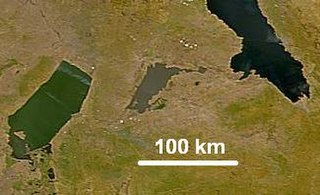
Lake Mweru Wantipa or Mweru-wa-Ntipa meaning "muddy lake" is a lake and swamp system in the Northern Province of Zambia. It has been regarded in the past as something of mystery, displaying fluctuations in water level and salinity which were not entirely explained by variation in rainfall levels; it has been known to dry out almost completely. This is compounded by its remoteness and it not receiving the same attention from geographers and geologists as its larger and more accessible neighbours, Lake Tanganyika, 25 km east, and Lake Mweru, 40 km west, with which its name is sometimes confused.

<span class="mw-page-title-main">Chingola</span> City in Copperbelt Province, Zambia

Chingola is a town in Zambia's Copperbelt Province, the country's copper-mining region, with a population of 216,626. It is the home of Nchanga Copper Mine, a deep-shaft high-grade content copper mining operation, which subsequently led to the development of two open pit operations, Chingola Open Pit and then Nchanga Open Pit.

<span class="mw-page-title-main">Luangwa River</span> River in Zambia

The Luangwa River is one of the major tributaries of the Zambezi River, and one of the four biggest rivers of Zambia. The river generally floods in the rainy season and then falls considerably in the dry season. It is one of the biggest unaltered rivers in Southern Africa and the 52,000 square kilometres (20,000 sq mi) that make up the surrounding valley are home to abundant wildlife.

<span class="mw-page-title-main">Kafue</span> Town in Lusaka Province, Zambia

Kafue is a town on the T2 road in the Lusaka Province of Zambia and it lies on the north bank of the Kafue River, after which it is named. It is the southern gateway to the central Zambian plateau on which Lusaka and the mining towns of Kabwe and the Copperbelt are located.

<span class="mw-page-title-main">Kafue National Park</span> National Park in Zambia

Kafue National Park is the largest national park in Zambia, covering an area of about 22,400 km2. It is the second largest national park in Africa and is home to 152 different species of mammals. There are also 515 bird species, 70 reptile species, 58 species of fish and 36 amphibious species.

<span class="mw-page-title-main">Itezhi-Tezhi Dam</span> Dam in Itezhi-Tezhi, Zambia

The Itezhi-Tezhi Dam on the Kafue River in west-central Zambia was built between 1974 and 1977 at the Itezhi-Tezhi Gap, in a range of hills through which the river had eroded a narrow valley, leading to the broad expanse of the wetlands known as the Kafue Flats. The town of Itezhi-Tezhi is to the east side of the dam.

<span class="mw-page-title-main">Districts of Zambia</span> Districts of the nation of Zambia

The ten provinces of Zambia are divided into a total of 116 districts as of 2018.

Water transport and the many navigable inland waterways in Zambia have a long tradition of practical use except in parts of the south. Since draught animals such as oxen were not heavily used, water transport was usually the only alternative to going on foot until the 19th century. The history and current importance of Zambian waterways, as well as the types of indigenous boats used, provide information on this important aspect of Zambian economy.

The Kafue Flats are a vast area of swamp, open lagoon and seasonally inundated flood-plain on the Kafue River in the Southern, Central and Lusaka provinces of Zambia. They are a shallow flood plain 240 km (150 mi) long and about 50 km (31 mi) wide, flooded to a depth of less than a meter in the rainy season, and drying out to a clayey black soil in the dry season.

<span class="mw-page-title-main">Lukanga Swamp</span> Major wetland in Zambia

Lukanga Swamp is a major wetland in the Central Province of Zambia, about 50 km west of Kabwe. Its permanently swampy area consists of a roughly circular area with a diameter of 40 to 50 km covering 1850 km2, plus roughly 250 km2 in the mouths of and along rivers discharging into it such as the Lukanga River from the north-east, plus another 500 km2 either side of the Kafue River to the west and north-west, making 2600 km2 in total. It contains many lagoons such as Lake Chiposhye and Lake Suye but few large channels, and its average depth is only 1.5 m.

<span class="mw-page-title-main">Wildlife of Zambia</span>

The wildlife of Zambia refers to the natural flora and fauna of Zambia. This article provides an overview, and outline of the main wildlife areas or regions, and compact lists of animals focusing on prevalence and distribution in the country rather than on taxonomy. More specialized articles on particular groups are linked from here.

<span class="mw-page-title-main">Zambezian flooded grasslands</span> Flooded grassland ecoregion in Africa

The Zambezian flooded grasslands is an ecoregion of southern and eastern Africa that is rich in wildlife.

The biomes and ecoregions in the ecology of Zambia are described, listed and mapped here, following the World Wildlife Fund's classification scheme for terrestrial ecoregions, and the WWF freshwater ecoregion classification for rivers, lakes and wetlands. Zambia is in the Zambezian region of the Afrotropical biogeographic realm. Three terrestrial biomes are well represented in the country . The distribution of the biomes and ecoregions is governed mainly by the physical environment, especially climate.

<span class="mw-page-title-main">Barotse Floodplain</span> Major floodplain in Central Africa

The Barotse Floodplain, also known as the Bulozi Plain, Lyondo or the Zambezi Floodplain, is one of Africa's great wetlands, on the Zambezi River in the Western Province of Zambia. It is a designated Ramsar site, regarded as being of high conservation value.

Itezhi-Tezhi is a small town in the Southern Province of Zambia. It is the seat of the Itezhi-Tezhi District. It lies west of the town of Namwala on the border of the Kafue National Park.

<span class="mw-page-title-main">Outline of Zambia</span> Overview of and topical guide to Zambia

The following outline is provided as an overview of and topical guide to Zambia:

Zambia, officially known as the Republic of Zambia, is a landlocked country in Southern Africa. The neighbouring countries are the Democratic Republic of the Congo to the north, Tanzania to the north-east, Malawi to the east, Mozambique, Zimbabwe, Botswana, and Namibia to the south, and Angola to the west. The capital city is Lusaka, located in the southeast of the country. The population is concentrated mainly around the capital and the Copperbelt to the northwest.

References

  1. 1 2 Kambole, Michael (2003). "Managing the water quality of the Kafue River" (PDF). Physics and Chemistry of the Earth. 28 (20–27): 1105–1109. Bibcode:2003PCE....28.1105K. doi:10.1016/j.pce.2003.08.031. Archived from the original (PDF) on 20 August 2014. Retrieved 19 August 2014.
  2. "Kafue River".
  3. The International Bank for Reconstruction and Development/The World Bank (2010). The Zambezi River Basin A Multi-Sector Investment Opportunities Analysis (PDF) (Report).
  4. 1 2 3 4 American Association for the Advancement of Science website: H N. Weza Chabwela & Wanga Mumba, "Integrating Water Conservation and Population Strategies on the Kafue Flats", Report of a Workshop on Water and Population Dynamics, Montreal, Canada, October 1996.
  5. 1 2 3 4 5 Google Earth accessed 1 March 2007.
  6. 1 2 3 Terracarta/International Travel Maps, Vancouver Canada: "Zambia, 2nd edition", 2000
  7. Norrgren, L.; Pettersson, U.; Örn, S.; Bergqvist, P.-A. (1 April 2000). "Environmental Monitoring of the Kafue River, Located in the Copperbelt, Zambia". Archives of Environmental Contamination and Toxicology. 38 (3): 334–341. doi:10.1007/s002449910044. ISSN   0090-4341. PMID   10667931. S2CID   11407966.
  8. 1 2 3 4 Camerapix: "Spectrum Guide to Zambia." Camerapix International Publishing, Nairobi, 1996.
  9. Visit Zambia website: "Kafue Province Campaigners consider suing KCM, Zambian Government over Kafue River Pollution." Accessed 1 March 2007.
  10. Blacksmith Institute website: Zambia Country Report (April 2002) accessed 1 March 2007.
  11. Munnick V. (2007) Solidarity for Environmental Justice in Southern Africa, Report for Ground Work. See also ACTSA, Christian Aid, SCIAF (2007). Undermining Development: Copper Mining in Zambia
  12. Fraser, A. and Lungu, J. 2006: For Whom the Windfalls? Winners and losers in the privatisation of Zambia's copper mines. Civil Society Trade Network of Zambia and the Catholic Centre for Justice, Development and Peace, Zambia
  13. United, Nations. "Innovations for Sustainable Development: Local case studies from Africa" (PDF). United Nations. Retrieved 7 November 2011.
  14. "Global Dimensions of Change in River Basins: Threats Linkages and Adaptation" (PDF). Global Systems Water Project. Retrieved 7 November 2011.