The Twa of the Kafue Flats wetlands of Zambia are one of several fishing and hunter-gatherer castes living in a patron-client relationship with farming Bantu peoples across central and southern Africa.
In Southern Province, where swampy terrain means that large-scale crops cannot be planted near the main rivers, only the Twa fish. [1] They exchange their catch for agricultural produce from their Bantu/village patrons, the Tonga and perhaps the Ila, who build villages at the ecotone on the margins of the floodplain, which they call Butwa "Twa country".
The Kafue Twa have a dark-hut method of fishing unique in Africa. The sides of the river are covered with a thick mat of vegetation. The Twa raise a small reed platform about 3 square at the margin of the vegetation, with a tube in the center down to the water. They cover themselves and the tube with blankets, blocking out light as the adjacent vegetation does and enabling them to see the fish in the river clearly. They then spear the fish with bident and trident spears up to 6 m long, and occasionally longer, depending on the depth of the water. In the 1950s there were several hundred of these platforms raised in the Twa fishing grounds, and catches were reported to be over 100 kg per person per day when the fish were running.
Maho (2009) lists Kafue Twa as a dialect of Ila, Ethnologue of Tonga.

The Zambezi is the fourth-longest river in Africa, the longest east-flowing river in Africa and the largest flowing into the Indian Ocean from Africa. The area of its basin is 1,390,000 square kilometres (540,000 sq mi), slightly less than half of the Nile's. The 2,574-kilometre-long river (1,599 mi) arises in Zambia and flows through eastern Angola, along the north-eastern border of Namibia and the northern border of Botswana, then along the border between Zambia and Zimbabwe to Mozambique, where it crosses the country to empty into the Indian Ocean.

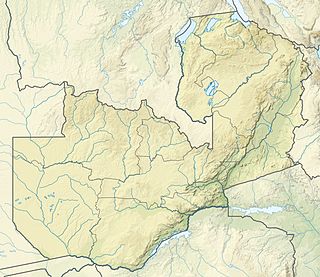
The Kafue River is the longest river lying wholly within Zambia at about 1,600 kilometres (990 mi) long. Its water is used for irrigation and for hydroelectric power. It is the largest tributary of the Zambezi, and of Zambia's principal rivers, it is the most central and the most urban. More than 50% of Zambia's population live in the Kafue River Basin and of these around 65% are urban.

Kafue is a town in the Lusaka Province of Zambia and it lies on the north bank of the Kafue River, after which it is named. It is the southern gateway to the central Zambian plateau on which Lusaka and the mining towns of Kabwe and the Copperbelt are located.area.
The Itezhi-Tezhi Dam on the Kafue River in west-central Zambia was built between 1974 and 1977 at the Itezhi-Tezhi Gap, in a range of hills through which the river had eroded a narrow valley, leading to the broad expanse of the wetlands known as the Kafue Flats. The town of Itezhi-Tezhi rests to the north side of the dam.

Southern Province is one of Zambia's ten provinces, and home to Zambia's premier tourist attraction, Mosi-oa-Tunya, shared with Zimbabwe. The centre of the province, the Southern Plateau, has the largest area of commercial farmland of any Zambian province, and produces most of the maize crop.
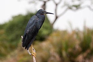
The slaty egret is a small, dark egret. It is one of the species to which the Agreement on the Conservation of African-Eurasian Migratory Waterbirds (AEWA) applies. It is classified as Vulnerable, the biggest threat being habitat loss.
A dambo is a class of complex shallow wetlands in central, southern and eastern Africa, particularly in Zambia and Zimbabwe. They are generally found in higher rainfall flat plateau areas, and have river-like branching forms which in themselves are not very large, but combined add up to a large area. Dambos have been estimated to comprise 12.5% of the area of Zambia. Similar African words include mbuga, matoro (Mashonaland), vlei, fadama (Nigeria), and bolis ; the French bas-fond and German Spültal have also been suggested as referring to similar grassy wetlands.
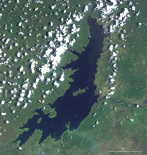
The Kafue Flats are a vast area of swamp, open lagoon and seasonally inundated flood-plain on the Kafue River in the Southern, Central and Lusaka provinces of Zambia. They are a shallow flood plain 240 km long and about 50 km wide, flooded to a depth of less than a meter in the rainy season, and drying out to a clayey black soil in the dry season.

Lukanga Swamp is a major wetland in the Central Province of Zambia, about 50 km west of Kabwe. Its permanently swampy area consists of a roughly circular area with a diameter of 40 to 50 km covering 1850 km2, plus roughly 250 km2 in the mouths of and along rivers discharging into it such as the Lukanga River from the north-east, plus another 500 km2 either side of the Kafue River to the west and north-west, making 2600 km2 in total. It contains many lagoons such as Lake Chiposhye and Lake Suye but few large channels, and its average depth is only 1.5 m.
The Tonga people of Zambia and Zimbabwe are a Bantu ethnic group of southern Zambia and neighbouring northern Zimbabwe, and to a lesser extent, in Mozambique. They are related to the Batoka who are part of the Tokaleya people in the same area, but not to the Tonga people of Malawi. In southern Zambia they are patrons of the Kafue Twa. They differ culturally and linguistically from the Tsonga people of South Africa and southern Mozambique.

The wildlife of Zambia refers to the natural flora and fauna of Zambia. This article provides an overview, and outline of the main wildlife areas or regions, and compact lists of animals focusing on prevalence and distribution in the country rather than on taxonomy. More specialized articles on particular groups are linked from here.

The Zambezian flooded grasslands is an ecoregion of southern and eastern Africa that is rich in wildlife.
The biomes and ecoregions in the ecology of Zambia are described, listed and mapped here, following the World Wildlife Fund's Global 200 classification scheme for terrestrial ecoregions, and the WWF freshwater bioregion classification for rivers, lakes and wetlands. Zambia is in the Afrotropic biogeographic realm of the scheme. Three terrestrial biomes are well represented in the country . The distribution of the biomes and ecoregions is governed mainly by the physical environment, especially climate.

The Barotse Floodplain also known as the Bulozi Plain, Lyondo or the Zambezi Floodplain is one of Africa's great wetlands, on the Zambezi River in the Western Province of Zambia. It is a designated Ramsar site, regarded as being of high conservation value.
The Subiya call themselves Veekuhane and their language is called Chiikuhane. Chiikuhane or Subiya language is classified under Zone K.40 of Bantu languages; a language of northern Botswana, Caprivi Strip, Namibia and Western Zambia up to Victoria Falls .Baumbach (1997:337) classified it as a "Zone k42 Bantu language". Torrend (1931), Shamukuni (1972), and Colson (1996) classified Chiikuhane language under the Bantu Botatwe group; indicating that the language is related to Western Tonga in Zambia and one of the earliest languages of the Zambezi believed to have arrived around Iron Age era. Bantu Botatwe share the distinctive root – tatwe for three. They include Subiya, Tonga, Toka, Leya, Fwe, Twa, Shanjo, Totela, Ila and Lenje. In the Caprivi, Subiya has been classified together with Fwe, Totela and Mbalangwe as one group of languages. Subiya language has a complete grammar book and a textbook containing folklore, superstitions and songs written in French and Subiya in 1896 and 1899 respectively, by the French Missionary Edouard Jacottet. Subiya language also has a complete grammatical sketch written in English and Subiya in the 1960s by Daniel Matengu Shamukuni.

Namwala District is a district of Zambia, located in Southern Province. The capital lies at Namwala. As of the 2000 Zambian Census, the district had a population of 82,810 people.
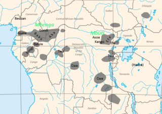
The Congo Pygmies are those "forest people" who have, or recently had, a deep-forest hunter-gatherer economy and a simple, non-hierarchical societal structure based on bands, are of short stature, and have a deep cultural and religious affinity with the Congo forest and live in a generally subservient relationship with agricultural "patrons".

The Twa are a group of African Pygmy peoples, tribes, or castes who live interdependently with agricultural Bantu populations, providing the farming population with game in exchange for agricultural products.
The Twa of the Lukanga Swamp of Zambia are one of several fishing and hunter-gatherer castes living in a patron–client relationship with farming Bantu peoples across central and southern Africa. The Lukanga Twa live primarily among the Lenje, and speak the Lenje language.
Gwisho hot-springs is a rare site for its large quantity of preserved animal and plants remains, located in Lochinvar National Park, Zambia. The site was first excavated by J. Desmond Clark in 1957, who found faunal remains and quartz tools in the western end of the site.