
The Luangwa River is one of the major tributaries of the Zambezi River, and one of the four biggest rivers of Zambia. The river generally floods in the rainy season and then falls considerably in the dry season. It is one of the biggest unaltered rivers in Southern Africa and the 52,000 square kilometres (20,000 sq mi) that make up the surrounding valley are home to abundant wildlife.
The city of Chipata is the administrative centre of the Eastern Province of Zambia and Chipata District. It was declared the 5th city of the country, after Lusaka, Ndola, Kitwe and Livingstone, by President Edgar Lungu on 24 February 2017. The city has undergone rapid economic and infrastructure growth in the years, leading up to city status.

South Luangwa National Park is in eastern Zambia, the southernmost of three national parks in the valley of the Luangwa River. It is a world-renowned wildlife haven which is known to locals simply as "the South Park."Concentrations of game along the meandering Luangwa River and its lagoons are amongst the most intense in Africa. The river teems with hippo and crocodile and provides a lifeline for one of the greatest diversities of habitat and wildlife, supporting more than 60 species of mammals and over 400 species of birds.It marks the end of the Great Rift Valley.

The Great East Road is a major road in Zambia and the main route linking its Eastern Province with the rest of the country. It is also the major link between Zambia and Malawi and between Zambia and northern Mozambique. However, the route does not carry as much traffic as many of the other regional arterial roads and between the main cities it serves, Lusaka and Chipata, it passes through rural and wilderness areas. In Lusaka the road forms the main arterial road for the eastern suburbs. The entire route from Lusaka to Chipata and the Malawi Border Post is designated the T4 Road on Zambia's road network.

Lusaka Province is one of the ten provinces of Zambia. Its capital is Lusaka, which is also the national capital. It is the smallest province in Zambia, with an area of 21,896 km2. Lusaka is also Zambia's most populated and most densely populated province, with a population of 2,191,225 and density of 100 persons per km2 as of 2010. It is the most urban province, with the most doctors and fewest malaria-related incidents. The province is bordered by Zimbabwe and Mozambique, and separated by the Lower Zambezi National Park.
Luambe National Park is located in the Eastern Province of Zambia. The park is situated north-east of the famous South Luangwa National Park, and south of the North Luangwa National Park. Like its neighbours, it is located in the Luangwa River rift valley.

The Mulungushi River in central Zambia is a tributary of the Lunsemfwa River and a part of the Zambezi River basin. It rises on the plateau north-west of Kabwe and flows south-east into the Luangwa Rift Valley where it joins the Lunsemfwa.
Luangwa is a town in Zambia, at the confluence of the Luangwa and Zambezi Rivers, which was called Feira until 1964. It is headquarters of a district of the same name in Lusaka Province.

The wildlife of Zambia refers to the natural flora and fauna of Zambia. This article provides an overview, and outline of the main wildlife areas or regions, and compact lists of animals focusing on prevalence and distribution in the country rather than on taxonomy. More specialized articles on particular groups are linked from here.
The biomes and ecoregions in the ecology of Zambia are described, listed and mapped here, following the World Wildlife Fund's classification scheme for terrestrial ecoregions, and the WWF freshwater ecoregion classification for rivers, lakes and wetlands. Zambia is in the Zambezian region of the Afrotropical biogeographic realm. Three terrestrial biomes are well represented in the country . The distribution of the biomes and ecoregions is governed mainly by the physical environment, especially climate.

The following outline is provided as an overview of and topical guide to Zambia:
The Kunda or Akunda people are an ethnic group of Mambwe District of Eastern Province of Zambia. They number approximately at 160,000 people. They speak Chikunda, a Bantu language closely related to Bisa and Nsenga.
Zambia, officially known as the Republic of Zambia, is a landlocked country in Southern Africa. The neighbouring countries are the Democratic Republic of the Congo to the north, Tanzania to the north-east, Malawi to the east, Mozambique, Zimbabwe, Botswana, and Namibia to the south, and Angola to the west. The capital city is Lusaka, located in the southeast of the country. The population is concentrated mainly around the capital and the Copperbelt to the northwest.

Luangwa is an extinct genus of traversodontid cynodonts. The species Luangwa drysdalli was discovered 1963 in the valley of the Luangwa river in Zambia, Africa. Luangwa lived in the Triassic period 240 Million years ago.

Luangwa District is a district of Zambia, located in Lusaka Province. As of the 2020 Zambian Census, the district had a population of 31,007 people.
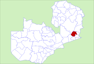
Mambwe District is a district of Zambia, located in Eastern Province. Mambwe District inhabits the Luangwa Valley between the 13th and 14th parallel of south latitude. The Kunda name for this area is the Malambo. The land is bounded on the west by the Luangwa River, on the south by the Lusangazi River and on the north by the Chisitu River. The capital lies at Mambwe named after the great leader of the Kunda people during their migration from the Congo. The District is home to the six Kunda chiefdoms under the Kunda chiefs namely: HRH Senior Chief Nsefu, HRH Chief Malama, HRH Chief Msoro, HRH Chief Mnkhanya, HRH Chief Kakumbi and HRH Chief Jumbe. As of the 2000 Zambian Census, the district had a population of 70,425 people. The District has 15 Wards and one parliamentary constituency called Malambo Constituency.

Mpika District is a district of Zambia, located in Muchinga Province. The capital lies at Mpika. As of the 2000 Zambian Census, the district had a population of 146,196 people. With the Luangwa River forming its eastern border, it has most of the South Luangwa National Park within its boundaries. It also contains the North Luangwa National Park.
Nsenga, also known as Senga, is a Bantu language of Zambia, Malawi and Mozambique, occupying an area on the plateau that forms the watershed between the Zambezi and Luangwa river systems and Western Malawi land overshadowing Kachebere mountain called Mchinji.