

This is a list of rivers in Niger. This list is arranged by drainage basin, with respective tributaries indented under each larger stream's name.
This is a list of rivers in Niger. This list is arranged by drainage basin, with respective tributaries indented under each larger stream's name.
The Dallol Bosso' is one of two major seasonal river valleys in southwest Niger. The Dallol Bosso valley runs from the Azawagh area in the Sahara west and south through the Dosso Region where it reaches the Niger River valley.
Vallée de l'Ahzar is a wadi in West Africa. For most of its course, the wadi forms part of the international boundary between Mali and Niger. It separates Mali's Ménaka Region from the Tahoua and Tillabéri Regions of Niger.
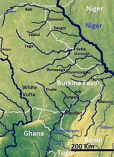
The Tapoa River is a tributary of the Niger River. It flows through the Tapoa Province in Burkina Faso and forms a small part of the international border between Burkina Faso and Niger, after which it flows into the Niger River in southwestern Niger.
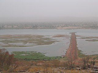
The Niger River is the principal river of West Africa, extending about 4,180 km (2,600 mi). Its drainage basin is 2,117,700 km2 (817,600 sq mi) in area. Its source is in the Guinea Highlands in southeastern Guinea. It runs in a crescent through Mali, Niger, on the border with Benin and then through Nigeria, discharging through a massive delta, known as the Niger Delta or the Oil Rivers, into the Gulf of Guinea in the Atlantic Ocean. The Niger is the third-longest river in Africa, exceeded only by the Nile and the Congo River. Its main tributary is the Benue River.

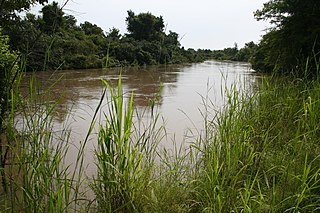
The Goulbi de Maradi is a river in south central Niger and north central Nigeria. Between its source near Katsina in Nigeria, and its end in the Rima River, the Goulbi de Maradi never flows more than 48 kilometres (30 mi) from the Niger–Nigeria border. Though important for agriculture and pastoralism, and flowing through the Niger cities of Maradi, Guidan Roumdji, and Madarounfa, the Goulbi de Maradi is a seasonal river and flows only during the rainy season.
The Mékrou River is a river of Benin, Burkina Faso, and Niger. It flows through the W National Park.

Transport in Niger is composed of the transportation systems and methods used in this landlocked nation, with cities separated by huge uninhabited deserts, mountain ranges, and other natural features. A poor nation, Niger's transport system was little developed during the colonial period (1899–1960), relying upon animal transport, human transport, and limited river transport in the far south west and south east. No railways were constructed in the colonial period, and roads outside the capital remained unpaved. The Niger River is unsuitable for large-scale river transport, as it lacks depth for most of the year and is broken by rapids at many spots. Camel caravan transport was historically important in the Sahara desert and Sahel regions which cover most of the north.

Benue–Congo is a major subdivision of the Niger–Congo language family which covers most of Sub-Saharan Africa. It consists of two main branches:
The W National Park or W Regional Park is a major national park in West Africa around a meander in the River Niger shaped like the letter W. The park includes areas of the three countries Niger, Benin and Burkina Faso, and is governed by the three governments. Until 2008, the implementation of a regional management was supported by the EU-funded project ECOPAS. The three national parks operate under the name W Transborder Park.

The urban community of Dongondoutchi, also nicknamed Doutchi, is located in Niger, about 300 km east of the capital Niamey and 40 km from the Nigerian border. It lies on national route 1 which links the capital to the towns of Maradi and Zinder to the east and the RN25 heading to north to Tahoua, Agadez and Arlit. The limits of the Dogondoutchi district are roughly those of the ancient region of the Arewa. Since 2008, Dogondoutchi is the administrative centre of the surrounding Dogondoutchi department which carries the same name. It is part of the Dosso Region. The population is near 80 000 distributed over the urban centre with near 30 000, 17 villages lying 5 to 30 km from the centre and 5 Fula tribes.
Articles related to Nigeria include:
The Ijawlanguages, also spelt Ịjọ, are the languages spoken by the Ijo people in southern Nigeria.

Say is a department of the Tillabéri Region in Niger. Its capital city is Say, and includes the towns of Guéladjo, Tamou, and Torodi. It abuts the urban Region of Niamey, and lies across the Niger River to the southwest of the capital. It extends to the Burkina Faso border over 60 km to the west, and the northernmost border with Benin in the south. The Say area is today divided between the riverine valley in the east of the Department, and the more sparsely populated areas to the west, which are intercut with a series of eastward flowing tributaries. The Niger river, a broad shallow channel at Niamey and at Say, passes through a series of gorges and cataracts, called the "W" bend for the shape the river takes, in the south of the Say Department. To the west of these rapids lies what is now the W Regional Park, a sparsely populated area historically plagued by insect borne diseases of both humans and cattle. Now a park and tourist attraction, its history as a "no mans land" has made it a refuge for remaining wild animals, as well as several undisturbed archeological sites. From at least the 16th century CE, the Zarma people moved south into this area from the northern plateau around what is now Oullam. The inhabitants at the time were related to the Gourma people, who form most of the population of the northwestern part of the Department today. In the 18th and 19th century, the town of Say was founded by Fulani migrants from the Gao region of modern Mali, with others expanding from what is now northeast Burkina Faso. Between 1810 and the arrival of European writer Heinrich Barth in 1854, Fulani Muslims led by Alfa Mohamed Diobo of Djenné had established the Emirate of Say. The reputation for piety and learning of Mohamed Diobo and his followers helped turn Say from a small river village into a town of 30,000, famed across West Africa as a center of learning.

The Dosso Partial Faunal Reserve is a nature reserve in the southwest Dosso Region of Niger. It is a Partial Faunal Reserve IUCN type IV, established 1 January 1962. The reserve covers 3,065 square kilometres in the mouth of Dallol Bosso valley, a seasonal wash and ancient riverbed running from the Azawagh region, near where it reaches the Niger River valley. It is situated near the W du Niger National Park.

The West African giraffe, Niger giraffe or Nigerien giraffe is a subspecies of the giraffe distinguished by its light colored spots, which is found in the Sahel regions of West Africa.

The Kandadji Dam, when completed, will be a large multipurpose dam on the Niger River. The site is situated near the small town of Kandadji, Tillabéri Department, Tillabéri Region, Niger, 180 km northwest of the capital Niamey. Construction of the dam was begun in August 2008. It is being built by the Haut Commissariat à l'Aménagement de la Vallée du Niger, a public body under the Primer Minister's Office. The dam will generate hydropower and is aimed at controlling the flow of the Niger River, holding water during the dry season to maintain a minimum flow and making downstream irrigation possible. The project is formally named the Kandadji Programme for Ecosystem Regeneration and Niger River Development. In 2008 the dam itself was expected to be completed in 2013. By 2012 the completion date had moved to September 2015. Construction has been slower than expected, with interruptions due to financing problems; as of 2018, completion is expected in 2020.
Arewa is a Hausa language term for north, one of the cardinal directions. Its popular usage in contemporary Nigeria sometimes suggests a northern Nigerian regionalism or proto-nationalism. In both Nigeria and Niger Republic, Arewa is the name of very specific historical entities: in Niger and Nigeria a pre-colonial state, and in Nigeria a small local government region.
Abala, Niger is a village and rural commune in Niger.
Tondikandia is a rural commune in Filingué Department, Tillabéri Region, Niger. Its chief place and administrative center is the town of Damana
Torodi is a small town and a rural commune in Niger. As a rural center, Torodi hosts a large weekly market and the seat of local tribal authority (canton). Torodi is in the Say Department of the Tillaberi Region, which surrounds the national capital, Niamey. Say Department, with its capital at the large Niger River town of Say, abuts Niamey to the southwest and across the river to the west. The town of Torodi lies about 60 km due west of the city of Say and 50 km east of the border with Burkina Faso. Torodi itself lies on a tributary of the Niger, the Gourbi river.
Kouré is a rural community located 60 kilometres (37 mi) east of Niamey, the capital of Niger. The town lies on both sides of the road from Niamey to Dallol Bosso.
The Maouri people are an ethnic group in western Africa. They are one of the major ethnic groups of Niger, and are concentrated around the Dallol Maouri of the Niger River, extending from Matankari, near Niamey, to Gaya. They are a subgroup of the Hausa people, and speak both the Hausa language and the Djerma language. When using the Zarma language, they are known as the Arawa people.
| Wikimedia Commons has media related to Rivers of Niger . |