
Lake Como is a lake of glacial origin in Lombardy, Italy. It has an area of 146 square kilometres (56 sq mi), making it the third-largest lake in Italy, after Lake Garda and Lake Maggiore. At over 400 metres deep, it is one of the deepest lakes in Europe, and the bottom of the lake is more than 200 metres (660 ft) below sea level.
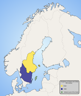
The Gutes were a North Germanic tribe inhabiting the island of Gotland. The ethnonym is related to that of the Goths (Gutans), and both names were originally Proto-Germanic *Gutaniz. Their language is called Gutnish (gutniska). They are one of the progenitor groups of modern Swedes, along with historical Swedes and Geats.
The following tables and lists feature elements of the Cthulhu Mythos, that are often shared between works within that fictional setting.

San Bernardino is a mountainous village in the canton of Grisons in Switzerland. It is the southern entry point to the San Bernardino tunnel, that complemented the road over the San Bernardino Pass in 1967, opening a new all-year-round road to crossing the Alps.

Lagosanto is a comune (municipality) in the Province of Ferrara in the Italian region Emilia-Romagna, located about 70 kilometres (43 mi) northeast of Bologna and about 40 kilometres (25 mi) east of Ferrara.

Albigna Lake is a reservoir in the canton of Graubünden, Switzerland. It is located in the municipality of Vicosoprano at an elevation of 2,163 m on the southwest side of the Bregaglia valley, northeast of Pizzo Cacciabella. The lake has a surface area of 1.13 km². Its outflow, the Albigna River, is a left tributary of the Mera River.
Lago di Viverone is a lake in northern Italy. Named after the town of Viverone, lies at 230 m AMSL between the districts of Biella, Vercelli and Ivrea in the area of morainic hills known as Serra. It has an area of about 6 km2 and a maximum depth of 70 m, and a perimeter of about 10.5 km. The lake is 3,500 m long and 2,600 m wide. The southern and western parts of the lake are rich in vegetation while the north part is built-up and includes hotels, camping sites and beaches.
Lago di Cama is a lake in the Cama valley, a side valley of Val Mesolcina in the Grisons, Switzerland.

Lago di Saoseo is a lake in the Val da Camp, a valley in the Poschiavo region of the Grisons, Switzerland.

Palü Lake is a lake below Piz Palü in the Grisons, Switzerland. Water from Palü Glacier feeds into the lake. In 1926, a dam was built enabling use of the lake as a reservoir.
Lago di Val Viola is a lake in the Grisons, Switzerland. The lake is located near Lago di Saoseo, in the Poschiavo region.

Lägh dal Lunghin is a lake at an elevation of 2484 m, below the peak of Piz Lunghin, in the Graubünden, Switzerland. It is considered the source of the Inn River.

Lägh da Cavloc is a lake near Maloja Pass in the Val Forno, Grisons, Switzerland.

Cima da Lägh is a mountain in the Oberhalbstein Range of the Alps, located on the border between Italy and Switzerland. On its southern side it overlooks the Val Bregaglia.
Lägh da Bitabergh is a lake near Maloja Pass in Val Bregaglia, Grisons, Switzerland.

Lagh Doss is a lake at San Bernardino in the Val Mesolcina of the Grisons, Switzerland. It is located at an elevation of 1652 m. The site is listed in the Federal Inventory of Raised and Transitional Bogs of National Importance.
Findley is a surname of Scottish origin. Spellings include, but are not limited to, Findley, Findlay, Finley, and Finlay. The name is an Anglicized form of the Old Gaelic name Fionnlagh or Fionnlugh which is composed of the elements fionn and lagh: fionn means fair, fair complected or beautiful; lagh from laogh means hero. It has its root in the old Celtic deity Lugh (Lugus).

Khezerlak is a village in Yeylan-e Shomali Rural District, in the Central District of Dehgolan County, Kurdistan Province, Iran. At the 2006 census, its population was 160, in 38 families.

