Related Research Articles

The Gur languages, also known as Central Gur or Mabia, belong to the Niger–Congo languages. They are spoken in the Sahelian and savanna regions of West Africa, namely: in most areas of Burkina Faso, and in south-central Mali, northeastern Ivory Coast, the northern halves of Ghana and Togo, northwestern Benin, and southwestern Niger. A few Gur languages are spoken in Nigeria. Additionally, a single Gur language, Baatonum, is spoken in Benin and in the extreme northwest of Nigeria. Three other single Gur languages, the Tusya, Vyemo and Tiefo languages, are spoken in Burkina Faso. Another unclassified Gur language, Miyobe, is spoken in Benin and Togo. In addition, Kulango, Loma and Lorhon, are spoken in Ghana, Ivory Coast and Burkina Faso. Additionally, a few Mossi speakers are in Senegal, and speakers of the Dagaare language are also found in Cameroon. The Samu languages of Burkina Faso are Gur languages.

Upper Senegal and Niger was a colony in French West Africa, created on 21 October 1904 from colonial Senegambia and Niger by the decree "For the Reorganisation of the general government of French West Africa".
Baoulé, also known as Baule or Bawule, is a language spoken in central and southern Ivory Coast, including in the regions of Lacs, Lagunes, Gôh-Djiboua, Sassandra-Marahoué, Vallée du Bandama, Woroba, and Yamoussoukro, by approximately 4.7 million people. It is a Kwa language of the Central Tano branch, forming a dialect continuum with Anyin and closely related to Nzema and Sehwi. It is the common language of the Baoulé people, the largest ethnic group in Ivory Coast.

Benue–Congo is a major branch of the Volta-Congo languages which covers most of Sub-Saharan Africa.
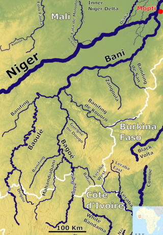
The Bani River is the principal tributary of the Niger River in Mali. The river is formed from the confluence of the Baoulé and Bagoé rivers some 160 km (99 mi) east of Bamako and it merges with the Niger near Mopti. Its length is about 1,100 km (680 mi).
Koulikoro Region is a region in western Mali. It is the second administrative area of Mali and covers an area of 90,120 km2. Its capital is the city of Koulikoro.

The Sélingué Dam is an embankment dam with a gravity section located in the Sikasso Region, on the Sankarani River, one of the affluents of the Niger River. It is an important center of energy production in Mali surpassed only by the Manantali Dam on the Bafing River.

Kayes Region is one of eight first level national subdivisions in Mali called Regions. It is the first administrative area of Mali and covers an area of 120,760 square kilometres or 46,630 square miles. Its capital is the town of Kayes. The province was historically part of the Ghana Empire and the Mali Empire.
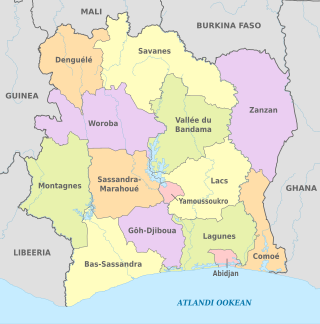
The regions of Ivory Coast are the second-level subdivisions of Ivory Coast. There are 31 regions, and each region is subdivided into two or more departments, the third-level division in Ivory Coast. Two to four regions are combined to make up an autonomous district, the first-level subdivision. The autonomous districts of Abidjan and Yamoussoukro are not divided into regions.

Articles related to Mali include:
The wildlife of Mali, composed of its flora and fauna, is widely varying from the Saharan desert zone to the Sahelian east–west zone, to Mali, a landlocked francophone country in North Africa; large swathes of Mali remain unpopulated but has three sub-equal vegetation zones; the country has Sahara Desert in the north, the Niger River Basin at its center and the Senegal River on the south.
Mahina is a small town and commune in the Cercle of Bafoulabé in the Kayes Region of south-western Mali. The commune includes 24 small villages of which the largest are Mahina, Diallola, Sékodounga and Niakalinssiraya. In the 2009 census the commune had a population of 26,754.
Under UNESCO’s Man and the Biosphere Programme (MAB), there are 70 biosphere reserves recognized as part of the World Network of Biosphere Reserves in African states as of 2016. These are distributed across 28 countries. While biosphere reserves in West African, East African, Central African and Southern African countries are organised in the AfriMAB regional network, biosphere reserves in Northern African countries are organised in the ArabMAB, UNESCO's regional MAB network.
The districts of Ivory Coast are the first-level administrative subdivisions of the country. The districts were created in 2011 in an effort to further decentralise the state.

The Guinea–Mali border is 1,062 km in length and runs from the tripoint with Senegal in the north to the tripoint with Ivory Coast in the south.
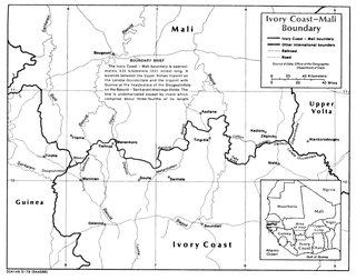
The Ivory Coast–Mali border is 599 km in length and runs from the tripoint with Guinea in the west to the tripoint with Burkina Faso in the east.
References
- Rand McNally, The New International Atlas, 1993.
- GEOnet Names Server