Related Research Articles

The Nile is a major north-flowing river in northeastern Africa. It flows into the Mediterranean Sea. The Nile is the longest river in Africa and has historically been considered the longest river in the world, though this has been contested by research suggesting that the Amazon River is slightly longer. Of the world's major rivers, the Nile is one of the smallest, as measured by annual flow in cubic metres of water. About 6,650 km (4,130 mi) long, its drainage basin covers eleven countries: the Democratic Republic of the Congo, Tanzania, Burundi, Rwanda, Uganda, Kenya, Ethiopia, Eritrea, South Sudan, Republic of the Sudan, and Egypt. In particular, the Nile is the primary water source of Egypt, Sudan and South Sudan. Additionally, the Nile is an important economic river, supporting agriculture and fishing.

Sudan is located in Northeast Africa. It is bordered by Egypt to the north, the Red Sea to the northeast, Eritrea and Ethiopia to the east, South Sudan to the south, the Central African Republic to the southwest, Chad to the west and Libya to the northwest. Sudan is the third largest country in Africa, after Algeria and the Democratic Republic of the Congo. It had been the largest country on the continent until the 2011 independence of South Sudan.
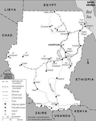
Transport in Sudan during the early 1990s included an extensive railroad system that served the more important populated areas except in the far south, a meager road network, a natural inland waterway—the Nile River and its tributaries—and a national airline that provided both international and domestic service. Complementing this infrastructure was Port Sudan, a major deep-water port on the Red Sea, and a small but modern national merchant marine. Additionally, a pipeline transporting petroleum products extended from the port to Khartoum.
Ethiopia is located in the Horn of Africa. It is bordered by Eritrea to the north, Djibouti and Somalia to the east, Sudan and South Sudan to the west, and Kenya to the south. Ethiopia has a high central plateau that varies from 1,290 to 3,000 m above sea level, with the highest mountain reaching 4,620 m (15,157 ft).
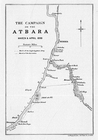
The Atbarah River, also referred to as the Red Nile and / or Black Nile, is a river in northeast Africa. It rises in northwest Ethiopia, approximately 50 km north of Lake Tana and 30 km west of Gondar. It then flows about 805 km (500 mi) to the Nile in north-central Sudan, joining it at the city of Atbarah. The river's tributary, the Tekezé (Setit) River, is perhaps the true upper course of the Atbarah, as the Tekezé follows the longer course prior to the confluence of the two rivers in northeastern Sudan. The Atbarah is the last tributary of the Nile before it reaches the Mediterranean.

Atbara is a city located in River Nile State in northeastern Sudan.

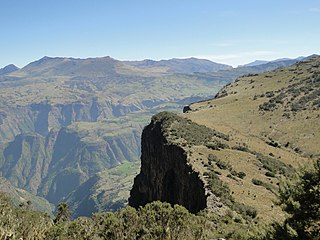
The Tekezé or Täkkäze River, also spelled Takkaze, is a major river of Ethiopia. For part of its course it forms a section of the westernmost border of Ethiopia and Eritrea. The river is also known as the Setit in Eritrea, western Ethiopia, and eastern Sudan. According to materials published by the Ethiopian Central Statistical Agency, the Tekezé River is 608 kilometers (378 mi) long. The canyon which it has created is the deepest in Africa and one of the deepest in the world, at some points having a depth of over 2000 meters.

The Mareb River, or Gash River is a river flowing out of central Eritrea. Its chief importance is defining part of the boundary between Eritrea and Ethiopia, between the point where the Mai Ambassa enters the river at 14°53.6′N37°54.8′E to the confluence of the Balasa with the Mareb at 14°38′N39°1.3′E.

Before the independence of South Sudan, the States of Sudan were subdivided into 133 districts. With the adoption of the Interim National Constitution of Sudan and the Interim Constitution of Southern Sudan, the ten states of South Sudan are, however, now divided into counties. The maps on this page represent the boundaries as they existed in 2006. Current information is available from the Humanitarian Data Exchange.

Bahr al-Arab is a river which flows approximately 800 kilometres (500 mi) through the southwest of Sudan and marks part of its international border with South Sudan. It is part of the Nile river system, being a tributary of Bahr el Ghazal, which is a tributary of the White Nile.

Railway stations in Sudan include:
Ouaddaï Highlands is an area in east of Chad along the border with Sudan. The Ennedi Plateau and the Ouaddaï highlands in the east of Chad complete the image of a gradually sloping basin, which descends towards Lake Chad. There are also central highlands in the Guera region rising to 1,500 m (4,921 ft).

The Sudans is a region in Northeast Africa comprising the sovereign countries of North Sudan and South Sudan. Until 2011, the region was united under a state known as the Republic of the Sudan.
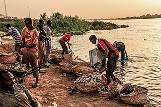
Fishing in Sudan is largely carried out by the traditional sector for subsistence, although a number of small operators also use the country's major reservoirs and the rivers to catch fish for sale locally and in nearby urban centers. There are also some modern fishing ventures, mainly on Lake Nubia and in the Red Sea.
The Adda River is a river of South Sudan, a tributary of the Bahr al-Arab.
Sudan had a modern irrigated agriculture sector totaling about 800,000 hectares in 2010, out of about 84 million hectares that were potentially arable. This was a slight decline from the prior year and well below the more than 2 million hectares of the early 1990s. The Nile and its tributaries were the source of water for 93 percent of irrigated agriculture, and of this, the Blue Nile accounted for about 67 percent. Gravity flow was the main form of irrigation, although pumps served part of the irrigated area.

Darb El Arba'īn is the easternmost of the great north-south Trans-Saharan trade routes. The Darb El Arba'īn route was used to move trade goods, livestock and slaves via a chain of oases from the interior of Africa to portage on the Nile River and thence to the rest of the world.
References
- ↑ Hughes, R.H. & J.S. (1992). A directory of African wetlands. IUCN. p. 233. ISBN 978-2-88032-949-5.