
This is a list of rivers of Nigeria . [1] This list is arranged by drainage basin and from west to east, with respective tributaries indented under each larger stream's name. [2]
This is a list of rivers of Nigeria . [1] This list is arranged by drainage basin and from west to east, with respective tributaries indented under each larger stream's name. [2]
Akwa Ibom State is a state in the South-South geopolitical zone of Nigeria on the east by Cross River State, on the west by Rivers State and Abia State, and on the south by the Atlantic Ocean. The state takes its name from the Qua Iboe River which bisects the state before flowing into the Bight of Bonny. Akwa Ibom was split from Cross River State in 1987 with its capital Uyo and with 31 local government areas.

Osogbo is a city in Nigeria. It became the capital city of Osun State in 1991. Osogbo city seats the Headquarters of both Osogbo Local Government Area and Olorunda Local Government Area. It is some 88 kilometers by road northeast of Ibadan. It is also 108 kilometres (67 mi) by road south of Ilorin and 108 kilometres (67 mi) northwest of Akure. Osogbo shares boundaries with Ikirun, Ilesa, Ede, Egbedore, Ogbomosho and Iragbiji and it is easily accessible from any part of the state because of its central nature. It is about 48 km from Ife, 32 km from Ilesa, 46 km from Iwo, 48 km from Ikire and 46 km from Ila-Orangun; The city had a population of about 500,000 people and an approximate land area of 2875 km2 the postal code of the area is 230.
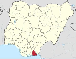
Delta State is a state in the South-South geopolitical zone of Nigeria. Named after the Niger Delta—a large part of which is in the state—the state was formed from the former Bendel State on August 27, 1991. Bordered on the north by Edo State, the east by Anambra and Rivers States, and the south by Bayelsa State across the Niger River for 17 km and the Forçados River for 198 km, while to the west is the Bight of Benin which covers about 160 kilometres of the state's coastline. The State was initially created with 12 local government areas in 1991 which was later extended to 19 and now has 25 local government areas. Asaba as its state capital is located along the River Niger on the northeastern end of the State, while the state's economic centre is the twin cities of Warri and Uvwie

Cross River State is a state in the South-South geopolitical zone of Nigeria. Named for the Cross River, the state was formed from the eastern part of the Eastern Region on 27 May 1967. Its capital is Calabar, it borders to the north through Benue state, to the west through Ebonyi state and Abia state, and to the southwest through Akwa Ibom state, while its eastern border forms part of the national border with Cameroon. Originally known as the South-Eastern State before being renamed in 1976, Cross River state formerly included the area that is now Akwa Ibom state, which became a distinct state in 1987.

Calabar is the capital city of Cross River State, Nigeria. It was originally named Akwa Akpa, in the Efik language. The city is adjacent to the Calabar and Great Kwa rivers and creeks of the Cross River.
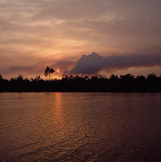
The Niger Delta is the delta of the Niger River sitting directly on the Gulf of Guinea on the Atlantic Ocean in Nigeria. It is located within nine coastal southern Nigerian states, which include: all six states from the South South geopolitical zone, one state (Ondo) from South West geopolitical zone and two states from South East geopolitical zone.
Bayelsa is a state in the South South region of Nigeria, located in the core of the Niger Delta. Bayelsa State was created in 1996 and was carved out from Rivers State, making it one of the newest states in the federation. The capital, Yenagoa, is susceptible to high risk of annual flooding. It shares a boundary with Rivers State to the east and Delta State to the north across the Niger River for 17 km and the Forçados River for 198 km, with the waters of the Atlantic Ocean dominating its southern borders. It has a total area of 10,773 square kilometres (4,159 sq mi). The state comprises eight local government areas: Ekeremor, Kolokuma/Opokuma, Yenagoa, Nembe, Ogbia, Sagbama, Brass and Southern Ijaw. The state is the smallest in Nigeria by population as of the 2006 census. Being in the Niger Delta, Bayelsa State has a riverine and estuarine setting, with bodies of water within the state preventing the development of significant road infrastructure.

Osun State, occasionally known as the State of Osun by the state government, is a state in southwestern Nigeria; bounded to the east by Ekiti and Ondo states, to the north by Kwara State, to the south by Ogun State and to the west by Oyo State. Named for the River Osun—a vital river which flows through the state—the state was formed from the southeast of Oyo State on 27 August 1991 and has its capital as the city of Osogbo.

The University of Calabar is a public university situated in Calabar, Cross River State, Nigeria. It is one of Nigeria's second generation federal universities. The University of Calabar was a campus of the University of Nigeria until 1975. The Vice Chancellor is Florence B. Obi. The post of the DVC (Academic) is held by Angela Oyo Ita, while Grace Eno Nta is the current DVC (Administration).


The Kalabari are a sub-group of the Ijaw people living in the eastern Niger Delta region of Nigeria. Originally, they were known as the Awome. The name Kalabari was derived from their ancestor Perebo Kalabari who was a son of Mein Owei. Their original settlement was spelt as Calabar by the Portuguese which was pronounced Kalabari. This settlement (town) was abandoned as the people moved to other fishing settlements. Portuguese settlers continued to maintain the name Calabari which became surrounded by the Efik people of Duke town. When the British came the word Calabari was pronounced as Calabar (Kalaba) instead of Kalabari. At this time the original Ijoid Kalabaris had moved to a new location which became the new Calabar territory since the old Calabar is occupied by different people. Old Calabar became an Efik town with time which has the name Calabar.
Irepodun/Ifelodun is a Local Government Area of Ekiti State, Nigeria. Irepodun/Ifelodun is predominantly a homogeneous society and carefully populated by Yoruba speaking people of the South West of Nigeria. It has an area of 356 km2 and a population of 129,149 at the 2006 census. The major religions of the people are Christianity and Islam while a percentage of the people are traditional religion worshippers.
Ife South is a Local Government Area in Osun State, Nigeria. Its headquarters are in the town of Ifetedo at 7°11′00″N4°42′00″E.
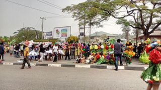
Calabar Carnival is an annual carnival held in Cross River State, Nigeria. The carnival holds every December and was declared by the then governor of Cross River State, Mr. Donald Duke as an activity to mark Christmas celebration yearly. He said his vision for creating the festival was to make Cross-River a home of tourism and hospitality in Nigeria and Africa. The quality of the festival has grown over the years making it Nigeria's biggest carnival and an internationally recognized festival. It used to be a month-long event that began on the 1st of December, until the former governor of the state, Benedict Ayade reduced it to two weeks after he was elected. During the 2017 carnival, Former governor Benedict Ayade said in his speech that the carnival is to showcase Africa as the richest continent and a blessed place where the young ones should be proud to belong. The carnival has always been entertaining and colourful as different competitions take place and huge cash prizes are won. Calabar which is also known by the name Canaan City, is a city in south-eastern Nigeria. Calabar is actually the capital city of Cross River State. Calabar sits adjacent to the Calabar and Great Kwa Rivers and Falls as well as the creeks of the Cross River.
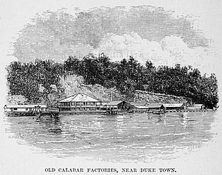
Duke Town, originally known as Atakpa, is an Efik city-state that flourished in the 19th century in what is now southern Nigeria. The City State extended from now Calabar to Bakassi in the east and Oron to the west. Although it is now absorbed into Nigeria, traditional rulers of the state are still recognized. The state occupied what is now the modern city of Calabar.

Cross River is the main river in southeastern Nigeria and gives its name to Cross River State. It originates in Cameroon, where it takes the name of the Manyu River. Although not long by African standards its catchment has high rainfall and it becomes very wide. Over its last 80 kilometres (50 mi) to the sea it flows through swampy rainforest with numerous creeks and forms an inland delta near its confluence with the Calabar River, about 20 kilometres (12 mi) wide and 50 kilometres (31 mi) long between the cities of Oron on the west bank and Calabar, on the east bank, more than 30 kilometres (19 mi) from the open sea. The delta empties into a broad estuary which it shares with a few smaller rivers. At its mouth in the Atlantic Ocean, the estuary is 24 kilometres (15 mi) wide. The eastern side of the estuary is in the neighboring country of Cameroon.
The Calabar River in Cross River State, Nigeria flows from the north past the city of Calabar, joining the larger Cross River about 8 kilometres (5.0 mi) to the south. The river at Calabar forms a natural harbor deep enough for vessels with a draft of 6 metres (20 ft).

Events in the year 2022 in Nigeria.