Related Research Articles

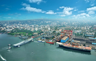
Kochi, formerly known in English as Cochin, is a major port city on the Malabar Coast of India bordering the Laccadive Sea, which is a part of the Arabian Sea. It is part of the district of Ernakulam in the state of Kerala and is often referred to as Ernakulam. Kochi is the most densely populated city in Kerala. As of 2011, it has a corporation limit population of 677,381 within an area of 94.88 km2 and a total urban population of more than of 2.1 million within an area of 440 km2, making it the largest and the most populous metropolitan area in Kerala. Kochi city is also part of the Greater Cochin region and is classified as a Tier-II city by the Government of India. The civic body that governs the city is the Kochi Municipal Corporation, which was constituted in the year 1967, and the statutory bodies that oversee its development are the Greater Cochin Development Authority (GCDA) and the Goshree Islands Development Authority (GIDA).
Ernakulam, is the central portion of the city of Kochi in Kerala, India and has lent its name to the Ernakulam district. Many major establishments, including the Kerala High Court, the office of the Kochi Municipal Corporation are situated here. Ernakulam, which is where a huge part of the commercial activity in Kochi city happen, is known as the commercial capital of Kerala. The Ernakulam Junction is a major railway station of the Indian Railways, and the busiest railway station in Kochi city, the 2nd busiest in Thiruvananthapuram railway division and the 5th busiest in Southern Railways. Initially, Ernakulam was the headquarters of the Ernakulam District but was later shifted to Kakkanad, an eastern region in Kochi. Ernakulam was once the capital of the Kingdom of Cochin. It is located 220 kilometres (137 mi) north - west of the state capital Thiruvananthapuram. The city has served as an incubator for many Malayali entrepreneurs and is a major financial and commercial hub of Kerala. The Kochi Metro's first phase runs through Ernakulam region as well. The second phase aims to connect the CBD with the IT hub of Kakkanad.

Jawaharlal Nehru International Stadium, locally known as Kaloor Stadium, is a multi-purpose international stadium in Kochi, Kerala. The stadium has a capacity of 60,500 spectators. For Indian Super League matches it is restricted to 39,000 as only lower and middle tiers of the stadium are rented out for the matches. The building of a world-class international sports stadium in Kerala was sanctioned by the government of the late Chief minister of Kerala, K. Karunakaran. The stadium was completed ahead of schedule in 1996 by the Greater Cochin Development Authority led by V. Joseph Thomas IPS. The stadium is widely touted to be one of the noisiest football stadiums in the world.

Greater Cochin Development Authority (GCDA) is the statutory body overseeing the development of the city of Kochi in the state of Kerala, India. Head quartered at Kadavanthra, GCDA oversees the development of the major part of Greater Cochin area which consists of the Kochi Municipal Corporation, surrounding municipalities and 21 intervening panchayats covering an area of 632 km2. As of 2001, the area has a population of more than 2.5 million. GCDA is one of the two development authorities in Kochi, the other being GIDA which oversees development in the islands towards west of the Kochi mainland, and north of the harbour, covering a total area of 100 km2.

Ernakulam Town is one of the main railway stations in the city of Kochi, Kerala, India.
Kochi is a major port city in the Indian state of Kerala. The city is widely known as the commercial or economic capital of the state of Kerala.

Palarivattom (MRC) is a region in the city of Kochi in the state of Kerala, India. It is part of the District of Ernakulam. The region makes a four directional intersection at its highway signal point on the Kochi Bypass, which leads to 1) the Vyttila Junction in the South, 2) Kakkanad in its western direction, which is the IT hub of Kochi city, 3) the main junction of Edapally in its north end, which then diverges into the Northern and North-western regions of Kerala such as Kodangallur, Guruvayur, Thrissur, Calicut etc., and 4) eastward towards the central town area of Kochi. The junction is sometimes also referred as pipeline junction. Santhigiri Ashram Ernakulam Branch is in palarivattom.

Kadavanthra is a downtown region and a major commercial centre in Kochi City, close to the city's biggest railway station 'Ernakulam Junction' and Kochi's commercial high street the M.G.Road, in the Indian state of Kerala.

Kangarappady is a suburban region in Kochi, Kerala, India.

Elamkulam is an area in Kadavanthra region in the city of Kochi, state of Kerala, India. Elamkulam falls under Kadavanthra Post Office and Kadavanthra Janamythri Police station. Elamkulam is well facilitated with Metro railway station which works as an extension counter to Kadavanthra metro station to cater to passengers who want to shop at branded outlets like MAX,Trends etc. Elamkulam metro station also privileges direct entry to Radisson Blu Kochi.
Thevara is a place in central Kochi in Kerala, India.
Nettoor is a region in the city of Kochi. It is around 5 km (3.1 mi) from Vytilla Junction and around 8 km (5.0 mi) from Ernakulam Junction Railway Station. Nettoor is located on Panangad Island and is a part of Maradu Municipality.
Vyttila, IPA: [ʋɐjt̺ːilɐ], is an intersection as well as the name of a region in the city of Kochi, in the state of Kerala, India. It is the busiest as well as one of the largest intersections in Kerala. This node intersects the main north–south artery of the state of Kerala, namely, the Kochi Bypass, with three city roads of Kochi viz, the S. A. Road, the Vyttila-Petta Road, and the Thammanam Road.

Kaloor is a downtown region in the city of Kochi, in the state of Kerala, India. It is 2 km from the Ernakulam North Railway Station. Kaloor Junction is also the name of a major intersection in this part of the city, intersecting the two major arteries of downtown Kochi, namely Banerji Road and the Kaloor-Kadavanthra Road. The nearest major intersections are Palarivattom to the east and Lissie Junction to the west.

Mahatma Gandhi Road, popularly known as M. G. Road, is the main artery as well as the commercial high street of the city of Kochi, in the state of Kerala, India. The road lies north-south with its boundaries at the Venduruthy bridge, Thevara in the south, and the Madhava Pharmacy Junction in the north, where it intersects the Banerji Road. The road was earlier part of the NH 47A and was later handed over to Kochi Municipal Corporation. The highway was earlier known as Seventy Feet road. The total distance of the road is 4.5 kilometres (2.8 mi).
Sahodaran Ayyappan Road, popularly known as S.A Road is one of the most important and the second main arterial road of CBD Kochi city ; it is supposed to be the busiest and most congested road in the city of Kochi, which run in east-west direction and the shortest road connecting the two main iconic junctions in the city. The road connects the MG Road in west with Vyttila Junction & Hub in east and continues further as Tripunithura Road that connects to Tripunithura, hence termed as the back bone road of Kochi.
This is a list of areas and neighbourhoods in Cochin by region.

The Kochi Bypass is a segment of NH66(National Highway 66) that bypasses the CBD of the city of Kochi in Kerala, India. The highway stretches 17 km from Edapally in the Ernakulam district to Aroor in Alappuzha district, via. Palarivattom, Vyttila, Kundannoor, Madavana, Kumbalam. The Government of Kerala began the preliminary works in 1973. After a slow progress, it was partially opened for traffic in the beginning years of the 1980s. The section between Edapally and Vyttila had four lanes from the beginning. The rest of the carriageway was also upgraded to different sections of 4 lane, 5lane and 6 lanes by 2010

Panampilly Nagar is a high-end hybrid residential-commercial neighborhood in Kadavanthra region of the city of Kochi, India. It is the most expensive housing colony in Kerala. This place has the highest land value in Kerala after Marine Drive and M.G Road, both in Kochi. It is a busy upmarket residential area in Kadavanthra region just 1 km east of M.G Road, the center of Kochi city.
Kathrikadavu is a region in the city of Kochi, in the state of Kerala, India. It lies almost midway between the two major intersections (junctions) in Kochi, namely Kaloor and Kadavanthra. Kathrikadavu is mainly a residential area, though of late more and more commercial establishments are being set up here.
References
- ↑ "Infrastructure, GCDA". Greater Cochin DevelopmentAuthority. Retrieved 7 December 2010.
- ↑ "Condition of Kaloor-Kadavanthra road deteriorates further". The Hindu . Chennai, India. 3 October 2008. Archived from the original on 8 November 2012.