Karangahake Gorge

Last updated
Karangake Tunnel (more than 1 km long) Modif LR-004219906.jpg
Karangake Tunnel (more than 1 km long)
37°25′25″S175°43′32″E / 37.423676°S 175.725514°E / -37.423676; 175.725514
State Highway 2 through the gorge near Karangahake K-gorge.jpg
State Highway 2 through the gorge near Karangahake
The gorge near Waihi Abaconda qfse Karangahake Gorge.jpg
The gorge near Waihi

The Karangahake Gorge lies between the Coromandel and Kaimai ranges, at the southern end of the Coromandel Peninsula in New Zealand's North Island. A sharply winding canyon, it was formed by the Ohinemuri River. State Highway 2 passes through this gorge between the towns of Paeroa, Waikino and Waihi. This road is the main link between the Waikato region and the Bay of Plenty.

Contents

The East Coast Main Trunk Railway used to run through the gorge until it was bypassed by the Kaimai Deviation - and the Karangahake Gorge section is now a combined walkway and cycleway, part of the Hauraki Rail Trail.

Remains of Woodstock battery Karangahake Gorge Battery Area Photos 02.jpg
Remains of Woodstock battery

There are also several walks and tracks starting at the Karangahake Reserve car park and picnic area; ranging from 30 minutes to over 2 hours.

Mining

"Settlement of Karangahake" including gold mining buildings in centre, circa 1916 Settlement of Karangahake ATLIB 179354.png
"Settlement of Karangahake" including gold mining buildings in centre, circa 1916

The area has a strong connection to mining, and even in the 2010s, a number of companies have been prospecting and mining the area, though with much less visible and invasive methods than were used historically. [1]

The Talisman, Crown and Woodstock stamping battery remains at the lower end of the gorge and are some of the most significant reminders of the time. Their location at the confluence of the Waitawheta River and the Ohinemuri River was chosen to make use of the available water power of the rivers. Mining at the batteries occurred roughly from the 1880s to 1950s, with the most productive years around the turn of the century, [2] when the area produced 60 percent of the total gold from New Zealand. The batteries used to crush the ore from the extensive tunnels mined through the steep local mountainsides of the Waitawheta Gorge, with the Victoria Battery, one of the largest and most advanced at the time. [3]

Walks

At Karangahake, several walks and tracks ranging from 30 minutes to over 2 hours start at the Karangahake Reserve car park and picnic area. [2] One of the most spectacular walks in the area is the "Windows Walk", a loop walk that leads through the old gold mining tunnels of the Talisman Mine, crosses the Waitawheta River over a suspension bridge, and joins the Crown Tramway Track back along the cliffs of the Waitawheta Gorge. [4] [5] The path follows the route of a bush tramway and passes by "windows" in the cliff face at the end of mining tunnels, which were used to tip tailings down into the Waitawheta Gorge. Two of the mining tunnels, which are about 2 metres (7 ft) tall and wide, are safe to enter. They end abruptly after about 50 metres (164 ft) and are home to glowworms and cave weta.

The Woodstock Underground Pumphouse in the Waitawheta Gorge is also still accessible via a short detour from the Crown Tramway Track.

The East Coast Main Trunk Railway used to run through the gorge until it was bypassed by the Kaimai Deviation. The Karangahake Gorge section of the line, including a 1100-metre tunnel, [6] is now a combined walkway and cycleway, part of the Hauraki Rail Trail, and together with the natural sights of the gorge, makes it into a well-visited local tourist attraction. [7] The railhead at the Waikino end of the gorge still exists, preserved as part of the Goldfields Railway to Waihi. [8]

Demographics

Karangahake is defined by Statistics New Zealand as a rural settlement and covers 6.40 km2 (2.47 sq mi) [9] and had an estimated population of 360 as of June 2022, [10] with a population density of 56 people per km2. It is part of the larger Paeroa Rural statistical area. [11]

Historical population
YearPop.±% p.a.
2006321    
2013297−1.10%
2018321+1.57%
Source: [12]

Karangahake had a population of 321 at the 2018 New Zealand census, an increase of 24 people (8.1%) since the 2013 census, and unchanged since the 2006 census. There were 138 households, comprising 165 males and 159 females, giving a sex ratio of 1.04 males per female, with 45 people (14.0%) aged under 15 years, 30 (9.3%) aged 15 to 29, 165 (51.4%) aged 30 to 64, and 75 (23.4%) aged 65 or older.

Ethnicities were 98.1% European/Pākehā, 13.1% Māori, 0.9% Pacific peoples, 0.9% Asian, and 0.9% other ethnicities. People may identify with more than one ethnicity.

Although some people chose not to answer the census's question about religious affiliation, 57.9% had no religion, 27.1% were Christian, 0.9% were Buddhist and 6.5% had other religions.

Of those at least 15 years old, 39 (14.1%) people had a bachelor's or higher degree, and 69 (25.0%) people had no formal qualifications. 12 people (4.3%) earned over $70,000 compared to 17.2% nationally. The employment status of those at least 15 was that 108 (39.1%) people were employed full-time, 39 (14.1%) were part-time, and 18 (6.5%) were unemployed. [12]

Education

Karangahake School is a co-educational state primary school, [13] with a roll of 60 as of April 2023. [14] [15] The school was established in 1889. [16]

See also

Related Research Articles

<span class="mw-page-title-main">Kaimai Range</span> Mountain range in North Island of New Zealand

The Kaimai Range is a mountain range in the North Island of New Zealand. It is part of a series of ranges, with the Coromandel Range to the north and the Mamaku Ranges to the south. The Kaimai Range separates the Waikato in the west from the Bay of Plenty in the east.

<span class="mw-page-title-main">Waihi</span> Town in Waikato region, New Zealand

Waihi is a town in Hauraki District in the North Island of New Zealand, especially notable for its history as a gold mine town.

Paeroa is a town in the Hauraki District of the Waikato Region in the North Island of New Zealand. Located at the base of the Coromandel Peninsula, it is close to the junction of the Waihou River and Ohinemuri River, and is approximately 20 kilometres south of the Firth of Thames.

<span class="mw-page-title-main">Hauraki District</span> Territorial authority district in Waikato, New Zealand

Hauraki District is a territorial authority within the Hauraki region of New Zealand. The seat of the council is at Paeroa.

<span class="mw-page-title-main">Western Bay of Plenty District</span> Territorial authority district in Bay of Plenty, New Zealand

Western Bay of Plenty District is a territorial district within the Bay of Plenty Region of New Zealand. The district envelops Tauranga City by land, and includes Matakana Island, at the entrance to Tauranga Harbour.

<span class="mw-page-title-main">Waihi Beach</span> Town in the Bay of Plenty, New Zealand

Waihi Beach is a coastal town at the western end of the Bay of Plenty in New Zealand's North Island. It lies 10 kilometres to the east of the town of Waihi, at the foot of the Coromandel Peninsula. The main beach is 10 kilometres long. The town had a permanent population of 2,760 as of June 2022.

<span class="mw-page-title-main">Coromandel Range</span> Mountain range in North Island of New Zealand

The Coromandel Range is a volcanic mountain range in the Coromandel Volcanic Zone running the length of the Coromandel Peninsula in the North Island of New Zealand. It is located 60 kilometres (37 mi) east of the city of Auckland, and runs north–south for approximately 110 kilometres. It is at a right angle to the Tararua ranges. The highest point in the range is Mount Moehau, at the northern end of the peninsula within the Moehau Range. There are numerous peaks over 600 metres in height. In pre-European times, the southern Coromandel Range was densely forested by trees such as kauri, mataī and tawa, and was a home for birds such as kererū, tui, kākā and kiwi. Greywacke from the ranges was a source for many stone tools used by Hauraki Māori.

<span class="mw-page-title-main">Ohinemuri River</span> River in New Zealand

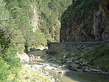
The Ohinemuri River is located in the northern half of New Zealand's North Island, at the base of the Coromandel Peninsula.

<span class="mw-page-title-main">Waikino</span> Settlement in Waikato, New Zealand

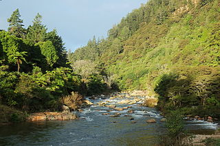
Waikino is a small settlement at the eastern end of a gorge in the North Island of New Zealand alongside the Ohinemuri River, between Waihi and the Karangahake Gorge. The Waikino district lies at the base of the ecologically sensitive Coromandel Peninsula with its subtropical rainforests, steep ravines and fast moving rivers and streams. The cascades of the Owharoa Falls lie just to the south west of the settlement.

<span class="mw-page-title-main">Waikino Music Festival</span>

Waikino Music Festival was a 1977 music and alternatives event held on Bicknell's farm in the Waitawheta Valley between Waikino and Waihi, New Zealand. Between band set ups; solo artists, poets and storytellers, comedians, yoga demonstrations and ravers would entertain, enabling the show to continue without breaks. These ideas were even further developed at the subsequent Nambassa festivals.

<span class="mw-page-title-main">East Coast Main Trunk</span> Railway in New Zealand running between Hamilton and Kawerau

The East Coast Main Trunk (ECMT) is a railway line in the North Island of New Zealand, originally running between Hamilton and Taneatua via Tauranga, connecting the Waikato with the Bay of Plenty. The ECMT now runs between Hamilton and Kawerau, with a branch line to Taneatua from the junction at Hawkens. The line is built to narrow gauge of 1,067 mm, the uniform gauge in New Zealand. It was known as the East Coast Main Trunk Railway until 2011, when the word "Railway" was dropped.

<span class="mw-page-title-main">Goldfields Railway</span>

The Goldfields Railway is a heritage railway that operates between Waihi and Waikino in the Bay of Plenty region of New Zealand's North Island. It operates over a section of track that was part of the East Coast Main Trunk Railway until the Kaimai Tunnel deviation made it redundant in 1978. The Goldfields Railway was formed in 1980 as the Goldfields Steam Train Society to retain a portion of the old mainline and switched to its current name in the mid-nineties.

<span class="mw-page-title-main">Thames Branch</span>

The Thames Branch railway line connected Thames, New Zealand, with Hamilton and was originally part of the East Coast Main Trunk railway. Part of the line between Morrinsville and Waitoa remains open and is in use as the Waitoa Branch line, connecting to the Fonterra Dairy Factory at Waitoa.

<span class="mw-page-title-main">Waitawheta River</span> River in New Zealand

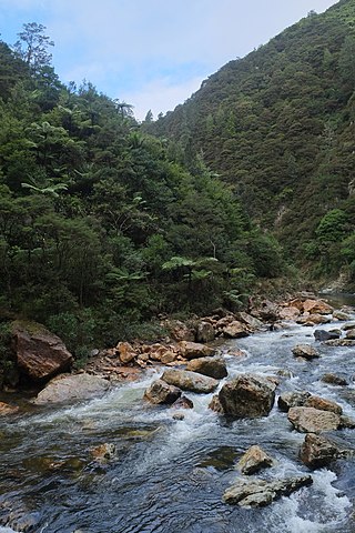
The Waitawheta River is a river of the Waikato Region of New Zealand's North Island. It flows from a point south-east of Mount Te Aroha in the Kaimai Range to the Karangahake Gorge at the foot of the Coromandel Peninsula to reach the Ohinemuri River at Karangahake, five kilometres east of Paeroa.

<span class="mw-page-title-main">Owharoa Falls</span>

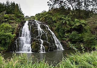
Owharoa Falls is a staircase waterfall in Waikato, New Zealand, located off Waitawheta Road in Karangahake Gorge, near State Highway 2, between Paeroa and Waihi, and close to the small settlement of Waikino.

<span class="mw-page-title-main">Hauraki Rail Trail</span> New Zealand rail trail

The Hauraki Rail Trail is one of the Great Rides of the New Zealand Cycle Trail system, using parts of the abandoned ECMT and Thames Branch railways in the Hauraki Gulf plains and the Coromandel Peninsula.

<span class="mw-page-title-main">Paeroa railway station</span> Defunct railway station in New Zealand

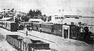
Paeroa railway station is a former railway station in Paeroa; on the Thames Branch, and on the East Coast Main Trunk Railway to Waihi. Between 1895 and 1991 Paeroa had a station at the north end of the town centre, followed by one further north, another back near the town centre and then another over a mile south of the town.

<span class="mw-page-title-main">Waihi-Waikino Gold Tramway</span>

The Waihi-Waikino Gold Tramway was a narrow-gauge railway which ran between gold mines at Waihi and the Victoria Battery at Waikino. Owned by the Waihi Gold Mining Company, it operated from 1897 to 1952. It was the only private railway in New Zealand used by the gold industry.

<span class="mw-page-title-main">Kauaeranga Valley</span> Place in Waikato, New Zealand

Kauaeranga Valley is a valley created by the Kauaeranga River, which flows from the Coromandel Range southwest to the Firth of Thames at Thames, New Zealand in the North Island. It contains the settlement of Kauaeranga on the Coromandel Peninsula. It is located near Thames, in the Thames-Coromandel District in the Waikato region. It covers a land area of 180.51 km2.

Mackaytown is a settlement in the Hauraki District and Waikato region of New Zealand's North Island, located at the north-western end of the Karangahake Gorge just south of Paeroa.

References

  1. Cumming, Geoff (6 March 2010). "Surgical operation for Coromandel". The New Zealand Herald . Retrieved 19 March 2010.
  2. 1 2 "Karangahake Gorge brochure" (PDF). Department of Conservation NZ . Retrieved 2014-08-19.
  3. "Historic Karangahake Gorge". Department of Conservation NZ . Retrieved 2014-08-19.
  4. "Windows Walk: Karangahake Gorge". Department of Conservation NZ . Retrieved 2014-08-19.
  5. Eagles, Jim (5 August 2010). "Karangahake: Windows into darkness". The New Zealand Herald . Retrieved 15 August 2011.
  6. "Karangahake Gorge Historic Walkway". Department of Conservation NZ . Retrieved 2014-08-19.
  7. Clement, Diana (26 April 2011). "Coromandel: Gorge yourself". The New Zealand Herald . Retrieved 15 August 2011.
  8. Wright, Danielle (4 June 2011). "Karangahake Gorge: Middle of the road trip". The New Zealand Herald . Retrieved 15 August 2011.
  9. "ArcGIS Web Application". statsnz.maps.arcgis.com. Retrieved 6 September 2022.
  10. "Subnational population estimates (RC, SA2), by age and sex, at 30 June 1996-2022 (2022 boundaries)". Statistics New Zealand . Retrieved 25 October 2022. (regional councils); "Subnational population estimates (TA, SA2), by age and sex, at 30 June 1996-2022 (2022 boundaries)". Statistics New Zealand . Retrieved 25 October 2022. (territorial authorities); "Subnational population estimates (urban rural), by age and sex, at 30 June 1996-2022 (2022 boundaries)". Statistics New Zealand . Retrieved 25 October 2022. (urban areas)
  11. 2018 Census place summary: Paeroa Rural
  12. 1 2 "Statistical area 1 dataset for 2018 Census". Statistics New Zealand. March 2020. 7010872–7010874.
  13. "Ministry of Education School Profile". educationcounts.govt.nz. Ministry of Education.
  14. "New Zealand Schools Directory". New Zealand Ministry of Education. Retrieved 12 December 2022.
  15. "Education Review Office Report". ero.govt.nz. Education Review Office.
  16. "Karangahake School". Ohinemuri. Retrieved 6 September 2022.