Keane Bridge | |
|---|---|
 Keane Bridge, 2015 | |
| Coordinates | 24°53′15″N91°52′05″E / 24.8876°N 91.8681°E |
| Characteristics | |
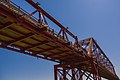
| Total length | 350.52 m (1,150.0 ft) |
| Width | 5.4 m (17.7 ft) |
| History | |
| Opened | 1936 |
| Location | |
 | |
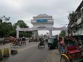
The Keane Bridge is a notable landmark of Sylhet city, Bangladesh. [1] This bridge is called the gateway to Sylhet city.
Contents
After Earl Robert Miller, the ambassador of USA to Bangladesh, visited the bridge and recommended its sole use as a pedestrian bridge, no vehicles are allowed to use the bridge. It is therefore the longest pedestrian bridge in Bangladesh. [2]