
Wantage is a constituency in Oxfordshire represented in the House of Commons of the Parliament of the United Kingdom by Conservative MP David Johnston.
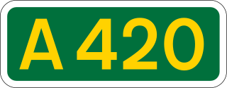
The A420 is a road between Bristol and Oxford in England. Between Swindon and Oxford it is a primary route.
Abingdon was a rural district in the administrative county of Berkshire from 1894 to 1974.
St Helen Without is a civil parish in the Vale of White Horse district in the English county of Oxfordshire. In 1974 it was transferred from Berkshire. It is immediately west of Abingdon and includes the villages of Dry Sandford and Shippon. A large part of the parish is occupied by Dalton Barracks and its associated airfield. According to the 2001 census the parish had a population of 2,623. The parish was created by the Local Government Act 1894, by the division of the parish of Abingdon St. Helen. The part inside Abingdon Municipal Borough became part of Abingdon parish, whilst that part outside became St. Helen Without. It became part of the Abingdon Rural District of Berkshire in 1894, and then part of the Vale of White Horse in Oxfordshire under the Local Government Act 1972.

Kingston Lisle is a village and civil parish in the Vale of White Horse, England, about 4+1⁄2 miles (7 km) west of Wantage and 5 miles (8 km) south-southeast of Faringdon. The parish includes the hamlet of Fawler, about 1⁄2 mile (800 m) west of Kingston Lisle village. The 2011 Census recorded the parish population as 225. Kingston Lisle was part of Berkshire until the 1974 local government boundary changes transferred the Vale of White Horse to Oxfordshire.

Southmoor is a village in the civil parish of Kingston Bagpuize with Southmoor, about 6 miles (9.7 km) west of Abingdon, Oxfordshire. Historically part of Berkshire, the 1974 boundary changes transferred local government to Oxfordshire. Southmoor village is just south of the A420 between Oxford and Swindon.
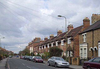
Kingston Road is a road in Oxford, England. It continues north from Walton Street, at the junction with Walton Well Road to the west and St Bernard's Road to the east, running parallel with and to the west of Woodstock Road. Kingston Road is the main road in Walton Manor. At the northern end, there is a staggered junction with Aristotle Lane to the west and Polstead Road to the east. The road continues as Hayfield Road. Southmoor Road and Southmoor Place lead off Kingston Road to the west.

Kingston Bagpuize is a village in the civil parish of Kingston Bagpuize with Southmoor, about 6 miles (10 km) west of Abingdon. It was part of Berkshire, England, until the 1974 boundary changes transferred it to Oxfordshire. The 2011 Census recorded the population of Kingston Bagpuize with Southmoor as 2,349.

The A415 is a British A road which runs from the A4074 at Berinsfield, Oxfordshire (51.6591°N 1.1762°W), to Witney (51.7852°N 1.4965°W), passing through Abingdon, Marcham and Kingston Bagpuize. It crosses the River Thames twice, at Abingdon Bridge and Newbridge.

Longworth is a village and civil parish in the Vale of White Horse, England. The 1974 boundary changes transferred it from Berkshire to Oxfordshire. It lies about 7 miles (11 km) west of Abingdon-on-Thames and 9 miles (14 km) south-west of Oxford. The 2011 Census recorded a population of 566, which was estimated at 570 in 2019. The parish is bounded by the River Thames to the north, the A420 road to the south, and field boundaries to the east and west. The land slopes from the A420 to the river, except at Harrowdown Hill near the north-east corner of the parish, which has a summit of 325 feet (99 m).

Marcham is a village and civil parish about 2 miles (3 km) west of Abingdon, Oxfordshire. The 2011 Census recorded the parish's population as 1,905. The parish includes the hamlets of Cothill 1+3⁄4 miles (2.8 km) east-northeast of the village, and Gozzard's Ford 1+1⁄2 miles (2.4 km) northeast of the village. Frilford and Garford used to be townships of Marcham parish, but are now separate civil parishes. All these parishes were part of Berkshire until the 1974 boundary changes transferred them to Oxfordshire.
Faringdon was a rural district in the administrative county of Berkshire from 1894 to 1974.

Longworth Road is a residential road in Walton Manor, north Oxford, England.
Eaton is a hamlet about 4.5 miles (7 km) west of Oxford and about 5 miles (8 km) northwest of Abingdon. Eaton is in the civil parish of Appleton-with-Eaton, which is traditionally part of Berkshire, and now in the ceremonial county of Oxfordshire.

Ardington and Lockinge are two civil parishes in the Vale of White Horse district, centred about 2 miles (3 km) east of Wantage, Oxfordshire, that share a single parish council. The two parishes were part of Berkshire until 1974 when they were transferred to Oxfordshire.
Fyfield and Tubney is a civil parish in The Vale of White Horse district of Oxfordshire, England. It includes the village of Fyfield which is about 4.5 miles (7 km) west of Abingdon and Tubney, which is about 4 miles (6 km) west of Abingdon. The parish was formed in 1952 when the parish of Fyfield was merged with the parish of Tubney. It was part of Berkshire until the 1974 boundary changes transferred it to Oxfordshire.
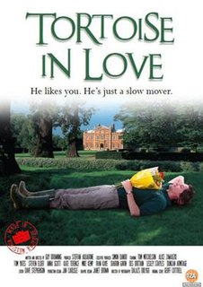
Tortoise in Love is a 2012 British romantic comedy film. The story follows a microbiologist turned stately home gardener who enlists the help of his village in an attempt to woo a Polish au pair he has fallen in love with. First shown at the 2011 Cannes Film Festival, the film received its world premiere at Odeon West End, Leicester Square, the first film to premiere at Leicester Square since its official re-opening. The film made headlines as a result of having its funding entirely crowd sourced from the village of Kingston Bagpuize and the neighbouring village of Southmoor.

