Kisbajom | |
|---|---|
Village | |
 Coat of arms | |
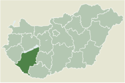 Location of Somogy county in Hungary | |
 Kisbajom Location of Kisbajom | |
| Coordinates: 46°18′16″N17°29′26″E / 46.30455°N 17.49045°E | |
| Country | |
| Region | Southern Transdanubia |
| County | Somogy |
| District | Nagyatád |
| RC Diocese | Kaposvár |
| Area | |
• Total | 13.67 km2 (5.28 sq mi) |
| Population (2017) | |
• Total | 388 [1] |
| • Density | 28.4/km2 (73.5/sq mi) |
| Demonym | kisbajomi |
| Time zone | UTC+1 (CET) |
| • Summer (DST) | UTC+2 (CEST) |
| Postal code | 7542 |
| Area code | (+36) 82 |
| NUTS 3 code | HU232 |
| MP | László Szászfalvi (KDNP) |
Kisbajom is a village in Somogy county, Hungary. The village can be found in a forest area at the end of a dead end road.
Contents
The name of the village literally translated means My Small Problem (Kis+baj+om). However, like nearby Nagybajom ("My Large Problem"), the name derives from the Árpád-era name Baj or Baján, meaning rich.