Kogelbeen Cave

Last updated

The Kogelbeen Cave forms part of eight caves on the dolomitic Ghaap Plateau of the Northern Cape, South Africa. It is commonly known as Kogelbeengrotte in Afrikaans. The cave is located on Kogelbeen Farm in Pixley ka Seme District Municipality. It is the longest known cave in the Northern Cape with a length of 788 meters. The Kogelbeen Cave has a diverse fauna with over 39 species living in five life zones within the cave.

Contents

History

The cave was first described in speleological literature in 1964. The cave is classified as a South African Natural Heritage Site under the South African Natural Heritage programme [1]

Surveys and explorations

Irish and Marais survey

The total cave length was measured at 788 metres (2,585 ft). The cave entrance was measured with a 90 by 30 metres (295 ft × 98 ft) doline which leads to a 30 by 15 metres (98 ft × 49 ft) sinkhole. The floor slopes at a depth of just less than 8 metres (26 ft). The doline walls have some holes; however, the main site of the cave starts at the deepest and southern part of the doline. The dry passage is a short and dusky section above the entrance on two levels, which leads for 70 metres (230 ft) in an eastward direction. There is a collapsing overhang to the north of the cave. The main cave sharply descends to a small chamber which is approximately 22 metres (72 ft). Along the north wall of the main chamber is a small hole in the floor. This hole leads to a narrow and moist passage known as the CO2 passage. In this passage, lethal CO2 levels are reached after penetration of a depth of 43 metres (141 ft). These lethal levels of CO2 prevented further exploration. The main cave continues into a main chamber which is approximately at 31 metres (102 ft). Southeast of the main chamber lies a long passage called the bat passage, which slopes upwards for about 120 metres (390 ft). There are a few minor parallel passages linking with the bat passage. The passage has a very high ceiling which is more prominent towards the end of the passage. Westward of the main chamber lies a small crawlway which leads to a low and wide passage called the water passage. The water passage is filled with numerous shallow seepage pools. The water table is reached at 57 metres (187 ft). [1]

Hitchcock survey

The 1980 Hitchcock survey differs from the Irish & Marais survey with regards to the CO2 passage. Hitchcock penetrated the CO2 passage all the way to the water table, but makes no mention of the lethal carbon dioxide levels. The air composition is described as 'very good'. Hitchcock measured the water table level in the water passage at 53 m unlike the 57 m measured from the Irish and Marais survey. The water level in the CO2 passage is measured at 73 metres (240 ft). [1]

The current lethal CO2 levels make it near impossible to confirm Hitchcock's measurements of the carbon dioxide passage.

Climate

The main chamber has a temperature of 19 °C (66 °F); the temperature rises to 21 °C (70 °F) in the bat passage and ultimately 22 °C (72 °F) in the water passage. The relative humidity in the water passage and the bat passage reaches 100%. The humidity drops to 98% in the main chamber and 80% in the entrance passage. The water temperature of the main pool is 21 °C (70 °F). Subjective commentary on the carbon dioxide levels over time indicate an increase in CO2 over the past two decades. Hitchcock reported no CO2 levels after penetrating both the water passage and the carbon dioxide passage in 1980. Irish and Marais reported high CO2 in the water passage and lethal CO2 presence in the CO2 passage in 1991. The survey in 1997 found the water passage to be even more uncomfortable with the high CO2 composition of the air and the CO2 passage impossible to survey.

Life zones

There are five life zones in the cave that are distinguishable namely:

  1. The entrance zone includes the doline as well as the twilight cave areas (seven taxa)
  2. The dark dry zone includes the dry passage (nine taxa)
  3. The wet zone includes the main passage, water passage and bat passage (twenty four taxa)
  4. The CO2 zone includes the CO2 passage (two taxa)
  5. The aquatic zone includes the groundwater pools and one taxon [1]

Biospeleology

Animals found using the doline and entrance of the Kogelbeen Cave include:

Baboons that are found at the entrance of the Kogelbeen Cave Papio ursinus - cape of good hope.JPG
Baboons that are found at the entrance of the Kogelbeen Cave
Barn Owls found in the cave Barn Owl RWD2.jpg
Barn Owls found in the cave

The doline serves well for moisture-loving creatures who would otherwise not survive in other areas of Kogelbeen. The Kogelbeen cave also functions as an important bat roost being home to three bat species, including the common bent-wing bat with a population of over 60,000, the Geoffroy's horseshoe bat and the Darling's horseshoe bat, with a combined population of about 5000. [2] Other bat species found include:

Common bent-winged bats with a population of over 60,000 in the Kogelbeen Caves Miniopterus scheibersii 01.jpg
Common bent-winged bats with a population of over 60,000 in the Kogelbeen Caves

These bats are mostly found in the main chamber as well as the bat passage. [1] [2] Considering the large population of bats, unexpectedly thin guano deposits are found.

Species that are dependent on the guano deposits include:

Detritivores that feed on older guano deposits include:

Predators in the Kogelbeen Cave include:

Parasites in the Kogelbeen cave include the mite of the Argus species Argasidae, which feed on the birds and bats of the cave.

Aquatic fauna in the cave include stygobiotic amphipod Sternophysinx Basilobata, which is only found from Kogelbeen. [1]

There is a mammal checklist of the species found in the cave at the Bloemfontein National Museum. [3]

Deaths

The community members around the Kogelbeen cave believe that an unspecified person died in the cave. It is believed that there is an unknown disease that exists in the cave. Smith reported that some of the members of his team fell ill due to histoplasmosis. Hitchcock's party used masks as a preventative measure against unknown diseases. No recorded members of the Irish and Marais party were affected by illness from the Kogelbeen cave.

Development potential

Griekwastad publicity association has sought assessments of the cave as a possible tourism area. Factors that result in the cave being unfavourable for tourism include difficulty in movement around the cave, lack of cave formations, unpleasant CO2 conditions in some areas, and threat of disease. Fishing enthusiasts frequently use the areas in the cave for fishing using a man-made outpost structure. Further tourist development would result in a major loss of the bat species, thus threatening the rest of the fauna. [1]

See also

Related Research Articles

<span class="mw-page-title-main">Cave</span> Natural underground space large enough for a human to enter

A cave or cavern is a natural void in the ground, specifically a space large enough for a human to enter. Caves often form by the weathering of rock and often extend deep underground. The word cave can refer to smaller openings such as sea caves, rock shelters, and grottos, that extend a relatively short distance into the rock and they are called exogene caves. Caves which extend further underground than the opening is wide are called endogene caves.

<span class="mw-page-title-main">Lake Nyos</span> Crater lake in the Northwest Region of Cameroon

Lake Nyos is a crater lake in the Northwest Region of Cameroon, located about 315 km (196 mi) northwest of Yaoundé, the capital. Nyos is a deep lake high on the flank of an inactive volcano in the Oku volcanic plain along the Cameroon line of volcanic activity. A volcanic dam impounds the lake waters.

<span class="mw-page-title-main">Travertine</span> Form of limestone deposited by mineral springs

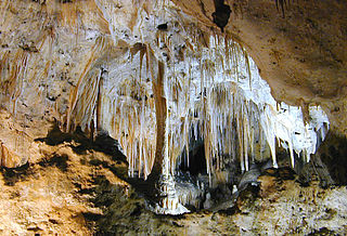
Travertine is a form of terrestrial limestone deposited around mineral springs, especially hot springs. It often has a fibrous or concentric appearance and exists in white, tan, cream-colored, and rusty varieties. It is formed by a process of rapid precipitation of calcium carbonate, often at the mouth of a hot spring or in a limestone cave. In the latter, it can form stalactites, stalagmites, and other speleothems. It is frequently used in Italy and elsewhere as a building material. Similar deposits formed from ambient-temperature water are known as tufa.

<span class="mw-page-title-main">Total organic carbon</span> Concentration of organic carbon in a sample

Total organic carbon (TOC) is an analytical parameter representing the concentration of organic carbon in a sample. TOC determinations are made in a variety of application areas. For example, TOC may be used as a non-specific indicator of water quality, or TOC of source rock may be used as one factor in evaluating a petroleum play. For marine surface sediments average TOC content is 0.5% in the deep ocean, and 2% along the eastern margins.

<span class="mw-page-title-main">Marble Arch Caves</span> Limestone caves in Northern Ireland

The Marble Arch Caves are a series of natural limestone caves located near the village of Florencecourt in County Fermanagh, Northern Ireland. The caves are named after the nearby Marble Arch, a natural limestone arch at the upstream end of Cladagh Glen under which the Cladagh River flows. The caves are formed from three rivers draining off the northern slopes of Cuilcagh mountain, which combine underground to form the Cladagh. On the surface, the river emerges from the largest karst resurgence in Ireland, and one of the largest in the United Kingdom. At 11.5 kilometres (7.1 mi) the Marble Arch Caves form the longest known cave system in Northern Ireland, and the karst is considered to be among the finest in the British Isles.

<span class="mw-page-title-main">Blue hole</span> Marine cavern or sinkhole, open to the surface, in carbonate bedrock

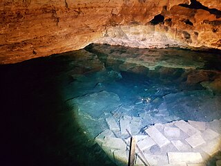
A blue hole is a large marine cavern or sinkhole, which is open to the surface and has developed in a bank or island composed of a carbonate bedrock. Blue holes typically contain tidally influenced water of fresh, marine, or mixed chemistry. They extend below sea level for most of their depth and may provide access to submerged cave passages. Well-known examples are the Dragon Hole and, in the Caribbean, the Great Blue Hole and Dean's Blue Hole.

<span class="mw-page-title-main">Troglofauna</span> Species that lives in caves and similar subterranean environments

Troglofauna are small cave-dwelling animals that have adapted to their dark surroundings. Troglofauna and stygofauna are the two types of subterranean fauna. Both are associated with subterranean environments – troglofauna are associated with caves and spaces above the water table and stygofauna with water. Troglofaunal species include spiders, insects, myriapods and others. Some troglofauna live permanently underground and cannot survive outside the cave environment. Troglofauna adaptations and characteristics include a heightened sense of hearing, touch and smell. Loss of under-used senses is apparent in the lack of pigmentation as well as eyesight in most troglofauna. Troglofauna insects may exhibit a lack of wings and longer appendages.

<span class="mw-page-title-main">Sistema Dos Ojos</span> Flooded cave system at the coast of the Yucatan Peninsula, Mexico

Dos Ojos is part of a flooded cave system located north of Tulum, on the Caribbean coast of the Yucatán Peninsula, in the state of Quintana Roo, Mexico. The exploration of Dos Ojos began in 1987 and still continues. The surveyed extent of the cave system is 82 kilometers (51 mi) and there are 28 known sinkhole entrances, which are locally called cenotes. In January 2018, a connection was found between Sistema Dos Ojos and Sistema Sac Actun. The smaller Dos Ojos became a part of Sac Actun, making the Sistema Sac Actun the longest known underwater cave system in the world.

<span class="mw-page-title-main">Carlsbad Caverns National Park</span> National Park in New Mexico, United States

Carlsbad Caverns National Park is an American national park in the Guadalupe Mountains of southeastern New Mexico. The primary attraction of the park is the show cave Carlsbad Cavern. Visitors to the cave can hike in on their own via the natural entrance or take an elevator from the visitor center.

Speleogenesis is the origin and development of caves, the primary process that determines essential features of the hydrogeology of karst and guides its evolution. It often deals with the development of caves through limestone, caused by the presence of water with carbon dioxide dissolved within it, producing carbonic acid which permits the dissociation of the calcium carbonate in the limestone.

Windsor Great Cave is a 3,000 metres (9,800 ft) long cave in Trelawny Parish on the north coast of Jamaica. The land external to the main entrance is owned by the WWF (UK), and access is often denied by the Windsor Research Centre who act as their proxy.

<span class="mw-page-title-main">Hang Sơn Đoòng</span> Largest cave passage in the world, located near the Laos-Vietnam border

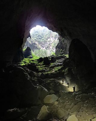
Sơn Đoòng cave, in Phong Nha-Kẻ Bàng National Park, Bố Trạch District, Quảng Bình Province, Vietnam, is one of the world's largest natural caves.

<span class="mw-page-title-main">Photosynthesis system</span> Instruments measuring photosynthetic rates

Photosynthesis systems are electronic scientific instruments designed for non-destructive measurement of photosynthetic rates in the field. Photosynthesis systems are commonly used in agronomic and environmental research, as well as studies of the global carbon cycle.

<span class="mw-page-title-main">Gökgöl Cave</span>

Gökgöl Cave is a show cave in Zonguldak Province, Turkey. It is the fifth biggest cave of the country. It is close to a main highway and is well-decorated with stalactites and stalagmites and attracts many visitors.

<span class="mw-page-title-main">Short Drop Cave - Gavel Pot System</span>

Short Drop Cave and Gavel Pot are different entrances into the same cave system on Leck Fell, in Lancashire, England. The main top entrance, Short Drop Cave, is a small hole in a fenced off shakehole near the main stream sink; Gavel Pot, a window into the system, is a large fenced shakehole some 40-metre (130 ft) deep requiring tackle to descend. There are two other smaller entrances into Short Drop Cave. At its base the system links via a sump with Lost Johns' Cave, and is part of the Three Counties System, an 87 kilometres (54 mi) cave system which spans the borders of Cumbria, Lancashire, and North Yorkshire.

<span class="mw-page-title-main">Stream Passage Pot</span>

Stream Passage Pot is one of the entrances to the Gaping Gill system being located about 320 metres (350 yd) ESE of Gaping Gill Main Shaft. It is a popular and sporting entrance into the system, featuring three well-watered big shafts. It is the highest entrance of the Gaping Gill system, so the full depth of the system, 198 metres (650 ft), is measured from its entrance. It lies within the designated Ingleborough Site of Special Scientific Interest.

Little Blue Lake is a water-filled sinkhole (“cenote”) in the Australian state of South Australia located in the state's south-east in the locality of Mount Schank about 20 kilometres (12 mi) south of the municipal seat of Mount Gambier. It is notable locally as a swimming hole and nationally as a cave diving site. It is managed by the District Council of Grant and has been developed as a recreational and tourism venue.

<span class="mw-page-title-main">Engelbrecht Cave</span> Cave system in South Australia

Engelbrecht Cave is a cave system in the Australian state of South Australia consisting of a sinkhole with two major passages located under the Mount Gambier urban area. It is owned by the local government area of City of Mount Gambier and has been developed as a tourism venue. Its dry extent is notable as a show cave while its water-filled extent is notable as two separate cave diving sites.

<span class="mw-page-title-main">Kitley Show Cave</span> Cave in Devon, England

Kitley Show Cave is a solution cave in Yealmpton, Devon, England. Originally discovered by quarrying, it used to be open to the public as a show cave, but is now closed.

<span class="mw-page-title-main">Total inorganic carbon</span> Sum of the inorganic carbon species

Total inorganic carbon is the sum of the inorganic carbon species.

References

  1. 1 2 3 4 5 6 7 Irish, E.; Marais, J. (February 2012). "Caves of the Northern Cape, South Africa: a baseline study : the Caves". Navorsinge van die Nasionale Museum: Researches of the National Museum. 18 (2): 15–29. hdl:10520/AJA00679208_1439.
  2. 1 2 McNeely, Jeffrey A. (1995). Expanding Partnerships in Conservation. Island Press. p. 257. ISBN   978-1-59726-907-0.
  3. "Mammalogy". National Museum. Bloemfontein. Retrieved 8 October 2021.