Kuala Dungun

Last updated
Kuala Dungun
كوالا دوڠون
Town
Lebuhraya Pantai Timur towards Kuala Dungun Interchange (Exit 851) eastbound in Dungun District, Terengganu 20240224 171555.jpg
Kuala Dungun Interchange
Terengganu location map.svg
Red pog.svg
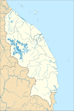
Kuala Dungun
Location in Terengganu
Coordinates: 4°45′22.2″N103°24′33.5″E / 4.756167°N 103.409306°E / 4.756167; 103.409306
CountryFlag of Malaysia.svg  Malaysia
StateFlag of Terengganu.svg  Terengganu
District Dungun
Establishment of town board1953
Establishment of town council1973
Establishment of district council1 January 1981
Municipality status21 August 2008
Time zone UTC+8 (MST)

Kuala Dungun is a mukim and the capital of Dungun District, Terengganu, Malaysia. It is situated midway between Tanjung Jara and Paka. [1]

Contents

Location of Kuala Dungun within Dungun District Map of Dungun District, Terengganu.svg
Location of Kuala Dungun within Dungun District

Etymology

The name "Kuala Dungun" is derived from the local Malay word "kuala", which means the mouth of a river, and "Dungun", which is the name of the district in which the mukim is located.

Geography

Kuala Dungun is located at the mouth of the Dungun River, which flows into the South China Sea. It is bordered by the mukims of Jerangau to the north, Pasir Raja to the east, Hulu Paka to the south, and Paka to the west.

The mukim comprises several villages, including Kampung Baru Kuala Dungun, Kampung Tanjung Jati, Kampung Jabi, Kampung Sura Tengah, and Kampung Pengkalan Ajal.

Demographics

As of 2020, the population of Kuala Dungun is estimated to be around 20,000-30000. The majority of the population are Malays, with Chinese and Indian minorities.

Economy

Kuala Dungun is known for its fishing industry, with many of the locals engaged in fishing and related activities. Agriculture is also an important economic activity in the mukim, with crops such as rubber, palm oil, and coconut being grown.

Transportation

Kuala Dungun exit Lebuhraya Pantai Timur towards Kuala Dungun Interchange (Exit 851) eastbound in Dungun District, Terengganu 20240224 171524.jpg
Kuala Dungun exit

Kuala Dungun is accessible via the East Coast Expressway (ECE), which runs from Johor Bahru in the south to Kota Bharu in the north. The nearest exit to Kuala Dungun is the Kuala Dungun exit (Exit 851).

Related Research Articles

<span class="mw-page-title-main">Belait District</span> District of Brunei

Belait District, or simply Belait, is the largest as well as the westernmost district in Brunei. It has an area of 2,727 square kilometres (1,053 sq mi) and the population of 69,062 as of 2016. The administrative town is Kuala Belait, located at the mouth of the Belait River. The district is commonly associated with the oil and gas industry of the country, mainly concentrated near the town of Seria.

<span class="mw-page-title-main">Batu Pahat District</span> District of Malaysia in Johor

The Batu Pahat District is a district in the state of Johor, Malaysia. It lies southeast of Muar, southwest of Kluang, northwest of Pontian, south of Segamat and Tangkak District. The capital of the district is Bandar Penggaram.

<span class="mw-page-title-main">Pasir Gudang</span> City in Johor, Malaysia

Pasir Gudang is a city in Johor Bahru District, Johor, Malaysia. The main industries are transportation and logistics, shipbuilding, petrochemicals and other heavy industries, and oil palm storage and distribution, which is located in Johor Port and Tanjung Langsat.

<span class="mw-page-title-main">Dungun District</span> District of Malaysia

Dungun is a coastal district of the Malaysian state of Terengganu. Kuala Dungun is the capital of the district. Dungun is made up of eleven 'mukim', or subdistricts: Abang, Besol, Jengai, Jerangau, Kuala Dungun, Kuala Paka, Kumpal, Pasir Raja, Rasau, Sura, and Hulu Paka.

<span class="mw-page-title-main">Mersing</span> Town and district capital in Johor, Malaysia

Mersing is a town, mukim and the capital of Mersing District, Johor, Malaysia.

<span class="mw-page-title-main">Paka, Malaysia</span> Town in Dungun, Terengganu, Malaysia

Paka is a coastal town facing the South China Sea in Dungun District, Terengganu, Malaysia.

<span class="mw-page-title-main">Kemaman District</span> District of Malaysia in Terengganu

Kemaman is a district in Terengganu, Malaysia. Kemaman District is bordered by Dungun District to the north and the state of Pahang to the south and west. It is the southern gateway to the state of Terengganu.

<span class="mw-page-title-main">Setapak</span>

Setapak is a town and mukim straddling both norteastern Kuala Lumpur and Gombak District of Selangor, Malaysia.

<span class="mw-page-title-main">Hulu Terengganu District</span> District of Malaysia in Terengganu

Hulu Terengganu is an interior district of Terengganu, Malaysia. The seat of the district is Kuala Berang, located about 40 km (25 mi) from the state capital, Kuala Terengganu. The local government of this district is Hulu Terengganu District Council.

<span class="mw-page-title-main">Setiu District</span> District of Malaysia in Terengganu

Setiu is one of the districts in Terengganu, Malaysia. This district is bordered by Besut to the north, Hulu Terengganu to the south, and on the east, Kuala Nerus District.

<span class="mw-page-title-main">Majidee Malay Village</span> Village in Johor, Malaysia

Majidee Malay Village is a Malay village located in the city of Johor Bahru, Johor, Malaysia.

<span class="mw-page-title-main">Marang District</span> District of Malaysia in Terengganu

The Marang District is a coastal district in Terengganu, Malaysia. The district seat is the town of Marang. The districts that border Marang are Kuala Terengganu and Kuala Nerus to the north, Hulu Terengganu in the west, while Dungun is in the south. The eastern part of the district is a stretch of coastline facing the South China Sea.

<span class="mw-page-title-main">Mukim Seria</span> Mukim of Brunei

Mukim Seria is a mukim in Belait District, Brunei. It has an area of 169 square kilometres (65 sq mi); the population was 21,214 in 2016. The mukim encompasses Seria, one of the only two towns in the district. It is home to the oil and gas industry of the country.

<span class="mw-page-title-main">Kampong Sungai Teraban</span> Village in Brunei

Kampong Sungai Teraban is a village in Belait District, Brunei, near the district's principal town Kuala Belait. It has an area of 22 square kilometres (8.5 sq mi); the population was 1,082 in 2016. It is one of the administrative villages within Mukim Kuala Belait.

Bruit Island is an island in Daro District, Mukah Division, Sarawak, Malaysia. It is located in the Rejang Delta, 150 km northwest of Kuching. With a population of around 9,342 and an area of 417 square kilometres, it is the second largest island in Malaysia after Banggi Island.

<span class="mw-page-title-main">Mukim Kilanas</span> Mukim of Brunei

Mukim Kilanas is a mukim in Brunei-Muara District, Brunei. The population was 22,492 in 2016.

<span class="mw-page-title-main">Mukim Kota Batu</span> Mukim of Brunei

Mukim Kota Batu is a mukim in Brunei-Muara District, Brunei. The population was 12,935 in 2016. The mukim is home to some of the country's museums and historical sites, in particular in Kota Batu.

<span class="mw-page-title-main">Mukim Bangar</span> Mukim of Brunei

Mukim Bangar is a mukim in Temburong District, Brunei. It has a total area of 113 square kilometres (44 sq mi); the population was 2,112 in 2021. The mukim encompasses Bangar, the district's sole town and administrative centre.

<span class="mw-page-title-main">Mukim Batu Apoi</span> Mukim of Brunei

Mukim Batu Apoi is a mukim in Temburong District, Brunei. It has an area of 222 square kilometres (86 sq mi); as of 2021, the population was 1,355.

Batu Pahat (BP) is a town and capital of Batu Pahat District, Johor, Malaysia. It lies south-east of Muar, south-west of Kluang, north-west of Pontian and south of Segamat. The town area is located inside Simpang Kanan parishes.

References

4°47′N103°26′E / 4.783°N 103.433°E / 4.783; 103.433