
Kelantan is a state in Malaysia. The capital is Kota Bharu and royal seat is Kubang Kerian. The honorific name of the state is Darul Naim . Kelantan is located in the north-eastern corner of the peninsula. Kelantan, which is said to translate as the "Land of Lightning", is an agrarian state with green paddy fields, rustic fishing villages and casuarina-lined beaches. Kelantan is home to some of the most ancient archaeological discoveries in Malaysia, including several prehistoric aboriginal settlements.

Terengganu, formerly spelled Trengganu or Tringganu, is a sultanate and constitutive state of federal Malaysia. The state is also known by its Arabic honorific, Dāru l-Īmān. The coastal city of Kuala Terengganu, which stands at the mouth of the broad Terengganu River, is both the state and royal capital as well as the largest city in Terengganu. There are many islands located close to the coast of Terengganu state, such as Perhentian Islands and Redang Island.

Kuala Terengganu, colloquially referred to as KT, is the administrative, economic and royal capital of the state of Terengganu, Malaysia. Kuala Terengganu is also the capital of Kuala Terengganu District. It is also the only royal capital among the nine royal states of the country that bore its state's name. Kuala Terengganu is located about 440 kilometres northeast of Kuala Lumpur on the East Coast of Peninsular Malaysia. The city is situated at the estuary of Terengganu River, facing the South China Sea.

Lang Tengah Island is an island in Kuala Nerus District, Terengganu, Malaysia. It is connected to the mainland by ferries to Merang.

The Pahang River is a river that flows through the state of Pahang, Malaysia. At 459 km in length, it is the longest river on the Malay Peninsula. The river begins at the confluence of Jelai and Tembeling rivers on the Titiwangsa Mountains and drains into the South China Sea.

Mersing is a town, mukim and the capital of Mersing District, Johor, Malaysia.

Kapas Island is an island in Marang District, Terengganu, Malaysia, with a smaller island, Pulau Gemia, located north of it. It measures roughly 1.5 by 2.5 km. Its name, Pulau Kapas, refers to the island's white beaches. The island has tropical jungle, clear seawater, white sand beaches and coral reefs in the surrounding waters. It is promoted as a "diving and snorkeling paradise". The island is reached by ferry from Marang. Kapas is the location where most of the research on the enigmatic Amphidromus snails is carried out.
Wakaf Tapai is a small town in Marang District, Terengganu, Malaysia.
Paka is a coastal town facing the South China Sea in Dungun District, Terengganu, Malaysia. Paka is now a busy town thriving on oil and gas activity near Kerteh. Paka is more popularly known as the home for the largest power station in Malaysia run by the national power company, Tenaga Nasional. Many foreigners and expatriates serving the energy sector live here. Paka is about 100 km to the south of Kuala Terengganu, the capital city of Terengganu. Currently in the end of year 2013, Paka is listed as the third place in Malaysia with the highest living cost. The World Wide Fund for Nature operates a WWF Turtle Sanctuary nearby Paka.
Kanowit is a town and the capital of a district of the same name, located within the Sibu Division, Sarawak, Malaysia, comprising 2,253.5 square kilometres. As of 2010, Kanowit's population is 28,985. It is built on the mouth of Kanowit River at the bank of Rajang River, approximately 174 kilometers from the coast of South China Sea. It takes 45 minutes to reach the town by land transport and an hour by boat from Sibu. The main ethnic groups are Iban, Chinese, Malay, and Melanau.
Kemaman is a district in Terengganu, Malaysia. Kemaman District is bordered by Dungun District to the north and the state of Pahang to the south and west. It is the southern gateway to the state of Terengganu.
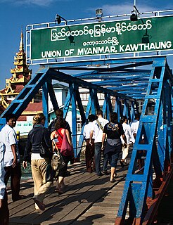
Kawthaung is a town located in the southernmost part of Myanmar, in the Tanintharyi Region. During British rule in Burma between 1824 and 1948, it was known as Victoria Point. As of 2021, it has a population of 57,949.
Chukai, also known by the name of Kemaman Town is a mukim and capital of Kemaman District, Terengganu, Malaysia.
Merchang is a town located in a sub-district of the same name in Marang District, Terengganu, Malaysia. Fishery and agriculture are the main economic activities in Merchang, Marang, Terengganu.

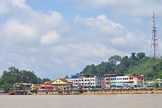
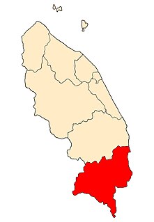
The Marang District is a coastal district in Terengganu, Malaysia. The district seat is the town of Marang. The districts that border Marang are Kuala Terengganu and Kuala Nerus to the north, Hulu Terengganu in the west, while Dungun is in the south. The eastern part of the district is a stretch of coastline facing the South China Sea.

Bukit Payong is a town Marang District, Terengganu, Malaysia.

Kampung Cina, is a Chinatown located in Kuala Terengganu, Terengganu, Malaysia. Kampung Cina is located along Jalan Bandar, in Kuala Terengganu city centre at the river mouth of Terengganu River that empties into the South China Sea. Kampung Cina literally means Chinese Village; it is also called Tn̂g-lâng-pho (唐人坡) or KT's Chinatown by local people. It is one of Southeast Asia's early Chinese settlements and contains stately ancestral homes, temples, townhouses, and business establishments. The town is small but has colourful shophouses along both sides of the road that carries traditional flavour.

The East Coast Rail Link (ECRL) is a standard gauge double-track railway link infrastructure project connecting Port Klang on the Straits of Malacca to Kota Bharu in northeast Peninsular Malaysia, connecting the East Coast Economic Region states of Pahang, Terengganu and Kelantan to one another, and to the Central Region of the Peninsular's west coast.

The Kuala Terengganu District is a district in the state of Terengganu, Malaysia. It covers an area of 210.21 square kilometres, and had a population of 343,284 at the 2010 Census. The district is bordered by Terengganu River which separates Kuala Nerus District in the north and west, Marang District in the south and South China Sea in the east. The capital of this district is Kuala Terengganu.


