
The Coast Mountains are a major mountain range in the Pacific Coast Ranges of western North America, extending from southwestern Yukon through the Alaska Panhandle and virtually all of the Coast of British Columbia south to the Fraser River. The mountain range's name derives from its proximity to the sea coast, and it is often referred to as the Coast Range. The range includes volcanic and non-volcanic mountains and the extensive ice fields of the Pacific and Boundary Ranges, and the northern end of the volcanic system known as the Cascade Volcanoes. The Coast Mountains are part of a larger mountain system called the Pacific Coast Ranges or the Pacific Mountain System, which includes the Cascade Range, the Insular Mountains, the Olympic Mountains, the Oregon Coast Range, the California Coast Ranges, the Saint Elias Mountains and the Chugach Mountains. The Coast Mountains are also part of the American Cordillera—a Spanish term for an extensive chain of mountain ranges—that consists of an almost continuous sequence of mountain ranges that form the western backbone of North America, Central America, South America and Antarctica.

The Ring of Fire is a region around much of the rim of the Pacific Ocean where many volcanic eruptions and earthquakes occur. The Ring of Fire is a horseshoe-shaped belt about 40,000 km (25,000 mi) long and up to about 500 km (310 mi) wide.

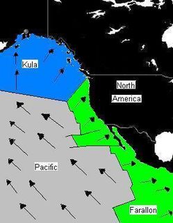
The Farallon Plate was an ancient oceanic plate. It formed one of the three main plates of Panthalassa, alongside the Phoenix Plate and Izanagi Plate, which were connected by a triple junction. The Farallon Plate began subducting under the west coast of the North American Plate—then located in modern Utah—as Pangaea broke apart and after the formation of the Pacific Plate at the centre of the triple junction during the Early Jurassic. It is named for the Farallon Islands, which are located just west of San Francisco, California.
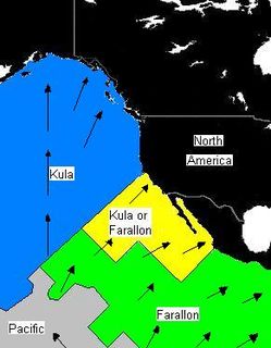
The Kula Plate was an oceanic tectonic plate under the northern Pacific Ocean south of the Near Islands segment of the Aleutian Islands. It has been subducted under the North American Plate at the Aleutian Trench, being replaced by the Pacific Plate.

The Juan de Fuca Ridge is a mid-ocean spreading center and divergent plate boundary located off the coast of the Pacific Northwest region of North America. The ridge separates the Pacific Plate to the west and the Juan de Fuca Plate to the east. It runs generally northward, with a length of approximately 500 kilometres (310 mi). The ridge is a section of what remains from the larger Pacific-Farallon Ridge which used to be the primary spreading center of this region, driving the Farallon Plate underneath the North American Plate through the process of plate tectonics. Today, the Juan de Fuca Ridge pushes the Juan de Fuca Plate underneath the North American plate, forming the Cascadia Subduction Zone.

Volcanic activity is a major part of the geology of Canada and is characterized by many types of volcanic landform, including lava flows, volcanic plateaus, lava domes, cinder cones, stratovolcanoes, shield volcanoes, submarine volcanoes, calderas, diatremes, and maars, along with less common volcanic forms such as tuyas and subglacial mounds.

The geology of the Pacific Northwest includes the composition, structure, physical properties and the processes that shape the Pacific Northwest region of North America. The region is part of the Ring of Fire: the subduction of the Pacific and Farallon Plates under the North American Plate is responsible for many of the area's scenic features as well as some of its hazards, such as volcanoes, earthquakes, and landslides.
The Caribbean large igneous province (CLIP) consists of a major flood basalt, which created this large igneous province (LIP). It is the source of the current large eastern Pacific oceanic plateau, of which the Caribbean-Colombian oceanic plateau is the tectonized remnant. The deeper levels of the plateau have been exposed on its margins at the North and South American plates. The volcanism took place between 139 and 69 million years ago, with the majority of activity appearing to lie between 95 and 88 Ma. The plateau volume has been estimated as on the order of 4 x 10⁶ km³. It has been linked to the Galápagos hotspot.
The Galápagos hotspot is a volcanic hotspot in the East Pacific Ocean responsible for the creation of the Galápagos Islands as well as three major aseismic ridge systems, Carnegie, Cocos and Malpelo which are on two tectonic plates. The hotspot is located near the Equator on the Nazca Plate not far from the divergent plate boundary with the Cocos Plate. The tectonic setting of the hotspot is complicated by the Galapagos Triple Junction of the Nazca and Cocos plates with the Pacific Plate. The movement of the plates over the hotspot is determined not solely by the spreading along the ridge but also by the relative motion between the Pacific Plate and the Cocos and Nazca Plates.

Bowie Seamount is a large submarine volcano in the northeastern Pacific Ocean, located 180 km (110 mi) west of Haida Gwaii, British Columbia, Canada.
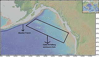
The Cobb-Eickelberg seamount chain is a range of undersea mountains formed by volcanic activity of the Cobb hotspot located in the Pacific Ocean. The seamount chain extends to the southeast on the Pacific Plate, beginning at the Aleutian Trench and terminating at Axial Seamount, located on the Juan de Fuca Ridge. The seamount chain is spread over a vast length of approximately 1800 km. The location of the Cobb hotspot that gives rise to these seamounts is 46° N—130° W. The Pacific plate is moving to the northwest over the hotspot, causing the seamounts in the chain to decrease in age to the southeast. Axial is the youngest seamount and is located approximately 480 km west of Cannon Beach, Oregon. The most studied seamounts that make up this chain are Axial, Brown Bear, Cobb, and Patton seamounts. There are many other seamounts in this chain which have not been explored.
The Pacific-Farallon Ridge was a spreading ridge during the Late Cretaceous that extended 10,000 km in length and separated the Pacific Plate to the west and the Farallon Plate to the east. It ran south from the Pacific-Farallon-Kula triple junction at 51°N to the Pacific-Farallon-Antarctic triple junction at 43°S. As the Farallon Plate subducted obliquely under the North American Plate, the Pacific-Farallon Ridge approached and eventually made contact with the North American Plate about 30 million years ago. On average, this ridge had an equatorial spreading rate of 13.5 cm per year until its eventual collision with the North American Plate. In present day, the Pacific-Farallon Ridge no longer formally exists since the Farallon Plate has been broken up or subducted beneath the North American Plate, and the ridge has segmented, having been mostly subducted as well. The most notable remnant of the Pacific-Farallon Ridge is the 4000 km Pacific-Nazca segment of the East Pacific Rise.
The Pacific-Kula Ridge is a former mid-ocean ridge that existed between the Pacific and Kula plates in the Pacific Ocean during the Paleogene period. Its appearance was in an east-west direction and the Hawaiian-Emperor seamount chain had its attribution with the ridge. The Pacific-Kula Ridge lay south of the Hawaii hotspot around 80 million years ago, moving northward relative to the hotspot.

The Coast Range Arc was a large volcanic arc system, extending from northern Washington through British Columbia and the Alaska Panhandle to southwestern Yukon. The Coast Range Arc lies along the western margin of the North American Plate in the Pacific Northwest of western North America. Although taking its name from the Coast Mountains, this term is a geologic grouping rather than a geographic one, and the Coast Range Arc extended south into the High Cascades of the Cascade Range, past the Fraser River which is the northward limit of the Cascade Range proper.
This is a list of articles related to plate tectonics and tectonic plates.
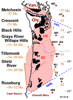
Siletzia is a massive formation of early to middle Eocene epoch marine basalts and interbedded sediments in the forearc of the Cascadia subduction zone, on the west coast of North America. It forms the basement rock under western Oregon and Washington and the southern tip of Vancouver Island. It is now fragmented into the Siletz and Crescent terranes.

The Pacific Ocean evolved in the Mesozoic from the Panthalassic Ocean, which had formed when Rodinia rifted apart around 750 Ma. The first ocean floor which is part of the current Pacific Plate began 160 Ma to the west of the central Pacific and subsequently developed into the largest oceanic plate on Earth.
Foundation Seamounts are a series of seamounts in the southern Pacific Ocean. Discovered in 1992, these seamounts form a 1,350 kilometres (840 mi) long chain which starts from the Pacific-Antarctic Ridge. Some of these seamounts may have once emerged from the ocean.

Musicians Seamounts are a chain of seamounts in the Pacific Ocean, north of the Hawaiian Ridge. There are about 65 seamounts, some of which are named after musicians. These seamounts exist in two chains, one of which has been attributed to a probably now-extinct hotspot called the Euterpe hotspot. Others may have formed in response to plate tectonics associated with the boundary between the Pacific Plate and the former Farallon Plate.
Steeple Rock is a 200 feet (61 m) basalt pillar in the Olympic Mountains, and is located in Clallam County of Washington state. It sets next to the Obstruction Point Road on Hurricane Ridge within Olympic National Park. It's situated midway between Eagle Point and the Hurricane Ridge Visitor Center. Precipitation runoff drains into tributaries of the Elwha River and Morse Creek, thence into the Strait of Juan de Fuca.

