
The North American plate is a tectonic plate containing most of North America, Cuba, the Bahamas, extreme northeastern Asia, and parts of Iceland and the Azores. With an area of 76 million km2 (29 million sq mi), it is the Earth's second largest tectonic plate, behind the Pacific plate.

The African plate, also known as the Nubian plate, is a major tectonic plate that includes much of the continent of Africa and the adjacent oceanic crust to the west and south. It is bounded by the North American plate and South American plate to the west ; the Arabian plate and Somali plate to the east; the Eurasian plate, Aegean Sea plate and Anatolian plate to the north; and the Antarctic plate to the south.

A triple junction is the point where the boundaries of three tectonic plates meet. At the triple junction each of the three boundaries will be one of three types – a ridge (R), trench (T) or transform fault (F) – and triple junctions can be described according to the types of plate margin that meet at them. Of the ten possible types of triple junctions only a few are stable through time. The meeting of four or more plates is also theoretically possible, but junctions will only exist instantaneously.
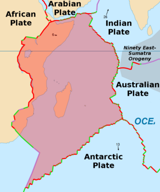
The Somali plate is a minor tectonic plate which straddles the Equator in the Eastern Hemisphere. It is currently in the process of separating from the African plate along the East African Rift Valley. It is approximately centered on the island of Madagascar and includes about half of the east coast of Africa, from the Gulf of Aden in the north through the East African Rift Valley. The southern boundary with the Nubian–African plate is a diffuse plate boundary consisting of the Lwandle plate.

A mid-ocean ridge (MOR) is a seafloor mountain system formed by plate tectonics. It typically has a depth of about 2,600 meters (8,500 ft) and rises about 2,000 meters (6,600 ft) above the deepest portion of an ocean basin. This feature is where seafloor spreading takes place along a divergent plate boundary. The rate of seafloor spreading determines the morphology of the crest of the mid-ocean ridge and its width in an ocean basin.
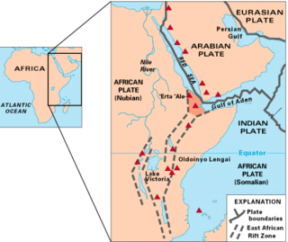
The East African Rift (EAR) or East African Rift System (EARS) is an active continental rift zone in East Africa. The EAR began developing around the onset of the Miocene, 22–25 million years ago. It was formerly considered to be part of a larger Great Rift Valley that extended north to Asia Minor.
The Afar Triangle is a geological depression caused by the Afar triple junction, which is part of the Great Rift Valley in East Africa. The region has disclosed fossil specimens of the very earliest hominins; that is, the earliest of the human clade, and it is thought by some paleontologists to be the cradle of the evolution of humans. The Depression overlaps the borders of Eritrea, Djibouti and the entire Afar Region of Ethiopia; and it contains the lowest point in Africa, Lake Assal, Djibouti, at 155 m (509 ft) below sea level.
The Easter plate is a tectonic microplate located to the west of Easter Island off the west coast of South America in the middle of the Pacific Ocean, bordering the Nazca plate to the east and the Pacific plate to the west. It was discovered from looking at earthquake distributions that were offset from the previously perceived Nazca-Pacific Divergent boundary. This young plate is 5.25 million years old and is considered a microplate because it is small with an area of approximately 160,000 square kilometres (62,000 sq mi). Seafloor spreading along the Easter microplate's borders have some of the highest global rates, ranging from 50 to 140 millimetres /yr.

The Terceira Rift is a geological rift located amidst the Azores islands in the Atlantic Ocean. It runs between the Azores triple junction to the west and the Azores–Gibraltar Transform Fault to the southeast. It separates the Eurasian plate to the north from the African plate to the south. The Terceira Rift is named for Terceira Island through which it passes. It crosses Terceira Island as a prominent ESE-WNW fissure zone.
The Afar Triple Junction is located along a divergent plate boundary dividing the Nubian, Somali, and Arabian plates. This area is considered a present-day example of continental rifting leading to seafloor spreading and producing an oceanic basin. Here, the Red Sea Rift meets the Aden Ridge and the East African Rift. The latter extends a total of 6,500 kilometers (4,000 mi) from the Afar Triangle to Mozambique.

The Red Sea Rift is a mid-ocean ridge between two tectonic plates, the African plate and the Arabian plate. It extends from the Dead Sea Transform fault system, and ends at an intersection with the Aden Ridge and the East African Rift, forming the Afar Triple Junction in the Afar Depression of the Horn of Africa.

The Owen Fracture Zone (OFZ), though misnamed as a fracture zone, is a transform fault in the northwest Indian Ocean that separates the Arabian and African plates from the Indian plate. Extending north-northeast from where the Carlsberg Ridge meets the Sheba ridge in the south to the Makran Subduction Zone in the north, it represents the port side of the northward motion of the Indian subcontinent during the Late Cretaceous–Palaeogene break-up of Gondwana. Slip along the Owen Fracture Zone is occurring at 2 mm (0.079 in)/yr, the slowest rate on Earth, which means the Arabian plate moves northward faster than the Indian plate.
The Aden–Owen–Carlsberg triple junction (AOC), also known as the Arabia–India–Somalia triple junction, is a triple junction that connects the Aden Ridge, Owen Fracture Zone, and Carlsberg Ridge in the northwest Indian Ocean. It has been described as one of only three RRF (ridge–ridge–fault) triple junctions on Earth, besides the Azores triple junction and Chile triple junction. However, because the fault arm of such unstable triple junctions tend to evolve into a spreading centre, all three cases have quickly evolved into stable RRR triple junctions.

The Central Indian Ridge (CIR) is a north–south-trending mid-ocean ridge in the western Indian Ocean.

The Rodrigues triple junction (RTJ), also known as the central Indian [Ocean] triple junction (CITJ) is a geologic triple junction in the southern Indian Ocean where three tectonic plates meet: the African plate, the Indo-Australian plate, and the Antarctic plate. The triple junction is named for the island of Rodrigues which lies 1,000 km (620 mi) north-west of it.

The Southwest Indian Ridge (SWIR) is a mid-ocean ridge located along the floors of the south-west Indian Ocean and south-east Atlantic Ocean. A divergent tectonic plate boundary separating the Somali plate to the north from the Antarctic plate to the south, the SWIR is characterised by ultra-slow spreading rates (only exceeding those of the Gakkel Ridge in the Arctic) combined with a fast lengthening of its axis between the two flanking triple junctions, Rodrigues (20°30′S70°00′E) in the Indian Ocean and Bouvet (54°17′S1°5′W) in the Atlantic Ocean.

The Lwandle plate is one of three tectonic microplates, along with the Rovuma plate and Victoria plate, that make up the African plate with the Somali plate and the Nubian plate. Its discovery is very recent, so the velocity of the plate is neither well known nor well understood. Many experiments are ongoing to quantify this. The Lwandle plate lies between 30°E and 50°E, sharing a boundary with the Nubian, Somali, and Antarctic plates.
The Danakil Alps are a highland region in Ethiopia and Eritrea with peaks over 1000 metres in height and a width varying between 40 and 70 kilometres. The area is known in the Afar language as Arrata. The alps lie along the southern Red Sea to the east of the Danakil Depression and separate it from the sea. The alps are asymmetric in cross-section with a comparatively gentle rift escarpment facing the Red Sea and intense normal faulting on the inland side.
The geology of Socotra is part of the national geology of Yemen. Ancient Precambrian metamorphic rocks are intruded by younger igneous rocks, overlain by limestones and other marine sediments that deposited during marine transgression periods in the Cretaceous and the past 66 million years of the Cenozoic. The island is on the Somali Plate, which rifted away from the Arabian mainland within the past 60 million years.
Magmatism along strike-slip faults is the process of rock melting, magma ascent and emplacement, associated with the tectonics and geometry of various strike-slip settings, most commonly occurring along transform boundaries at mid-ocean ridge spreading centres and at strike-slip systems parallel to oblique subduction zones. Strike-slip faults have a direct effect on magmatism. They can either induce magmatism, act as a conduit to magmatism and magmatic flow, or block magmatic flow. In contrast, magmatism can also directly impact on strike-slip faults by determining fault formation, propagation and slip. Both magma and strike-slip faults coexist and affect one another.

