Lake View, Alabama

Last updated

City of Lake View [1]
City
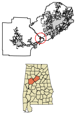
Jefferson County and Tuscaloosa County Alabama Incorporated and Unincorporated areas Lake View Highlighted 0140928.svg
Location of Lake View in Jefferson County and Tuscaloosa County, Alabama.
Coordinates: 33°16′48″N87°8′19″W / 33.28000°N 87.13861°W / 33.28000; -87.13861
Country United States
State Alabama
County Tuscaloosa (most)
Jefferson (portion)
Area
[2]
  Total2.34 sq mi (6.05 km2)
  Land2.10 sq mi (5.44 km2)
  Water0.23 sq mi (0.61 km2)
Population
 (2020)
  Total3,560
  Density1,693.63/sq mi (653.84/km2)
Time zone UTC-6 (Central (CST))
  Summer (DST) UTC-5 (CDT)
FIPS code 01-40928
Website lakeviewalabama.gov

Lake View is a city in Alabama, United States, with the majority in Tuscaloosa County and with a small portion in Jefferson County. [3] At the 2010 census the population was 1,943, up from 1,357 in 2000. It is part of the Tuscaloosa Metropolitan Statistical Area (the Tuscaloosa County portion) and the Birmingham metropolitan area (the Jefferson County portion). It is located approximately halfway between Tuscaloosa and Birmingham via Interstates 20 and 59.

Contents

History

Lake View was incorporated in 1998. [4]

Geography

Lake View is located at 33°16′48″N87°8′19″W / 33.28000°N 87.13861°W / 33.28000; -87.13861 (33.279933, -87.138667). [5]

According to the U.S. Census Bureau, the town has a total area of 1.8 square miles (4.7 km2), of which 1.6 square miles (4.1 km2) is land and 0.2 square miles (0.52 km2) (12.57%) is water.

Demographics

Historical population
CensusPop.Note
2000 1,357
2010 1,94343.2%
2020 3,56083.2%
U.S. Decennial Census [6]
2013 Estimate [7]

At the 2000 census there were 1,357 people, 457 households, and 405 families in the town. The population density was 847.7 inhabitants per square mile (327.3/km2). There were 475 housing units at an average density of 296.7 per square mile (114.6/km2). The racial makeup of the town was 97.35% White, 0.81% Black or African American, 0.07% Native American, 0.22% Asian, and 1.55% from two or more races. 0.22% of the population were Hispanic or Latino of any race. [8] Of the 457 households 44.4% had children under the age of 18 living with them, 82.3% were married couples living together, 3.7% had a female householder with no husband present, and 11.2% were non-families. 10.1% of households were one person and 3.7% were one person aged 65 or older. The average household size was 2.97 and the average family size was 3.17.

The age distribution was 28.8% under the age of 18, 6.6% from 18 to 24, 36.6% from 25 to 44, 20.6% from 45 to 64, and 7.4% 65 or older. The median age was 34 years. For every 100 females, there were 100.7 males. For every 100 females age 18 and over, there were 100.0 males.

The median household income was $54,879 and the median family income was $60,119. Males had a median income of $37,583 versus $29,688 for females. The per capita income for the town was $22,096. About 2.8% of families and 5.1% of the population were below the poverty line, including 6.8% of those under age 18 and 4.2% of those age 65 or over.

2010 census

At the 2010 census there were 1,943 people, 676 households, and 564 families in the town. The population density was 1,214.4 inhabitants per square mile (468.9/km2). There were 700 housing units at an average density of 437.5 per square mile (168.9/km2). The racial makeup of the town was 93.9% White, 4.2% Black or African American, 0.1% Native American, 0.7% Asian, and .9% from two or more races. 0.6% of the population were Hispanic or Latino of any race. [9] Of the 676 households 39.3% had children under the age of 18 living with them, 73.2% were married couples living together, 6.4% had a female householder with no husband present, and 16.6% were non-families. 13.2% of households were one person and 3.9% were one person aged 65 or older. The average household size was 2.87 and the average family size was 3.16.

The age distribution was 26.4% under the age of 18, 7.1% from 18 to 24, 30.8% from 25 to 44, 27.5% from 45 to 64, and 8.3% 65 or older. The median age was 35.9 years. For every 100 females, there were 96.9 males. For every 100 females age 18 and over, there were 97.8 males.

The median household income was $77,750 and the median family income was $81,250. Males had a median income of $53,646 versus $37,109 for females. The per capita income for the town was $28,334. About 0% of families and 2.4% of the population were below the poverty line, including 0% of those under age 18 and 0% of those age 65 or over.

Education

The portion in Tuscaloosa County is in the Tuscaloosa County School District. [10]

The portion in Jefferson County is in the Jefferson County School District. [11]

See also

Related Research Articles

<span class="mw-page-title-main">Walker County, Alabama</span> County in Alabama, United States

Walker County is a county located in the central portion of the U.S. state of Alabama. As of the 2020 census, the population was 65,342. Its county seat is Jasper. Its name is in honor of John Williams Walker, the first U.S. senator elected from Alabama.

<span class="mw-page-title-main">Vance, Alabama</span> Town in Alabama, United States

Vance is a town in Tuscaloosa and Bibb counties in the U.S. state of Alabama. As of the 2010 census it had a population of 1,529. It is most famous for the Mercedes-Benz U.S. International plant, currently the only one in North America. The current mayor of Vance is Brenda Morrison.

<span class="mw-page-title-main">County Line, Alabama</span> Town in Alabama, United States

County Line is a town in Blount and Jefferson counties in the State of Alabama. At the 2020 census, the population was 311.

<span class="mw-page-title-main">Arab, Alabama</span> City in Alabama, United States

Arab is a city in Marshall County in the northern part of the U.S. state of Alabama, located 10 miles (16 km) from Guntersville Lake and Guntersville Dam, and is included in the Huntsville-Decatur Combined Statistical Area. The population was 8,461 at the 2020 census.

<span class="mw-page-title-main">Moundville, Alabama</span> Town in Alabama, United States

Moundville is a town in Hale and Tuscaloosa counties in the U.S. state of Alabama. It was incorporated on December 22, 1908. From its incorporation until the 1970 census, it was wholly within Hale County. At the 2010 census the population was 2,427, up from 1,809 at the 2000 census. It is part of the Tuscaloosa Metropolitan Statistical Area. Within the town is Moundville Archaeological Site, the location of a prehistoric Mississippian culture political and ceremonial center.

<span class="mw-page-title-main">Adamsville, Alabama</span> City in Alabama, United States

Adamsville is a city in western Jefferson County, Alabama. It is north from the Birmingham suburb of Pleasant Grove. It initially incorporated in 1901, but disincorporated in 1915. It later reincorporated in 1953. According to the 2010 census, this town had a population of 4,522, down from its peak population of 4,965 in 2000.

<span class="mw-page-title-main">Graysville, Alabama</span> City in Alabama, United States

Graysville is a city in northwestern Jefferson County, Alabama, United States, located north of Adamsville. At the 2020 census, the population was 1,950.

<span class="mw-page-title-main">Morris, Alabama</span> Town in Alabama, United States

Morris is a town in Jefferson County, Alabama, United States. It is north of the Birmingham suburb of Gardendale. It initially incorporated on September 19, 1885. At some point after 1910, its incorporation lapsed and it failed to appear on the census rolls beginning in 1920 through to 1950. It reincorporated on July 11, 1950. The population as of the 2020 U.S. Census was 2,259, up from 1,859 in 2010.

<span class="mw-page-title-main">Trafford, Alabama</span> Town in Alabama, United States

Trafford is a town in Jefferson County, Alabama, United States. A small portion extends into Blount County. The town was incorporated in 1948. At the 2020 census, the population was 613.

<span class="mw-page-title-main">West Jefferson, Alabama</span> Town in Alabama, United States

West Jefferson is a town in Jefferson County, Alabama, United States. It incorporated in October 1964. At the 2010 census the population was 338, down from 344 in 2000.

<span class="mw-page-title-main">Millport, Alabama</span> Town in Alabama, United States

Millport is a town in Lamar County, Alabama, United States. It incorporated in 1887. At the 2010 census the population was 1,049, down from 1,160 in 2000. After its incorporation from 1890 to 1900, it was the largest town in Lamar County, losing the distinction to Sulligent. Since 1940, it has been the 3rd largest town.

<span class="mw-page-title-main">New Hope, Alabama</span> City in Alabama, United States

New Hope is a city in Madison County, Alabama, United States, and is included in the Huntsville-Decatur Combined Statistical Area. The population was 2,889 at the 2020 census.

<span class="mw-page-title-main">Linden, Alabama</span> City in Alabama, United States

Linden is a city in and the county seat of Marengo County, Alabama, United States. The population was 1,930 at the 2020 census, down from 2,123 at the 2010 census.

<span class="mw-page-title-main">Trinity, Alabama</span> Town in Alabama, United States

Trinity is a town in Morgan County, Alabama, United States. It is included in the Decatur Metropolitan Area and the Huntsville-Decatur Combined Statistical Area. As of the 2020 census, the population of the town was 2,526, up from 2,095 in 2010. It was incorporated in 1901.

<span class="mw-page-title-main">Wilsonville, Alabama</span> Town in Alabama, United States

Wilsonville is a town in southeastern Shelby County, Alabama, United States, located northeast of Columbiana. At the 2020 census, the population was 1,857. Wilsonville is named after the earliest settler in the area, Elisha Wilson.

<span class="mw-page-title-main">Brookwood, Alabama</span> City in Alabama, United States

Brookwood is a city in Tuscaloosa County, Alabama, United States. It incorporated in September 1977. As of the 2020 census, the population of the town is 2,504.

<span class="mw-page-title-main">Coker, Alabama</span> Town in Alabama, United States

Coker is a town in Tuscaloosa County, Alabama, United States. It incorporated in 1999. At the 2020 census, the population was 904. It is part of the Tuscaloosa, Alabama Metropolitan Statistical Area.

<span class="mw-page-title-main">Holt, Alabama</span> Census-designated place & Unincorporated community in Alabama, United States

Holt is an unincorporated community and census-designated place (CDP) in Tuscaloosa County, Alabama, United States. At the 2020 census, the population was 3,413. It is part of the Tuscaloosa, Alabama Metropolitan Statistical Area. Holt appeared on the 1930 census.

<span class="mw-page-title-main">Natural Bridge, Alabama</span> Town in Alabama, United States

Natural Bridge is a town at the southwest edge of Winston County, Alabama, United States, located near the intersection of U.S. Route 278, Alabama Highway 13, and Alabama State Route 5. It initially incorporated on September 3, 1914. In the 1930s, due to a dwindling population, its charter became dormant. On July 24, 1997, it reincorporated.

<span class="mw-page-title-main">Woodstock, Alabama</span> Town in Alabama, United States

Woodstock is a town in Bibb and Tuscaloosa counties in the U.S. state of Alabama. Formerly known as North Bibb, by referendum in August 2000, the town adopted the name of a long-established local unincorporated community and, as of October 1, 2000, is now known officially as "Woodstock". As of the 2010 census, the population of the town was 1,428.

References

  1. Code of Alabama 1975, Title 11, Chapter 40, Section 11-40-1 Archived March 17, 2010, at the Wayback Machine
  2. "2020 U.S. Gazetteer Files". United States Census Bureau. Retrieved October 29, 2021.
  3. "2020 CENSUS - CENSUS BLOCK MAP: Lake View town, AL" (PDF). U.S. Census Bureau . Retrieved March 29, 2024.
  4. "What's in a name". The Tuscaloosa News. April 20, 2000. pp. 4B. Retrieved May 30, 2015.
  5. "US Gazetteer files: 2010, 2000, and 1990". United States Census Bureau. February 12, 2011. Retrieved April 23, 2011.
  6. "U.S. Decennial Census". Census.gov. Retrieved June 6, 2013.
  7. "Annual Estimates of the Resident Population: April 1, 2010 to July 1, 2013". Archived from the original on May 22, 2014. Retrieved June 3, 2014.
  8. "U.S. Census website". United States Census Bureau . Retrieved January 31, 2008.
  9. "U.S. Census website". United States Census Bureau . Retrieved August 13, 2015.
  10. "2020 CENSUS - SCHOOL DISTRICT REFERENCE MAP: Tuscaloosa County, AL" (PDF). U.S. Census Bureau. pp. 37-38 (PDF p. 38-39/41). Retrieved March 29, 2024. - Text list
  11. "2020 CENSUS - SCHOOL DISTRICT REFERENCE MAP: Jefferson County, AL" (PDF). U.S. Census Bureau. p. 22 (PDF p. 23/24). Retrieved March 29, 2024. - Text list

Commons-logo.svg Media related to Lake View, Alabama at Wikimedia Commons