Mulga, Alabama

Last updated

Mulga, Alabama
Flag of Mulga, Alabama.png
Seal of Mulga, Alabama.png
Jefferson County Alabama Incorporated and Unincorporated areas Mulga Highlighted 0152776.svg
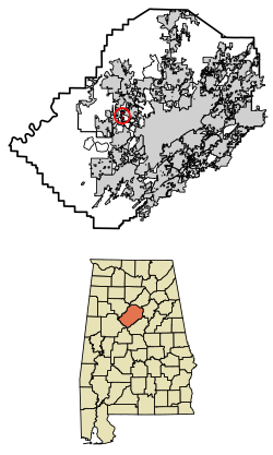
Location of Mulga in Jefferson County, Alabama.
Coordinates: 33°33′13″N86°58′31″W / 33.55361°N 86.97528°W / 33.55361; -86.97528
Country United States
State Alabama
County Jefferson
Area
[1]
  Total0.87 sq mi (2.26 km2)
  Land0.87 sq mi (2.24 km2)
  Water0.01 sq mi (0.01 km2)
Elevation
574 ft (175 m)
Population
 (2020)
  Total784
  Density905.31/sq mi (349.67/km2)
Time zone UTC-6 (Central (CST))
  Summer (DST) UTC-5 (CDT)
ZIP code
35118
Area code(s) 205 & 659
FIPS code 01-52776
GNIS feature ID0152567

Mulga is a town in western Jefferson County, Alabama, United States. It is north from the Birmingham suburb of Pleasant Grove. It includes the community of Bayview. Mulga was a company town operated by Birmingham Coal and Iron Company around the Mulga Mine and Mulga was also the name of an independent community in the area. The company town was incorporated in 1947. [2]

Contents

At its 2010 census the population was 836, down from its peak population of 973 in 2000. Its communities were damaged by an F5 tornado on April 8, 1998. The town's name is possibly derived from the Creek word omalga meaning "all".

Coal has been mined in the area. Forty-one men died in a 1910 coal mine explosion. [3] Steel industry was also active in the area and served by a dam. Rail service was established.

Geography

Mulga is located at 33°32′56″N86°58′38″W / 33.54889°N 86.97722°W / 33.54889; -86.97722 (33.548891, -86.977254). [4]

According to the U.S. Census Bureau, the town has a total area of 0.6 square miles (1.6 km2), all land.

Demographics

Historical population
CensusPop.Note
1950 532
1960 482−9.4%
1970 58220.7%
1980 405−30.4%
1990 261−35.6%
2000 973272.8%
2010 836−14.1%
2020 784−6.2%
U.S. Decennial Census [5]
2013 Estimate [6]

2020 census

Mulga racial composition [7]
RaceNum.Perc.
White (non-Hispanic)64582.27%
Black or African American (non-Hispanic)10413.27%
Native American 30.38%
Asian 10.13%
Other/Mixed 253.19%
Hispanic or Latino 60.77%

As of the 2020 United States census, there were 784 people, 359 households, and 237 families residing in the town.

2000 census

As of the census [8] of 2000, there were 973 people, 390 households, and 276 families residing in the town. The population density was 1,604.2 inhabitants per square mile (619.4/km2). There were 425 housing units at an average density of 700.7 per square mile (270.5/km2). The racial makeup of the town was 85.10% White, 13.16% Black or African American, 0.62% Native American, 0.31% Asian, and 0.82% from two or more races. 0.10% of the population were Hispanic or Latino of any race.

There were 390 households, out of which 32.8% had children under the age of 18 living with them, 51.0% were married couples living together, 16.4% had a female householder with no husband present, and 29.2% were non-families. 27.2% of all households were made up of individuals, and 17.2% had someone living alone who was 65 years of age or older. The average household size was 2.49 and the average family size was 3.04.

In the town, the population was spread out, with 24.4% under the age of 18, 9.4% from 18 to 24, 28.1% from 25 to 44, 21.4% from 45 to 64, and 16.9% who were 65 years of age or older. The median age was 37 years. For every 100 females, there were 85.7 males. For every 100 females age 18 and over, there were 79.1 males.

The median income for a household in the town was $36,500, and the median income for a family was $41,382. Males had a median income of $31,438 versus $23,750 for females. The per capita income for the town was $16,622. About 8.6% of families and 10.8% of the population were below the poverty line, including 13.5% of those under age 18 and 14.0% of those age 65 or over.

Related Research Articles

<span class="mw-page-title-main">Altoona, Alabama</span> Town in Alabama, United States

Altoona is a town in Etowah County in the U.S. state of Alabama. It is part of the Gadsden Metropolitan Statistical Area. At the 2020 census, the population was 948.

<span class="mw-page-title-main">Locust Fork, Alabama</span> Town in the United States

Locust Fork is a town in Blount County, Alabama, United States. At the 2010 census the population was 1,186 people, up from 1,016 in 2000.

<span class="mw-page-title-main">Colony, Alabama</span> Town in Alabama, United States

Colony is a town in Cullman County, Alabama, United States. At the 2010 census the population was 268, down from 385 in 2000. Colony is a historically African-American town. In its early days it was a haven for African Americans in the Deep South. It incorporated in 1981.

<span class="mw-page-title-main">Brighton, Alabama</span> City in Alabama, United States

Brighton is a city near Birmingham, Alabama, United States and located just east of Hueytown. At the 2020 census, the population was 2,337. It is part of the Birmingham-Hoover Metropolitan Statistical Area, which in 2010 had a population of about 1,128,047, approximately one-quarter of Alabama's population.

<span class="mw-page-title-main">Brookside, Alabama</span> Town in Alabama, United States

Brookside is a town in north-central Jefferson County, Alabama, United States. As of the 2020 census, the population of the town was 1,253. It is a former mining town.

<span class="mw-page-title-main">Cardiff, Alabama</span> Town in Alabama, United States

Cardiff is a town in Jefferson County, Alabama, United States west of Gardendale. At the 2010 census the population was 55, placing it as the least-populated incorporated area in Jefferson County. It is named after the capital of Wales. It is one of four Jefferson County cities named after cities in Great Britain, the others being Birmingham, Leeds and Brighton.

<span class="mw-page-title-main">Edgewater, Alabama</span> CDP in Alabama, United States

Edgewater is a census-designated place in Jefferson County, Alabama, United States. It is northeast from the Birmingham suburb of Pleasant Grove. Its population was 883 at the 2010 census. This area was damaged by tornadoes on April 15, 1956 and April 8, 1998. The 1998 tornado was rated F5 on the Fujita scale.

<span class="mw-page-title-main">Graysville, Alabama</span> City in Alabama, United States

Graysville is a city in northwestern Jefferson County, Alabama, United States, located north of Adamsville. At the 2020 census, the population was 1,950.

<span class="mw-page-title-main">Homewood, Alabama</span> City in Alabama, United States

Homewood is a city in southeastern Jefferson County, Alabama, United States. It is a suburb of Birmingham, located on the other side of Red Mountain due south of the city center. The population was 26,414 at the 2020 census.

<span class="mw-page-title-main">Kimberly, Alabama</span> City in Alabama, United States

Kimberly is a city in Jefferson County, Alabama, United States. At the 2020 census, the population was 3,841.

<span class="mw-page-title-main">Midfield, Alabama</span> Town in Alabama, United States

Midfield is a town in Jefferson County, Alabama, United States, located two miles south of the Birmingham suburb of Fairfield. It incorporated in 1953. As of the 2020 census, it had a population of 5,211.

<span class="mw-page-title-main">Minor, Alabama</span> CDP in Alabama, United States

Minor is a census-designated place (CDP) in Jefferson County, Alabama, United States. It is located north of the Birmingham suburb, Pleasant Grove and has a population of 1,094. Minor was damaged by an F5 tornado on April 8, 1998, including damage inflicted on the non-denominational Open Door Church.

<span class="mw-page-title-main">Pleasant Grove, Alabama</span> City in Alabama, United States

Pleasant Grove is a city in western Jefferson County, Alabama, United States. It is part of the Birmingham metropolitan area. The population was 9,544 at the 2020 census.

<span class="mw-page-title-main">Trafford, Alabama</span> Town in Alabama, United States

Trafford is a town in Jefferson County, Alabama, United States. A small portion extends into Blount County. The town was incorporated in 1948. At the 2020 census, the population was 613.

<span class="mw-page-title-main">Montevallo, Alabama</span> City in Alabama, United States

Montevallo is a city in Shelby County, Alabama, United States. A college town, it is the home of the University of Montevallo, a public liberal arts university with approximately 3,000 students. As of the 2020 census, the population of the city of Montevallo is 7,229.

<span class="mw-page-title-main">Wilton, Alabama</span> Town in Alabama, United States

Wilton, also known by the previous names of Birmingham Junction, Bismark, and Catoosa, is a town in Shelby County, Alabama, United States. It was incorporated in 1918. This town is part of the Birmingham–Hoover–Cullman Combined Statistical Area. At the 2010 census the population was 687, up from 580 in 2000.

<span class="mw-page-title-main">Ragland, Alabama</span> Town in Alabama, United States

Ragland is a town in St. Clair County, Alabama, United States southeast of Ashville. It incorporated in 1899. At the 2020 census, the population was 1,693, up slightly from 1,639 in 2010. It is part of the Birmingham-Hoover-Cullman Combined Statistical Area.

<span class="mw-page-title-main">Dora, Alabama</span> City in Alabama, United States

Dora is a city in Walker County, Alabama, United States. Coal mining took place in the area.

<span class="mw-page-title-main">Jasper, Alabama</span> City in Alabama, United States

Jasper is a city in and the county seat of Walker County, Alabama, United States. Its population was 14,352 as of the 2010 census. Named in honor of Sergeant William Jasper, an American Revolutionary War hero, Jasper was settled around 1815 and incorporated on August 18, 1886.

<span class="mw-page-title-main">Thurmond, West Virginia</span> Town in West Virginia, United States

Thurmond is a town in Fayette County, West Virginia, United States, on the New River. The population was five at the 2020 census. During the heyday of coal mining in the New River Gorge, Thurmond was a prosperous town with a number of businesses and facilities for the Chesapeake and Ohio Railway.

References

  1. "2020 U.S. Gazetteer Files". United States Census Bureau. Retrieved October 29, 2021.
  2. "Mulga - Encyclopedia of Alabama". Encyclopedia of Alabama.
  3. "The Engineering and Mining Journal 1910-05-07: Vol 89 Iss 19" (PDF).
  4. "US Gazetteer files: 2010, 2000, and 1990". United States Census Bureau. February 12, 2011. Retrieved April 23, 2011.
  5. "U.S. Decennial Census". Census.gov. Retrieved June 6, 2013.
  6. "Annual Estimates of the Resident Population: April 1, 2010 to July 1, 2013". Census.gov . Retrieved June 3, 2014.
  7. "Explore Census Data". data.census.gov. Retrieved December 11, 2021.
  8. "U.S. Census website". United States Census Bureau . Retrieved January 31, 2008.