
The Last Glacial Period (LGP), also known colloquially as the last ice age or simply ice age, occurred from the end of the Eemian to the end of the Younger Dryas, encompassing the period c. 115,000 – c. 11,700 years ago. The LGP is part of a larger sequence of glacial and interglacial periods known as the Quaternary glaciation which started around 2,588,000 years ago and is ongoing. The definition of the Quaternary as beginning 2.58 million years ago (Mya) is based on the formation of the Arctic ice cap. The Antarctic ice sheet began to form earlier, at about 34 Mya, in the mid-Cenozoic. The term Late Cenozoic Ice Age is used to include this early phase. The previous ice age, the Saalian glaciation, which ended about 128,000 years ago, was more severe than the Last Glacial Period in some areas such as Britain, but less severe in others.

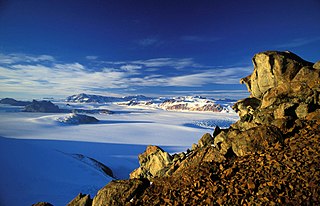
The McMurdo Dry Valleys are a row of largely snow-free valleys in Antarctica, located within Victoria Land west of McMurdo Sound. The Dry Valleys experience extremely low humidity and surrounding mountains prevent the flow of ice from nearby glaciers. The rocks here are granites and gneisses, and glacial tills dot this bedrock landscape, with loose gravel covering the ground. It is one of the driest places on Earth and has not seen rain for nearly two million years.

Lake Vida is a hypersaline lake in Victoria Valley, the northernmost of the large McMurdo Dry Valleys, on the continent of Antarctica. It is isolated under year-round ice cover, and is considerably more saline than seawater. It came to public attention in 2002 when microbes frozen in its ice cover for more than 2,800 years were successfully thawed and reanimated.
The Transantarctic Mountains comprise a mountain range of uplifted rock in Antarctica which extend, with some interruptions, across the continent from Cape Adare in northern Victoria Land to Coats Land. These mountains divide East Antarctica and West Antarctica. They include a number of separately named mountain groups, which are often again subdivided into smaller ranges.

Canada Glacier is a small glacier flowing south-east into the northern side of Taylor Valley in Victoria Land, Antarctica. It is in the Ross Dependency. Its melting season is in the summer.
Lake Fryxell is a frozen lake 4.5 kilometres (2.8 mi) long, between Canada Glacier and Commonwealth Glaciers at the lower end of Taylor Valley in Victoria Land, Antarctica. It was mapped in the early 1900s and named during Operation Deep Freeze in the 1950s. There are several forms of algae living in the waters and a weather station located at the lake.

Mount Morning is a shield volcano at the foot of the Transantarctic Mountains in Victoria Land, Antarctica. It lies 100 kilometres (62 mi) from Ross Island. Mount Morning rises to an elevation of 2,723 metres (8,934 ft) and is almost entirely mantled with snow and ice. A 4.1 by 4.9 kilometres wide summit caldera lies at the top of the volcano and several ice-free ridges such as Hurricane Ridge and Riviera Ridge emanate from the summit. A number of parasitic vents mainly in the form of cinder cones dot the mountain.

Mount Takahe is a 3,460-metre-high (11,350 ft) snow-covered shield volcano in Marie Byrd Land, Antarctica, 200 kilometres (120 mi) from the Amundsen Sea. It is a c. 30-kilometre-wide (19 mi) mountain with parasitic vents and a caldera up to 8 kilometres (5 mi) wide. Most of the volcano is formed by trachytic lava flows, but hyaloclastite is also found. Snow, ice, and glaciers cover most of Mount Takahe. With a volume of 780 km3 (200 cu mi), it is a massive volcano; the parts of the edifice that are buried underneath the West Antarctic Ice Sheet are probably even larger. It is part of the West Antarctic Rift System along with eighteen other known volcanoes.
The Pleiades are a volcanic group in northern Victoria Land of Antarctica. It consists of youthful cones and domes with Mount Atlas/Mount Pleiones, a small stratovolcano formed by three overlapping cones, being the dominant volcano and rising 500 m (1,600 ft) above the Evans Névé plateau. Two other named cones are Alcyone Cone and Taygete Cone, the latter of which has been radiometrically dated to have erupted during the Holocene. A number of tephra layers across Antarctica have been attributed to eruptions of this volcanic group, including several that may have occurred within the last few hundred years.
A subglacial lake is a lake that is found under a glacier, typically beneath an ice cap or ice sheet. Subglacial lakes form at the boundary between ice and the underlying bedrock, where gravitational pressure decreases the pressure melting point of ice. Over time, the overlying ice gradually melts at a rate of a few millimeters per year. Meltwater flows from regions of high to low hydraulic pressure under the ice and pools, creating a body of liquid water that can be isolated from the external environment for millions of years.
The Holocene glacial retreat is a geographical phenomenon that involved the global retreat of glaciers (deglaciation) that previously had advanced during the Last Glacial Maximum. Ice sheet retreat initiated ca. 19,000 years ago and accelerated after ca. 15,000 years ago. The Holocene, starting with abrupt warming 11,700 years ago, resulted in rapid melting of the remaining ice sheets of North America and Europe.

Lake Hoare is a lake about 4.2 kilometres (2.6 mi) long between Lake Chad and Canada Glacier in Taylor Valley, Victoria Land, Antarctica. Its surface area measures 1.94 square kilometres (0.75 sq mi). The lake was named by the 8th Victoria University of Wellington Antarctic Expedition (VUWAE), 1963–64, for physicist Ray A. Hoare, a member of the VUWAE that examined lakes in Taylor, Wright, and Victoria Valleys.

Lake Bonney is a saline lake with permanent ice cover at the western end of Taylor Valley in the McMurdo Dry Valleys of Victoria Land, Antarctica.
Sollipulli is an ice-filled volcanic caldera and volcanic complex, which lies southeast of the small town of Melipeuco in the La Araucanía Region, Chile. It is part of the Southern Volcanic Zone of the Andes, one of the four volcanic belts in the Andes chain.
Taylor Valley is the southernmost of the three large McMurdo Dry Valleys in the Transantarctic Mountains, Victoria Land, Antarctica, located west of McMurdo Sound at approximately 77°37′S163°00′E. The valley extends from Taylor Glacier in the west to McMurdo Sound at Explorers Cove at the northwest head of New Harbour in the east and is about 29 kilometres (18 mi) long. It was once occupied by the receding Taylor Glacier, from which it derives its name. Taylor Valley contains Lake Bonney in the west (inward), and Lake Fryxell in the east (coastward), and Lake Hoare, Lake Chad, Lake Popplewell, Mummy Pond and Parera Pond close together between the two. Further east of Lake Bonney is Pearse Valley. Taylor Valley is separated from Wright Valley in the north by Asgard Range, and from Ferrar Glacier in the south by Kukri Hills.

Blood Falls is an outflow of an iron oxide-tainted plume of saltwater, flowing from the tongue of Taylor Glacier onto the ice-covered surface of West Lake Bonney in the Taylor Valley of the McMurdo Dry Valleys in Victoria Land, East Antarctica.
Deglaciation is the transition from full glacial conditions during ice ages, to warm interglacials, characterized by global warming and sea level rise due to change in continental ice volume. Thus, it refers to the retreat of a glacier, an ice sheet or frozen surface layer, and the resulting exposure of the Earth's surface. The decline of the cryosphere due to ablation can occur on any scale from global to localized to a particular glacier. After the Last Glacial Maximum, the last deglaciation begun, which lasted until the early Holocene. Around much of Earth, deglaciation during the last 100 years has been accelerating as a result of climate change, partly brought on by anthropogenic changes to greenhouse gases.

Bjørn Grothaug Andersen was a Norwegian professor of Quaternary geology and glaciology who made foundational contributions to glacial geology and the understanding of climate change.

Lake Tauca is a former lake in the Altiplano of Bolivia. It is also known as Lake Pocoyu for its constituent lakes: Lake Poopó, Salar de Coipasa and Salar de Uyuni. The lake covered large parts of the southern Altiplano between the Eastern Cordillera and the Western Cordillera, covering an estimated 48,000 to 80,000 square kilometres of the basins of present-day Lake Poopó and the Salars of Uyuni, Coipasa and adjacent basins. Water levels varied, possibly reaching 3,800 metres (12,500 ft) in altitude. The lake was saline. The lake received water from Lake Titicaca, but whether this contributed most of Tauca's water or only a small amount is controversial; the quantity was sufficient to influence the local climate and depress the underlying terrain with its weight. Diatoms, plants and animals developed in the lake, sometimes forming reef knolls.

The last glacial period and its associated glaciation is known in southern Chile as the Llanquihue glaciation. Its type area lies west of Llanquihue Lake where various drifts or end moraine systems belonging to the last glacial period have been identified. The glaciation is the last episode of existence of the Patagonian Ice Sheet.
