Langeoog

Last updated
Langeoog
Flug Langeoog 2010 PD 075.JPG
Aerial view of Langeoog from the north
Flagge Langeoog.svg
Wappen Langeoog.svg
Location of Langeoog within Wittmund district
Langeoog in WTM.svgEsensBlombergDunum
Germany adm location map.svg
Red pog.svg
Langeoog
Lower Saxony location map.svg
Red pog.svg
Langeoog
Coordinates: 53°44′54″N7°28′47″E / 53.74833°N 7.47972°E / 53.74833; 7.47972
Country Germany
State Lower Saxony
District Wittmund
Government
   Mayor (201924) Heike Horn [1] (Ind.)
Area
  Total19.67 km2 (7.59 sq mi)
Elevation
5 m (16 ft)
Population
 (2021-12-31) [2]
  Total1,792
  Density91/km2 (240/sq mi)
Time zone UTC+01:00 (CET)
  Summer (DST) UTC+02:00 (CEST)
Postal codes
26465
Dialling codes 04972
Vehicle registration WTM
Website www.langeoog.de

Langeoog (Low German : Langeoog) is one of the seven inhabited East Frisian Islands at the edge of the Lower Saxon Wadden Sea in the southern North Sea, located between Baltrum Island (west), and Spiekeroog (east). It is also a municipality in the district of Wittmund in Lower Saxony, Germany. The name Langeoog means Long Island in the Low German dialect.

Contents

Geography

Langeoog's beach is 14 km (9 mi) long. Langeoog's actual size depends on the level of tide, which rises and falls about 2.5 metres (8 ft 2.4 in) in 6 hours.

Geology

Langeoog is geologically nothing but sand. Rainwater that falls into the sand has a lower density than saltwater, which makes a kind of freshwater bubble float over the saltwater surrounding and deep under the island.

The beach and the dunes are eroded by the sea in the western part of the island. Since about 1970, Langeoog's western end has moved several hundred metres to the east. This happens on every East Frisian island some islands moved so far that the town had to be rebuilt several times. Every island except Juist and Langeoog has large concrete groynes at its western end to reduce erosion.

History

Storm tides

In 1717 Langeoog was cut in three parts by the Christmas storm tide.

Nazi era

During the Nazi era, the government expanded Langeoog as an air base starting in 1940. On August 22, 1940, 250 French prisoners of war were transferred to the island to perform forced labor. Starting in 1941, 113 Soviet prisoners of war were also brought to the island. They died due to inhumane treatment; a memorial at the Langeoog Dunes Cemetery today commemorates their fate. There were also summer camps for the Hitler Youth on the island as early as the 1930s. [3] [4] During this same period, the expelled Jewish family of Heer were living there along with a group of Jewish children from Halberstadt who were in hiding and secretly cared for by the courageous Haus Bethanien sisters. [5]

Deaths

The Iranologist and linguist Christian Bartholomae died on the island in 1925. [6] [7] The meteorologist Johannes Letzmann lived on Langeoog from 1962 to his death in 1971.

Transportation

Ferry Langeoog IV in the morning LangeoogIV.jpg
Ferry Langeoog IV in the morning
Dune cemetery with a memorial for Russian prisoners of war Dunenfriedhof Langeoog (Luftaufnahme).jpg
Dune cemetery with a memorial for Russian prisoners of war

Langeoog can be reached from Bensersiel  [ de ] port on the East Frisian mainland by the ferries of the Langeoog Shipping Company: Langeoog I, Langeoog II, Langeoog III and Langeoog IV. Langeoog ferries' schedule does not depend on the tide, which is unusual among East Frisian ferries.

The port and the town are linked by a railway, and Langeoog also has an airport.

Langeoog largely has a no automobile policy. Visitors to the island have to leave their cars on the mainland. Only the fire department and ambulance service have standard motorized vehicles. Tractors and heavy construction vehicles can be operated within limits. The policemen and doctors get about on bicycles. Some companies (construction, drink delivery, post office, etc.) have electric cars. The post office and the shipping company have one electric car each. If one does not want to walk, one can rent a bicycle or take a horse carriage taxi.

Tourism

Tourism is the main source of income for Langeoog's economy. There are guest rooms in almost all island buildings. There are also several hotels. The youth hostel is several kilometers outside the town.

The island's unpolluted air makes it popular with people who have respiratory problems.

Landmarks

A Lili Marleen and Lale Andersen memorial in Langeoog Wasserturm Langeoog.jpg
A Lili Marleen and Lale Andersen memorial in Langeoog

Famous people

Singer-songwriter Lale Andersen, whose 1939 interpretation of the song Lili Marleen became tremendously popular during World War II, lived here for several years. Although she died in Vienna in 1972, she is buried on the island's dune cemetery. A bronze memorial in her honor has been erected on Langeoog.

See also

Related Research Articles

<span class="mw-page-title-main">Sylt</span> German island in the North Sea

Sylt is a former island in northern Germany, part of Nordfriesland district, Schleswig-Holstein, well known for the distinctive shape of its shoreline. It belongs to the North Frisian Islands and is the largest island in North Frisia. The northernmost island of Germany, it is known for its tourist resorts, notably Westerland, Kampen and Wenningstedt-Braderup, as well as for its 40-kilometre-long (25-mile) sandy beach. It is frequently covered by the media in connection with its exposed situation in the North Sea and its ongoing loss of land during storm tides. Since 1927, Sylt has been connected to the mainland by the Hindenburgdamm causeway. In later years, it has been a resort for the German jet set and tourists in search of occasional celebrity sightings.

<span class="mw-page-title-main">Ameland</span> Municipality and island of the Netherlands

Ameland is a municipality and one of the West Frisian Islands off the north coast of the Netherlands. It consists mostly of sand dunes and is the third major island of the West Frisians. It neighbours islands Terschelling to the west and Schiermonnikoog to the east. This includes the small Engelsmanplaat and Rif sandbanks to the east.

<span class="mw-page-title-main">East Frisian Islands</span> Chain of German islands in the North Sea

The East Frisian Islands are a chain of islands in the North Sea, off the coast of East Frisia in Lower Saxony, Germany. The islands extend for some 90 kilometres (56 mi) from west to east between the mouths of the Ems and Jade / Weser rivers and lie about 3.5 to 10 km offshore. Between the islands and the mainland are extensive mudflats, known locally as Watten, which form part of the Wadden Sea. In front of the islands are Germany's territorial waters, which occupy a much larger area than the islands themselves. The islands, the surrounding mudflats and the territorial waters form a close ecological relationship. The island group makes up about 5% of the Lower Saxony Wadden Sea National Park.

<span class="mw-page-title-main">Wittmund (district)</span> District in Lower Saxony, Germany

Wittmund is a Landkreis (district) in the northwestern part of Lower Saxony, Germany. It is situated in East Frisia, on the North Sea coast. Neighboring districts are Friesland, Leer and Aurich.

<span class="mw-page-title-main">East Frisia</span> Historic region in Lower Saxony, Germany

East Frisia or East Friesland is a historic region in the northwest of Lower Saxony, Germany. It is primarily located on the western half of the East Frisian peninsula, to the east of West Frisia and to the west of Landkreis Friesland.

<span class="mw-page-title-main">Borkum</span> Municipality in Lower Saxony, Germany

Borkum is an island and a municipality in the Leer District in Lower Saxony, northwestern Germany. It is situated east of Rottumeroog and west of Juist.

<span class="mw-page-title-main">Amrum</span> German island

Amrum is one of the North Frisian Islands on the German North Sea coast, south of Sylt and west of Föhr. It is part of the Nordfriesland district in the federal state of Schleswig-Holstein and has approximately 2,300 inhabitants.

<span class="mw-page-title-main">Frisian Islands</span> Archipelago in the Wadden Sea

The Frisian Islands, also known as the Wadden Islands or the Wadden Sea Islands, form an archipelago at the eastern edge of the North Sea in northwestern Europe, stretching from the northwest of the Netherlands through Germany to the west of Denmark. The islands shield the mudflat region of the Wadden Sea from the North Sea.

<span class="mw-page-title-main">Butjadingen</span> Municipality in Lower Saxony, Germany

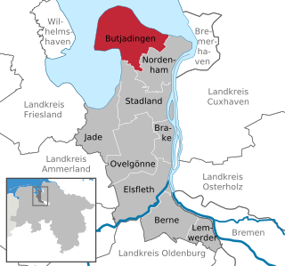
Butjadingen is a peninsula and municipality in the Wesermarsch district, in Lower Saxony, Germany.

<span class="mw-page-title-main">Wittmund</span> Town in Lower Saxony, Germany


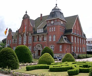
Wittmund is a town and capital of the district of Wittmund, in Lower Saxony, Germany.

<span class="mw-page-title-main">Norderney</span> Town in Lower Saxony, Germany

Norderney is one of the seven populated East Frisian Islands off the North Sea coast of Germany.

<span class="mw-page-title-main">Juist</span> Municipality in Lower Saxony, Germany

Juist is an island and municipality in the district of Aurich in Lower Saxony in Germany. The island is one of seven East Frisian Islands at the edge of the Lower Saxon Wadden Sea in the southern North Sea. It is located between Borkum Island (west), Memmert Island (southwest) and Norderney (east). The island is 17 km (11 mi) long and from 500 metres (1,600 ft) to 1 kilometre (0.62 mi) wide, depending on the tide levels. There are two villages on the island: the main village Juist, and Loog. The island is separated from Norderney by the Norderneyer Seegatt.

<span class="mw-page-title-main">Papenburg</span> Town in Lower Saxony, Germany

Papenburg is a city in the district of Emsland, Lower Saxony, Germany, situated at the river Ems. It is known for its large shipyard, the Meyer-Werft, which specializes in building cruise liners.

<span class="mw-page-title-main">Garbsen</span> Town in Lower Saxony, Germany

Garbsen is a town in the district of Hanover, in Lower Saxony, Germany. It is situated on the river Leine, approx. 11 km northwest of Hanover. The name Garbsen can be traced back to 1223. Today's 13 city districts have partly developed independently until the city of Garbsen was formed within its current boundaries during the regional reform in 1974.

<span class="mw-page-title-main">Wangerooge</span> Municipality in Lower Saxony, Germany

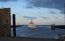
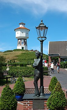
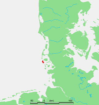
Wangerooge is one of the 32 Frisian Islands in the North Sea located close to the coasts of the Netherlands, Germany and Denmark. It is also a municipality in the district of Friesland in Lower Saxony in Germany.

<span class="mw-page-title-main">Baltrum</span> Municipality in Lower Saxony, Germany

Baltrum is a barrier island off the coast of East Frisia, in Germany, and is a municipality in the district of Aurich, Lower Saxony. It is located in-between the chain of the seven inhabited East Frisian Islands. Baltrum is the smallest island in this chain by area and inhabitants. It has a land area of 6.5 square kilometres, and a population in (2011) of just over 500 resident inhabitants.

<span class="mw-page-title-main">Spiekeroog</span> Municipality in Lower Saxony, Germany

Spiekeroog is one of the East Frisian Islands, off the North Sea coast of Germany. It is situated between Langeoog to its west, and Wangerooge to its east. The island belongs to the district of Wittmund, in Lower Saxony in Germany. The only village on the island is also called Spiekeroog. The island is part of the Wadden Sea World Heritage Site by the UNESCO and the Lower Saxon Wadden Sea National Park.

<span class="mw-page-title-main">Wangerooge Island Railway</span>

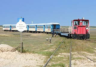
The single track Wangerooge Island Railway is an unelectrified narrow gauge railway with a track gauge of 1,000 mm located on the East Frisian island of Wangerooge off the northwestern coast of Germany. It is the most important means of transport on the island and is the only narrow gauge railway operated today by the Deutsche Bahn.

<span class="mw-page-title-main">Minsener Oog</span> East Frisian island

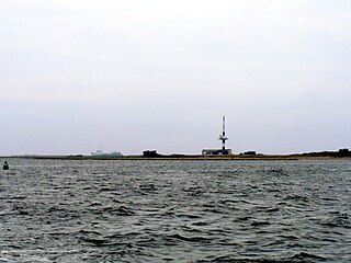
Minsener Oog, also Minser Oog or Minsener Oldeoog, is an uninhabited East Frisian island that belongs to the parish of Wangerooge in the north German district of Friesland in the state of Lower Saxony. It has been artificially enlarged through the construction of groynes.

References

  1. "Verzeichnis der direkt gewählten Bürgermeister/-innen und Landräte/Landrätinnen". Landesamt für Statistik Niedersachsen. April 2021.
  2. "LSN-Online Regionaldatenbank, Tabelle A100001G: Fortschreibung des Bevölkerungsstandes, Stand 31. Dezember 2021" (in German). Landesamt für Statistik Niedersachsen.
  3. NS-Zeit auf Langeoog, Larissa Siebolds: "Auf Langeoog sollen nun Stolpersteine an die jüdische Familie de Heer erinnern – Verlegung 2024", NWZ-online, 14 april 2023, accessed, 9 September 2023.
  4. Zeltlager anno 1936: Der Jugendkult der Nazis, Ostfriesland Reloaded, 5 August 2022, accessed 9 September 2023.
  5. Inselkirche Langeoog – Chronik auf www.inselkark.de
  6. Schmitt, Rüdiger (15 December 1988). "BARTHOLOMAE, CHRISTIAN". Encyclopædia Iranica . Retrieved 15 December 2023.
  7. "Bartholomae, Christian". Hrvatska enciklopedija, mrežno izdanje (in Croatian). Leksikografski zavod Miroslav Krleža. 2021. Retrieved 15 December 2023.