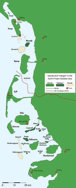
The North Frisian Islands are the Frisian Islands off the coast of North Frisia.

The Wadden Sea National Parks in Denmark, Germany and the Netherlands are located along the German Bight of the North Sea. In Germany and Denmark they also mark the area of the UNESCO World Heritage Site of the Wadden Sea. Divided from each other by administrative borders, they form a single ecological entity. The purpose of the national parks is the protection of the Wadden Sea ecoregion.
The Schleswig-Holstein Wadden Sea National Park is a national park in the Schleswig-Holstein area of the German Wadden Sea. It was founded by the Parliament of Schleswig-Holstein on 1 October 1985 by the National Park Act of 22 July 1985 and expanded significantly in 1999. Together with the Lower Saxon Wadden Sea National Park, the Hamburg Wadden Sea National Park and those parts of Elbe estuary which are not nature reserves, it forms the German part of the Wadden Sea.
The Hamburg Wadden Sea National Park is the smallest of the three German Wadden Sea National Parks which protect the single ecological entity of the Wadden Sea reaching from Den Helder to Esbjerg.
Amrum is one of the North Frisian Islands on the German North Sea coast, south of Sylt and west of Föhr. It is part of the Nordfriesland district in the federal state of Schleswig-Holstein and has approximately 2,300 inhabitants.

The Frisian Islands, also known as the Wadden Islands or the Wadden Sea Islands, form an archipelago at the eastern edge of the North Sea in northwestern Europe, stretching from the northwest of the Netherlands through Germany to the west of Denmark. The islands shield the mudflat region of the Wadden Sea from the North Sea.

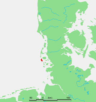
Dagebüll is a municipality located at the west coast of Schleswig-Holstein in the Nordfriesland district, Germany. Today's Dagebüll was created in 1978 as a merger of the municipalities of Fahretoft, Juliane-Marien-Koog and Waygaard. Dagebüll used to be a Hallig, the oldest houses were built on artificial dwelling hills which in parts can still be seen today. In 1704 the area was secured by sea dikes.
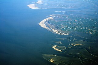
The German Bight is the southeastern bight of the North Sea bounded by the Netherlands and Germany to the south, and Denmark and Germany to the east. To the north and west it is limited by the Dogger Bank. The Bight contains the Frisian and Danish Islands. The Wadden Sea is approximately ten to twelve kilometres wide at the location of the German Bight. The Frisian islands and the nearby coastal areas are collectively known as Frisia. The southern portion of the bight is also known as the Heligoland Bight. Between 1949 and 1956 the BBC Sea Area Forecast used "Heligoland" as the designation for the area now referred to as German Bight.
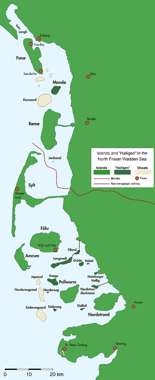
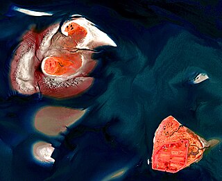
The Halligen or the halliger are small islands without protective dikes. They are variously pluralized in English as the Halligen, Halligs, Hallig islands, or Halligen islands. There are ten German halligen in the North Frisian Islands on Schleswig-Holstein's Wadden Sea–North Sea coast in the district of Nordfriesland and one hallig at the west coast of Denmark (Mandø).
Hooge is a municipality in the district of Nordfriesland, in Schleswig-Holstein, Germany.

Langeneß (help·info) is a municipality in the district of Nordfriesland, in Schleswig-Holstein, Germany. It consists of the halligen (islands) Langeneß and Oland. Before the flood of 1634 the two islands were directly attached.

Norderoog is one of the ten German halligen islands of the North Frisian Islands in the Wadden Sea, which is part of the North Sea off the coast of Germany. A part of Hooge municipality, the island belongs to the Nordfriesland district.
The Langeneß Wadden Sea Station is an information centre on the island (Hallig) of Langeneß in the German Wadden Sea. It is located in the biosphere reserve of the Schleswig-Holstein Wadden Sea and Halligen. Since the station at Langeneß was founded, the house has been run by the Wadden Sea Conservation Station and the World Wide Fund for Nature.

The Lower Saxon Wadden Sea National Park was established in 1986 and embraces the East Frisian Islands, mudflats and salt marshes between the Bay of Dollart on the border with the Netherlands in the west and Cuxhaven as far as the Outer Elbe shipping channel in the east. The national park has an area of about 345,800 hectares (1,335 sq mi). The National Park organisation is located in Wilhelmshaven. In June 2009, the National Park became a UNESCO World Heritage Site along with the Schleswig-Holstein Wadden Sea and the Dutch Wadden Sea, highlighting its unique intertidal ecosystem and high biodiversity.

The Uthland-Frisian house, a variation of the Geestharden house, is a type of farmhouse that, for centuries, dominated the North Frisian Uthlande, that is the North Frisian Islands, the Halligen and the marshlands of northwest Germany.

Süderoog is one of the Halligen, a group of islands in the North Frisian Wadden Sea, off the west coast of Schleswig-Holstein in north Germany. It belongs administratively to the parish of Pellworm and is a bird reserve.

Hallig Habel is the smallest Hallig in the German Wadden Sea, and is a bird sanctuary. It is administered by the Gröde municipality on the neighbouring island. The surface area of Habel measures 7.4 hectares with about 655 metres in length, and 100 metres width.
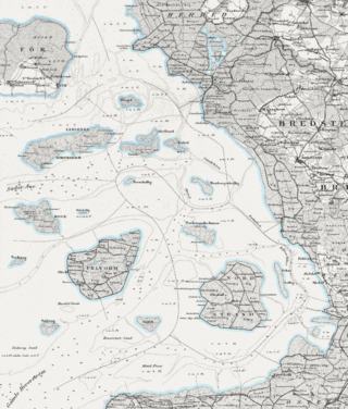
Hainshallig was a small Hallig in the North Frisian Wadden Sea, located east of the Hallig of Hooge, that was flooded and sank in 1860. At the time, Hainshallig was leased to a Hooge resident as part of a leasehold estate and was used for the production of hay. A levee may have once led from Hooge to Hainshallig. The area belonged to the Duchy of Schleswig, which was a fiefdom of the Danish crown, now Germany.

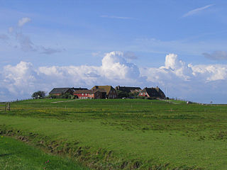
Hamburger Hallig is an area on the westcoast of Nordfriesland district in Schleswig-Holstein, Germany, that is not protected by sea dikes. It is therefore counted among the Halligen islands.