Baltrum

Last updated
Baltrum
Luftaufnahme Baltrum-2.jpg
Aerial view of Baltrum from the west
Flagge Baltrum.svg
DEU Baltrum COA.svg
Location of Baltrum within Aurich district
Baltrum in AUR.svgNorden
Germany adm location map.svg
Red pog.svg
Baltrum
Lower Saxony location map.svg
Red pog.svg
Baltrum
Coordinates: 53°43′44″N07°22′06″E / 53.72889°N 7.36833°E / 53.72889; 7.36833
Country Germany
State Lower Saxony
District Aurich
Government
   Mayor (202025) Harm Olchers [1] (Ind.)
Area
  Total6.50 km2 (2.51 sq mi)
Elevation
5 m (16 ft)
Population
 (2021-12-31) [2]
  Total598
  Density92/km2 (240/sq mi)
Time zone UTC+01:00 (CET)
  Summer (DST) UTC+02:00 (CEST)
Postal codes
26579
Dialling codes 04939
Vehicle registration AUR
Website www.baltrum.de

Baltrum (Low German : Baltrum) is a barrier island off the coast of East Frisia (German : Ostfriesland), in Germany, and is a municipality in the district of Aurich, Lower Saxony. It is located in-between the chain of the seven inhabited East Frisian Islands. Baltrum is the smallest island in this chain by area and inhabitants. It has a land area of 6.5 square kilometres, and a population in (2011) of just over 500 resident inhabitants.

Contents

Geography

It is located in the middle of the island chain known as the East Frisian Islands (German : Ostfriesische Inseln) and is the smallest permanently inhabited island in the chain according to the area and number of inhabitants. The gat or tidal channel of Wichter Ee in the west separates Baltrum from Norderney and the tidal creek Accumer Ee in the east separates it from Langeoog. There are two villages on the island – Ostdorf (English: Eastern village) and Westdorf (English: Western village) – although they have essentially merged into one. The ferry for Baltrum departs from the small port near the village of Neßmersiel (in the parish of Dornum) with connection to the train station of Norden. The island has its own ferry terminal and a small airstrip.

The island is about 5 kilometres (3.1 mi) long and 1.5 kilometres (0.93 mi) wide. It covers an area of 6.5 square kilometres (2.5 sq mi) and has a population of around 600 people, swelling to about 3,500 during the summer months due to tourism. Tourists (mainly from the Ruhr Area in North Rhine-Westphalia) travel to Baltrum to enjoy the countryside of the Lower Saxony Wadden Sea National Park, the beach and attractions such as the indoor swimming pool filled with sea water or a miniature golf course. The highest point on the island is a central coastal dune with a viewing platform on top called Aussichtsdüne in German and is 19.3 metres (63 ft) above sea-level. [3]

Etymology

The origin of the name Baltrum is not clearly clarified. In 1398, the island was mentioned for the first time in a document of enfeoffment as Balteringe meaning either "pasture" or "[the place of] the sons or followers of Balter" in Old Frisian. Another assumption is that the name is derived from the Norse god Baldr – son of Odin and Frigg. In the recent past an ironic version arose, one would be bald 'rum (English: soon around) when encircling the island, as the island is small it would not take a long time to walk around Baltrum. Nevertheless, the circumference amounts to about 15 kilometres (9.3 mi).

History

Location of Baltrum within the East Frisian Islands Ostfriesische Inseln (Karte).png
Location of Baltrum within the East Frisian Islands
Map of Baltrum by Karl Ludwig von Lecoq 1805 with the village Baltrum 1805.jpg
Map of Baltrum by Karl Ludwig von Lecoq 1805 with the village

The geographers Strabo and Pliny the Elder provide an indication that the island existed since the first century BC and AD.[ citation needed ] During the era of the East Frisian chieftains, from 1350 to 1464, the East Frisian islands belonged to the powerful family tom Brok. In 1398 Baltrum was mentioned in a document for the first time, when Widzel tom Brok assigned Balteringe (besides the other islands) to Duke Albert I of Bavaria and received them back as fief.

In the 17th century Baltrum had an elongated shape similar to the present shape of the barrier islands Norderney and Juist. Through the centuries Baltrum lost a huge amount of land at its west coast due to wind and sea conditions which the extension at the east coast could not compensate. Between 1650 and 1960 the island moved about 5 kilometres (3.1 mi) at its west side to east, whereas the east coast moved only 1.5 kilometres (0.93 mi) to east. A journey from a committee in 1650 reports that the 14 inhabitants on the island of that time were in jeopardy by the sea. In 1737 there was a village with a church which had to be abandoned due to silting[ clarification needed ] of shifting sand dunes in 1800. The new village, named Western village, was settled down around 800 metres (2,600 ft) to the west of the present day west coast (near the present day shoal Othelloplate in-between Baltrum and Norderney) and in the east there was the Eastern village. A storm surge in 1825 disrupted the island in several pieces and it became mostly uninhabitable, followed by deserting the Western village.

From 1870 onwards the island was protected against the power of the sea with groynes, wooden palisades and revetments. Furthermore, are levees protecting the built-up area against floodings.

On the island exist no official street names but house numbers, instead. Currently (retrieved 2009), are about 300 numbers assigned to houses. The numbering is based on the date of the house construction in ascending order. So the numbers reveal some history of the buildings on the island. However the numbers do not change if a building is replaced by a newer construction.

Tourism

Beach of Baltrum Baltrum Strand.jpg
Beach of Baltrum

Although Baltrum became a seaside resort in 1876, the tourism grew very slowly. Since 1966 Baltrum has been a seaside health resort approved by the state of Germany. Two hotels were opened in the end of the 19th century, Hotel Küper in 1892 and Hotel zur Post in 1895. Before the World War II broke out 5,000 to 6,000 people visited Baltrum annually. In 1960 nearly 17,000 tourists showed up and since the 1970s there are over 30,000 people making holidays every year during the peak season. Besides the approximately 500 inhabitants about 3,000 guests are constantly living on the island during the peak seasons exhausting the acceptance capacity of the two small villages.

Points of interest

Traffic

Car-free Baltrum Baltrum Autofrei.jpg
Car-free Baltrum

Baltrum is a completely car-free island, because of the traffic ban of all kind of motor vehicles. The only exceptions are vehicles of the volunteer fire department, an ambulance, a few wheel loaders and some machines needed for the coastal protection. From 1949 until 1985 there was a small single track Inselbahn Baltrum (English: Baltrum Island Railway) which was an unelectrified narrow gauge railway [5] for baggage and cargo transportation. No bicycle sharing system exists on Baltrum and the tourists are asked not to bring their own bicycles onto the island, riding bicycles is the privilege of inhabitants. The passenger and freight transportation is accomplished by horse-drawn carriages. The baggage is transported by two-wheeled or four-wheeled carts or also carriages, use of electrical bicycles is the latest trend.

There are no street names on Baltrum, and postal addresses are related to the chronology of the development of the areas meaning that the numbering is geographically independent.

There is a search and rescue station presently on Baltrum which is operated by the German Maritime Search and Rescue Service.

Transport

Ferry services

Baltrum is tidal independent laid by ferries owned by the shipping company Baltrum Line, founded in 1928, starting in Neßmersiel. The journey takes about 30 minutes and depending on the season and tourist season one ferry leaves once up to four times for each direction daily. The baggage is containerized and transported in the same ferry as the vacationers. The highlights of the passage are the seals on the shoals ahead of Norderney passed by the ferry. The shipping company manages a bus connection to the train station of Norden, Lower Saxony. Until 2006 the freight traffic was accomplished with the ferry Baltrum II via the port in Norddeich, Lower Saxony, but since then is transacted via the port in Neßmersiel. The port of Neßmersiel was inaugurated in 1970 and extended by a cargo wharf with 35 metres (115 ft) in length from April to August 2008 due to the relocation of the freight transportation.

Airport

Baltrum Airstrip Baltrum Flughafen.jpg
Baltrum Airstrip

The airstrip on Baltrum achieves the connection by air to Norddeich.

Walk

At the event of low water Baltrum is reachable from the port of Neßmersiel as a guided walk across the mudflats taking 2.5 hours.

Literature

Related Research Articles

<span class="mw-page-title-main">Lower Saxony</span> State in Germany

Lower Saxony is a German state in northwestern Germany. It is the second-largest state by land area, with 47,614 km2 (18,384 sq mi), and fourth-largest in population among the 16 Länder federated as the Federal Republic of Germany. In rural areas, Northern Low Saxon and Saterland Frisian are still spoken, albeit in declining numbers.

<span class="mw-page-title-main">Aurich (district)</span> District in Lower Saxony, Germany

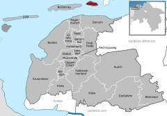
Aurich is a district (Landkreis) in Lower Saxony, Germany. It is bounded by the North Sea, the districts of Wittmund and Leer, and the city of Emden.

<span class="mw-page-title-main">East Frisian Islands</span> Chain of German islands in the North Sea

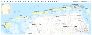
The East Frisian Islands are a chain of islands in the North Sea, off the coast of East Frisia in Lower Saxony, Germany. The islands extend for some 90 kilometres (56 mi) from west to east between the mouths of the Ems and Jade / Weser rivers and lie about 3.5 to 10 km offshore. Between the islands and the mainland are extensive mudflats, known locally as Watten, which form part of the Wadden Sea. In front of the islands are Germany's territorial waters, which occupy a much larger area than the islands themselves. The islands, the surrounding mudflats and the territorial waters form a close ecological relationship. The island group makes up about 5% of the Lower Saxony Wadden Sea National Park.

<span class="mw-page-title-main">East Frisia</span> Historic region in Lower Saxony, Germany

East Frisia or East Friesland is a historic region in the northwest of Lower Saxony, Germany. It is primarily located on the western half of the East Frisian peninsula, to the east of West Frisia and to the west of Landkreis Friesland.

<span class="mw-page-title-main">Borkum</span> Municipality in Lower Saxony, Germany

Borkum is an island and a municipality in the Leer District in Lower Saxony, northwestern Germany. It is situated east of Rottumeroog and west of Juist.

<span class="mw-page-title-main">Nordenham</span> Town in Lower Saxony, Germany

Nordenham is a town in the Wesermarsch district, in Lower Saxony, Germany. It is located at the mouth of the Weser river on the Butjadingen peninsula on the coast of the North Sea. The seaport city of Bremerhaven is located on the other side of the river. The Midgard-seaport in Nordenham is the largest private-owned harbor in Germany.

<span class="mw-page-title-main">Dagebüll</span> Municipality in Schleswig-Holstein, Germany

Dagebüll is a municipality located at the west coast of Schleswig-Holstein in the Nordfriesland district, Germany. Today's Dagebüll was created in 1978 as a merger of the municipalities of Fahretoft, Juliane-Marien-Koog and Waygaard. Dagebüll used to be a Hallig, the oldest houses were built on artificial dwelling hills which in parts can still be seen today. In 1704 the area was secured by sea dikes.

<span class="mw-page-title-main">Butjadingen</span> Municipality in Lower Saxony, Germany

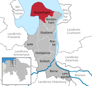
Butjadingen is a peninsula and municipality in the Wesermarsch district, in Lower Saxony, Germany.

<span class="mw-page-title-main">Norderney</span> Town in Lower Saxony, Germany

Norderney is one of the seven populated East Frisian Islands off the North Sea coast of Germany.

<span class="mw-page-title-main">Norden, Lower Saxony</span> Town in Lower Saxony, Germany

Norden is a town in the district of Aurich, in Lower Saxony, Germany. It is situated near the North Sea shore, in East Frisia.

<span class="mw-page-title-main">Juist</span> Municipality in Lower Saxony, Germany

Juist is an island and municipality in the district of Aurich in Lower Saxony in Germany. The island is one of seven East Frisian Islands at the edge of the Lower Saxon Wadden Sea in the southern North Sea. It is located between Borkum Island (west), Memmert Island (southwest) and Norderney (east). The island is 17 km (11 mi) long and from 500 metres (1,600 ft) to 1 kilometre (0.62 mi) wide, depending on the tide levels. There are two villages on the island: the main village Juist, and Loog. The island is separated from Norderney by the Norderneyer Seegatt.

<span class="mw-page-title-main">Wangerooge</span> Municipality in Lower Saxony, Germany

Wangerooge is one of the 32 Frisian Islands in the North Sea located close to the coasts of the Netherlands, Germany and Denmark. It is also a municipality in the district of Friesland in Lower Saxony in Germany.

<span class="mw-page-title-main">Langeoog</span> Municipality in Lower Saxony, Germany

Langeoog is one of the seven inhabited East Frisian Islands at the edge of the Lower Saxon Wadden Sea in the southern North Sea, located between Baltrum Island (west), and Spiekeroog (east). It is also a municipality in the district of Wittmund in Lower Saxony, Germany. The name Langeoog means Long Island in the Low German dialect.

<span class="mw-page-title-main">Spiekeroog</span> Municipality in Lower Saxony, Germany

Spiekeroog is one of the East Frisian Islands, off the North Sea coast of Germany. It is situated between Langeoog to its west, and Wangerooge to its east. The island belongs to the district of Wittmund, in Lower Saxony in Germany. The only village on the island is also called Spiekeroog. The island is part of the Wadden Sea World Heritage Site by the UNESCO and the Lower Saxon Wadden Sea National Park.

<span class="mw-page-title-main">Neßmersiel</span>

Neßmersiel belongs to the municipality Dornum in the rural district Aurich in Lower Saxony, Germany. Neßmersiel is located about 5 kilometres northwest of Dornum. From 1867 to 1977, Neßmersiel belonged to Norden.

<span class="mw-page-title-main">Wyk auf Föhr</span> Town in Schleswig-Holstein, Germany

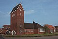
Wyk auf Föhr is the only town on Föhr, the second largest of the North Frisian Islands on the German coast of the North Sea. Like the entire island it belongs to the district of Nordfriesland. Wyk includes the two minor town districts of Boldixum and Südstrand.

<span class="mw-page-title-main">Lower Saxon Wadden Sea National Park</span> National Park in Lower Saxony, Germany

The Lower Saxon Wadden Sea National Park was established in 1986 and embraces the East Frisian Islands, mudflats and salt marshes between the Bay of Dollart on the border with the Netherlands in the west and Cuxhaven as far as the Outer Elbe shipping channel in the east. The national park has an area of about 345,800 hectares (1,335 sq mi). The National Park organisation is located in Wilhelmshaven. In June 2009, the National Park became a UNESCO World Heritage Site along with the Schleswig-Holstein Wadden Sea and the Dutch Wadden Sea, highlighting its unique intertidal ecosystem and high biodiversity.

<span class="mw-page-title-main">Norddeich (Norden)</span> Ortsteil of Norden in Lower Saxony, Germany

Norddeich is a village in the borough of Norden in north Germany with 1,540 inhabitants (2011). It lies in northwestern East Frisia, Lower Saxony on the North Sea coast.

<span class="mw-page-title-main">Oldenburg–Leer railway</span>

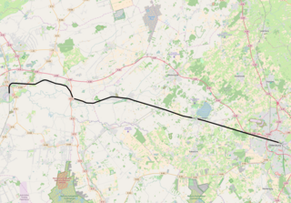
The Oldenburg–Leer railway is a 55 km (34 mi) single-track electrified main line in the north-west of the German state of Lower Saxony. It connects the Emsland line near Leer with the city of Oldenburg. Thus, it serves traffic from the direction of Hanover and Bremen to the port of Emden, the Emsland and western East Frisia, including the islands of Borkum, Juist and Norderney, which are important tourist destinations. Together with the Leer–Groningen line, it also has international significance.

References

  1. "Verzeichnis der direkt gewählten Bürgermeister/-innen und Landräte/Landrätinnen". Landesamt für Statistik Niedersachsen. April 2021.
  2. "LSN-Online Regionaldatenbank, Tabelle A100001G: Fortschreibung des Bevölkerungsstandes, Stand 31. Dezember 2021" (in German). Landesamt für Statistik Niedersachsen.
  3. "Niedersachsen Karte – Stadtplan 1:25.000 für exakte Planungen" (in German). Behörde für Geoinformation, Landentwicklung und Liegenschaften (GLL) des Bundeslandes Niedersachsen. Archived from the original on 26 March 2009. Retrieved March 25, 2009.
  4. "Deckwerkssanierung Baltrum" (in German). Niedersächsischer Landesbetrieb für Wasserwirtschaft, Küsten- und Naturschutz (NLWKN). January 15, 2009. Retrieved March 22, 2009.
  5. "Zustand und Zukunft des Bahnverkehrs in Niedersachsen" (PDF) (in German). Niedersächsisches Ministerium für Wirtschaft, Arbeit und Verkehr, Niedersächsischer Landtag. September 2, 2008. p. 19. Archived from the original (PDF) on 19 July 2011. Retrieved June 20, 2011.