Many ancient camps, and many tumuli, are found in Lauderdale.[1] The Roman road into Scotland, Dere Street, which means "the road into the country of the wild animals", crossed a ford at Newstead, near Melrose, where there had been a Roman fort and garrison, and entered Lauderdale. Dere Street is said to have been reconditioned by King Malcolm Canmore and probably used by him in his almost constant warfare against England. The Roman road has now been traced from the Tweed through Lauderdale to Soutra.[2]
Etymology
Lauderdale's name comes from the town of Lauder rather than the Leader Water.[3] The relationship between the names "Leader" and "Lauder" is very obscure; despite their similarity, they may have different origins.[4] Alternatively, they may both go back to a Britonnic root meaning "cleansing water".[5] The name of the valley is first attested in the late 12th century as Lauuedderdale.[3]
Medieval period
Symeon of Durham (d. c1130) claimed that the "land beyond the Tweed from the place where rises the river Whiteadder on the north as far as to the place where it falls into the Tweed; and all the land which lies between the river Whiteadder and another river which is called the Leader towards the west; and all the land which lies on the eastern side of that river called the Leader, as far as to the place where it falls into the Tweed towards the south; and all the land which pertains to the monastery of St. Baldred called Tyninghame, from Lammermoor even to Eskmouth, pertains to the land of Lindisfarne."[6]
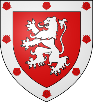
King David I of Scotland created a feudal Lordship of Regality of Lauderdale which he awarded to one of his favourites, the Anglo-NormanHugh de Morville (d. 1162), whom he also made Constable of Scotland. The boundaries of his fief are still unclear, but the town existed before de Morville's arrival,[7] the Lauder family already holding various lands direct from the Crown prior to this, part of which was the estate attached to Whitslaid Tower. The de Morvilles of Lauderdale failed in the male line and their Lordship passed by marriage to Alan of Galloway, and a charter exists of "Alani constabularii Scotie, de Alwentchawis" (Allanshaws) in which mention is also made of "terras in territorio de Lauuedir".[8] The Lordship passed to his grandson, John Balliol, and after his forfeiture Robert The Bruce granted it to Sir James Douglas, his great supporter. Archibald Douglas husband of Princess Margaret, daughter of King Robert III, had a reconfirmation c1390 of the Lordship of "Lauderdaill" as heir of the Earl of Douglas. Archibald is herein also called "Lord of Galloway, Lord of Annandale, and of Lowedre".[9] Finally the Douglases were also forfeited.
Towards the southern end of Lauderdale is the town of Earlston, an ancient superiority of the Earls of Dunbar or March. "Robertus de Lauuedirr tunc noster seneschallus" witnessed a charter of "Patricii de Dunbar, comitis Marchie" during the reign of Robert the Bruce, and "Robetus de Lawedre, consanguineus noster" (a cousin) witnessed a charter of "Georgii comitis Marchie" relating to Sorrowlessfield, a still extant property on the (A68) road south of Earlston in the reign of Robert III.[10]
Geography
Fields in Lauderdale
Southern Lauderdale could be considered to commence in the vicinity of Newstead. In the north Lauderale ends at part of the Lammermuir Hills where they reach 1733 feet,[11] where in winter the weather can be severe, often leading to road closures. The full length of Lauderdale exceeds ten miles (16km) and its breadth varies from three to seven miles.[11]
Up until the 17th century Lauderdale was an immense forest. From the time of Malcolm Canmore, at least, it was a Royal hunting ground. The entire district between the Leader and Gala Waters was covered with Lauder forest,[12] "the property of the Lauders of Lauder from a very early date"[13] and which was still in the possession of the family of Lauder of that Ilk through to the late 17th century.[14][15]
Today Lauderdale is almost completely agricultural.
The Scottish Borders is one of 32 council areas of Scotland. It is bordered by West Lothian, Edinburgh, Midlothian, and East Lothian to the north, the North Sea to the east, Dumfries and Galloway to the south-west, South Lanarkshire to the west, and the English ceremonial counties of Cumbria and Northumberland to the south. The largest settlement is Galashiels, and the administrative centre is Newtown St Boswells.
The A68 is a major road in the United Kingdom, running from Darlington in England to the A720 in Edinburgh, the capital of Scotland. It crosses the Anglo-Scottish border at Carter Bar and is the only road to do so for some distance either way; the next major crossings are the A697 from Coldstream to Cornhill-on-Tweed in the east, and the A7 near Canonbie to the west.
Berwickshire is a historic county, registration county and lieutenancy area in south-eastern Scotland, on the English border. The county takes its name from Berwick-upon-Tweed, its original county town, which was part of Scotland at the time of the county's formation in the twelfth century, but became part of England in 1482 after several centuries of swapping back and forth between the two kingdoms. After the loss of Berwick, Duns and Greenlaw both served as county town at different periods.
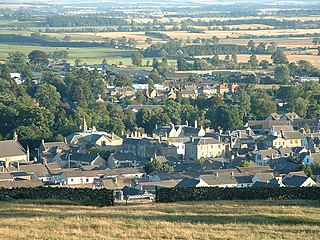
The former Royal Burgh of Lauder is a town in the Scottish Borders in the historic county of Berwickshire. On the Southern Upland Way, the burgh lies 27 miles (43 km) southeast of Edinburgh, on the western edge of the Lammermuir Hills.
Duns is a town in the Scottish Borders, Scotland. It was the county town of the historic county of Berwickshire.
The Lammermuirs are a range of hills in southern Scotland, forming a natural boundary between East Lothian and the Borders. The name "Lammermuir" comes from the Old English lambra mōr, meaning "moorland of the lambs".
Patrick de Dunbar, 9th Earl of March, was a prominent Scottish magnate during the reigns of Robert the Bruce and David II.
Dryburgh Abbey, near Dryburgh on the banks of the River Tweed in the Scottish Borders, was nominally founded on 10 November (Martinmas) 1150 in an agreement between Hugh de Morville, Constable of Scotland, and the Premonstratensian canons regular from Alnwick Abbey in Northumberland. The arrival of the canons along with their first abbot, Roger, took place on 13 December 1152.
Earlston is a civil parish and market town in the county of Berwickshire, within the Scottish Borders. It is on the River Leader in Lauderdale, Scotland.
Whiteadder Water is a river in East Lothian and Berwickshire, Scotland. It also flows for a very short distance through Northumberland before joining the River Tweed. In common with the headwaters of the Biel Water it rises on the low hillside of Clints Dod in the Lammermuir Hills, just ESE of Whitecastle Hillfort and 3 km (1.9 mi) south-east of the village of Garvald.
Hugh de Morville of Appleby in Westmorland, England, hereditary Constable of Scotland, was a Norman knight who made his fortune in the service of David FitzMalcolm (d.1153), Prince of the Cumbrians, later King of Scotland.
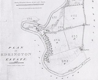
Edrington is a medieval estate occupying the lower part of Mordington parish in Berwickshire, Scottish Borders, Scotland, five miles (8.0 km) west of Berwick-upon-Tweed. From probably the 14th century, if not earlier, a castle occupied the steep hill above the mill of the same name on the Whiteadder Water. The castle ruin is still marked on today's Ordnance Survey maps, and still appears in locality references in The Berwickshire News. The principal farm of the estate is Edrington Mains.
Mordington is an agricultural parish in the extreme south-east of Berwickshire in the Scottish Borders region. It is five miles from Berwick-upon-Tweed and borders Northumberland to the east, and south, Foulden to the west, and Lamberton to the north. The parish is bisected by the A6105 Berwick to Duns road. The lower part of the parish is covered by the Edrington estate. It is possibly the warmest parish in Scotland; the annual hours of sunshine are said to be almost as high as at Dunbar, which records the most hours in Scotland.
Richard de Morville, Lord of Cunninghame succeeded his father, Hugh de Morville, as Constable of Scotland and in his Scottish estates and English lands at Bozeat in Northamptonshire, and Rutland, as well as a number of feus of the Honour of Huntingdon.
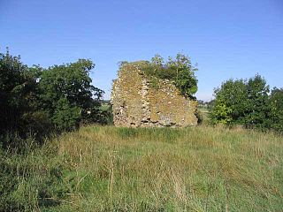
Whitslaid Tower was an ancient Berwickshire seat of the Lauder family for over 300 years. It is today a ruin high above the eastern bank of the Leader Water, 2 miles (3.2 km) south of the burgh of Lauder, in the Scottish Borders. In feudal times it fell within a detached segment of the King's personal Barony of Renfrew.
George de Dunbar, 10th Earl of Dunbar and March (1338–1422), 12th Lord of Annandale and Lord of the Isle of Man, was "one of the most powerful nobles in Scotland of his time, and the rival of the Douglases."
Leader Water is a small tributary of the River Tweed in Lauderdale in the Scottish Borders. It flows southwards from the Lammermuir Hills through the towns of Lauder and Earlston, joining the River Tweed at Leaderfoot.
Channelkirk is a parish and community council area in the north-west corner of the historic county of Berwickshire in the Scottish Borders area of Scotland, forming the upper part of the ancient district of Lauderdale, while the parish of Lauder forms the lower part. The Community Council has the name Oxton and Channelkirk, Oxton being the main village of the parish. It was formerly in the Ettrick and Lauderdale district of Borders Region. A small strip of land along the northern boundary of the parish was added to Ettrick and Lauderdale district and thus also to the community council area, in the Brothershiels area, in 1988.
Carfrae Bastle is a small ruined tower house about 5 miles (8.0 km) north of Lauder, Scottish Borders, Scotland, near Hillhouse
This page is based on this Wikipedia article Text is available under the CC BY-SA 4.0 license; additional terms may apply. Images, videos and audio are available under their respective licenses.