Laurel Canyon Boulevard

Last updated
Laurel Cyn Bl (2024) Laurel Cyn Bl 2024 Feb.jpg
Laurel Cyn Bl (2024)

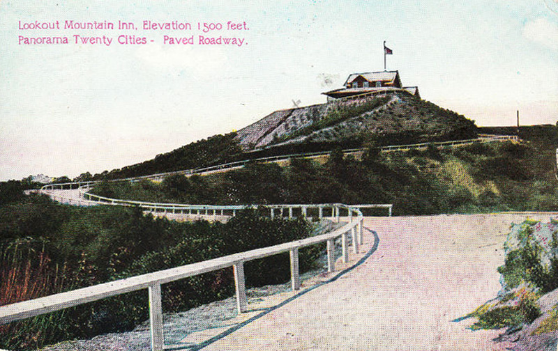
Laurel Canyon Boulevard is a major street in the city of Los Angeles. It starts off at Polk Street in Sylmar in the northern San Fernando Valley near the junction of the San Diego (Interstate 405) and the Golden State (I-5)) freeways. Laurel Canyon Boulevard bypasses the city of San Fernando to the west, running parallel to I-5 in the vicinity of Pacoima and Arleta. The portion through Sun Valley passes through rock quarries and a great deal of open space.

Contents

From the intersection with Webb Avenue, Laurel Canyon Boulevard heads due south, cutting through North Hollywood, closely following the Hollywood Freeway (SR 170). Laurel Canyon Boulevard passes through the Valley Village neighborhood, one mile (1.6 km) west of the Hollywood Split (the intersection of the Hollywood (U.S. 101/SR 170) and Ventura (U.S. 101/SR 134) freeways). This would have been the start of the proposed Laurel Canyon Freeway, which would have provided a direct freeway connection from the southeastern San Fernando Valley to the Los Angeles International Airport. The proposed route was along the current routing of Laurel Canyon Boulevard, but the emergence of the Laurel Canyon neighborhood as a movie star enclave doomed the project, as did local opposition.

Laurel Canyon itself found counterculture fame in the 1960s as home to many of L.A.'s top rock musicians, such as Frank Zappa. The bohemian spirit endures; every year, residents gather for a group photograph at the country market. Laurel Canyon Boulevard was also immortalized by The Doors in their 1968 song "Love Street."

Laurel Canyon Boulevard crosses Laurel Canyon G Line station at its intersection with Chandler Boulevard in Valley Village. Laurel Canyon Boulevard is served by Metro Local lines 218 (south of Ventura Boulevard) and 230 (north of Ventura Boulevard).

South of Ventura Boulevard in Studio City, Laurel Canyon Boulevard ascends the Santa Monica Mountains, where it maintains a width of four lanes until the intersection of Mulholland Drive. The road climbs up Lookout Mountain before descending into West Hollywood, passing through Hollywood Boulevard. Laurel Canyon Boulevard’s southern terminus is at its intersection with Sunset Boulevard and Crescent Heights Boulevard.

Laurel Canyon Boulevard and Coldwater Canyon Avenue to the west between the southern San Fernando Valley and West Hollywood are also popular alternate routes to the Hollywood Freeway (US 101) during rush hour.

Laurel Canyon Freeway

The Laurel Canyon Freeway was to have been a north-south freeway in Central Los Angeles and its suburbs. It derived its name from Laurel Canyon, the proposed route by which the freeway would traverse the Santa Monica Mountains.

Its proposed alignment was from the intersection of the Hollywood Freeway (U.S. Route 101) and the Ventura Freeway (California State Route 134) in the southeastern San Fernando Valley — to the San Diego Freeway (I-405) near Los Angeles International Airport. [1]

However, the emerging popularity of Laurel Canyon as a movie star enclave in the 1960s ultimately doomed the project. The only portion of the freeway that was built was a small section of La Cienega Boulevard through the Baldwin Hills district of southwestern Los Angeles. [2]

History

Early trackless trolley, 1910s Cyclopedia of applied electricity - a general reference work on direct-current generators and motors, storage batteries, electrochemistry, welding, electric wiring, meters, electric lighting, electric (14780081682).jpg
Early trackless trolley, 1910s

In 1919 Harry Houdini rented the cottage [upper-alpha 1] at 2435 Laurel Canyon Boulevard, while making movies for Lasky Pictures. His wife occupied it for a time after his death. As of 2011 that site was a vacant lot. [3] The main mansion building itself was rebuilt after it was destroyed in the 1959 Laurel Canyon fire, [4] and is now a historic venue. [5] While Houdini did not likely live at the "mansion," there is some probability that his widow did. [6]

Related Research Articles

<span class="mw-page-title-main">San Fernando Valley</span> Valley in California, US

The San Fernando Valley, known locally as the Valley, is an urbanized valley in Los Angeles County, California. Situated to the north of the Los Angeles Basin, it contains a large portion of the city of Los Angeles, as well as several unincorporated areas; and the incorporated cities of Burbank, Calabasas, Glendale, Hidden Hills, and San Fernando. The valley is well known for its film studios such as Warner Bros. Studios and Walt Disney Studios. In addition, it is home to the Universal Studios Hollywood theme park.

<span class="mw-page-title-main">Mulholland Drive</span> Street and road in Southern California

Mulholland Drive is a street and road in the eastern Santa Monica Mountains of Southern California. It is named after pioneering Los Angeles civil engineer William Mulholland. The western rural portion in Los Angeles and Ventura Counties is named Mulholland Highway. The road is featured in a significant number of films, songs, and novels. David Lynch, who wrote and directed a film named after Mulholland Drive, has said that one can feel "the history of Hollywood" on it. Jack Nicholson has lived on Mulholland Drive for many years, and still did so as of 2009.

<span class="mw-page-title-main">Interstate 405 (California)</span> Interstate Highway in California

Interstate 405 is a major north–south auxiliary Interstate Highway in Southern California. The entire route is known as the northern segment of the San Diego Freeway. I-405 is a bypass auxiliary route of I-5, running along the southern and western parts of the Greater Los Angeles urban area from Irvine in the south to Sylmar in the north.

<span class="mw-page-title-main">Hollywood Freeway</span> Freeway in California

The Hollywood Freeway is one of the principal freeways of Los Angeles, California and one of the busiest in the United States. It is the principal route through the Cahuenga Pass, the primary shortcut between the Los Angeles Basin and the San Fernando Valley. It is considered one of the most important freeways in the history of Los Angeles and instrumental in the development of the San Fernando Valley. It is the second oldest freeway in Los Angeles. From its southern end at the Four Level Interchange to its intersection with the Ventura Freeway in the southeastern San Fernando Valley, it is signed as part of U.S. Route 101. It is then signed as State Route 170 north to its terminus at the Golden State Freeway.

<span class="mw-page-title-main">Ventura Freeway</span> Freeway in Southern California

The Ventura Freeway is a freeway in southern California, United States, that runs from the Santa Barbara/Ventura county line to Pasadena in Los Angeles County. It is the principal east–west route through Ventura County and in the southern San Fernando Valley in Los Angeles County. From the Santa Barbara County line to its intersection with the Hollywood Freeway in the southeastern San Fernando Valley in Los Angeles, it is signed as U.S. Route 101 (US 101), which was built in the late 1950s and opened on April 5, 1960. The segments from the Santa Barbara County line to Sea Cliff, and from Solimar Beach to Oxnard, are also concurrent with State Route 1 (SR 1), although no signs mention SR 1 there. East of the Hollywood Freeway intersection, the Ventura Freeway is signed as State Route 134 (SR 134), which was built by 1971.

<span class="mw-page-title-main">Ventura Boulevard</span> Thoroughfare in San Fernando Valley

Ventura Boulevard is one of the primary east–west thoroughfares in the San Fernando Valley region of the City of Los Angeles, California. Ventura Boulevard is one of the oldest routes in the San Fernando Valley as it is along the commemorative route El Camino Real. It was also U.S. Route 101 (US 101) before the freeway was built, and it was also previously signed as U.S. Route 101 Business.

<span class="mw-page-title-main">California State Route 2</span> State highway in California, United States

State Route 2 (SR 2) is a state highway in the U.S. state of California. It connects the Los Angeles Basin with the San Gabriel Mountains and the Victor Valley in the Mojave Desert. The highway's southwestern end is at the intersection of Centinela Avenue at the Santa Monica-Los Angeles border and its northeastern end is at SR 138 east of Wrightwood. The SR 2 is divided into four segments, and it briefly runs concurrently with U.S. Route 101 (US 101) and Interstate 210 (I-210). The southwestern section of SR 2 runs along a segment of the east–west Santa Monica Boulevard, an old routing of US 66, to US 101 in East Hollywood; the second section runs along segments of both the north–south Alvarado Street and Glendale Boulevard in Echo Park; the third section to I-210 in Glendale is known as the north–south Glendale Freeway; and the northeastern portion from I-210 in La Cañada Flintridge to SR 138 is designated as the Angeles Crest Highway.

<span class="mw-page-title-main">Colorado Boulevard</span> Major east–west street in Los Angeles County, Southern California

Colorado Boulevard is a major east–west street in Southern California. It runs from Griffith Park in Los Angeles east through Glendale, the Eagle Rock section of Los Angeles, Pasadena, and Arcadia, ending in Monrovia. The full route was once various state highways but is now locally maintained in favor of the parallel Ventura Freeway and Foothill Freeway (I-210).

<span class="mw-page-title-main">California State Route 118</span> Highway in California

State Route 118 is a state highway in the U.S. state of California that runs west to east through Ventura and Los Angeles counties. It travels from State Route 126 at the eastern edge of Ventura immediately northwest of Saticoy, then through Saticoy, in Ventura County east to Interstate 210 near Lake View Terrace in Los Angeles. SR 118 crosses the Santa Susana Pass and the northern rim of the San Fernando Valley along its route.

<span class="mw-page-title-main">Southern California freeways</span> Freeway system

The Southern California freeways are a vast network of interconnected freeways in the megaregion of Southern California, serving a population of 23 million people. The Master Plan of Metropolitan Los Angeles Freeways was adopted by the Regional Planning Commission in 1947 and construction began in the early 1950s. The plan hit opposition and funding limitations in the 1970s, and by 2004, only some 61% of the original planned network had been completed.

<span class="mw-page-title-main">La Cienega Boulevard</span> Highway in California

La Cienega Boulevard is a major north–south arterial road in the Los Angeles metropolitan area that runs from El Segundo Boulevard in Hawthorne to the Sunset Strip in West Hollywood to the north. It was named for Rancho Las Cienegas, literally "The Ranch Of The Swamps," an area of marshland south of Rancho La Brea.

<span class="mw-page-title-main">Sepulveda Boulevard</span> Street in Los Angeles, California

Sepulveda Boulevard is a major street and transportation corridor in the City of Los Angeles and several other cities in western Los Angeles County, California. The street parallels Interstate 405 for much of its route. Portions of Sepulveda Boulevard between Manhattan Beach and Los Angeles International Airport (LAX) are designated as part of State Route 1.

<span class="mw-page-title-main">Topanga Canyon Boulevard</span> Highway in California

State Route 27, commonly known by its street name Topanga Canyon Boulevard, is a state highway in the U.S. state of California that runs from the Pacific Coast Highway at Topanga State Beach near Pacific Palisades, through the Topanga Canyon in Topanga, and continuing through Woodland Hills, Canoga Park, West Hills, and Chatsworth to the Ronald Reagan Freeway.

<span class="mw-page-title-main">Santa Monica Boulevard</span> East-west thoroughfare in Los Angeles, California, United States

Santa Monica Boulevard is a major west–east thoroughfare in Los Angeles County, California, United States. It runs from Ocean Avenue in Santa Monica near the Pacific Ocean to Sunset Boulevard at Sunset Junction in Los Angeles. It passes through Beverly Hills and West Hollywood. A portion of it is designated as California State Route 2, while the full avenue was Historic Route 66.

<span class="mw-page-title-main">U.S. Route 101 in California</span> U.S. Highway in California

U.S. Route 101 (US 101) is a major north–south United States Numbered Highway, stretching from Los Angeles, California, to Tumwater, Washington. The California portion of US 101 is one of the last remaining and longest U.S. Routes still active in the state, and the longest highway of any kind in California. US 101 was also one of the original national routes established in 1926. Significant portions of US 101 between the Los Angeles area and the San Francisco Bay Area follow El Camino Real, the commemorative route connecting the former Alta California's 21 missions.

<span class="mw-page-title-main">San Fernando Road</span> Major street in the City and County Los Angeles

San Fernando Road is a major street in the City of Los Angeles and Los Angeles County. Within the Burbank city limits it is signed as San Fernando Boulevard, and north of Newhall Pass it is signed as The Old Road. It was previously designated as Business Loop 5 in the 1970s.

Foothill Boulevard is a major road in the city and county of Los Angeles, as well as an arterial road in the city and county of San Bernardino, stretching well over 60 miles (97 km) in length, with some notable breaks along the route. Like its name implies, Foothill Boulevard runs across the foothills of the San Gabriel and San Bernardino Mountains.

The Hollywood Split is a freeway interchange in the San Fernando Valley area of Los Angeles, California. The interchange is officially named in the memory of California Highway Patrol officer Bruce T. Hinman, who was killed by a drunk driver. It is the interchange of the following routes:

<span class="mw-page-title-main">Lankershim Boulevard</span> Thoroughfare in San Fernando Valley

Lankershim Boulevard is a major north-south thoroughfare in the eastern San Fernando Valley, primarily within the City of Los Angeles, in Los Angeles County, California.

References

Notes

  1. "Not the home, which was sensationally dubbed "the Houdini mansion" when it burned in 1959. [3] It should not be confused with houses of Houdini.

Citations

  1. Washington, Colin Cab - 4 freeways that did not get built in LA (and why) KCRW December 22, 2017
  2. Ballard, Michael F. - La Cienega Boulevard – Baldwin Hills
  3. 1 2 "Houdini's Homes: Houdini owned homes in New York and California". magictricks.com. Retrieved January 23, 2017.
  4. "Laurel Canyon Fire, July 10, 1959".
  5. "Welcome to the Houdini Estate". The Houdini Estate. Archived from the original on February 6, 2017. Retrieved February 5, 2017.
  6. Cox, John (March 30, 2012). "Inside the Laurel Canyon Houdini Estate". Wild About Harry. Retrieved February 5, 2017.
KML is not from Wikidata