Jefferson Boulevard

Last updated
Jefferson Boulevard
Location Los Angeles and Culver City, California
Nearest metro station LAMetroLogo.svg
West end Culver Boulevard in Playa Del Rey
East end Central Avenue in Los Angeles
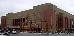
USC Trojans' Galen Center at Jefferson Blvd. and Figueroa St. 11-11-06-GalenCenter.jpg
USC Trojans' Galen Center at Jefferson Blvd. and Figueroa St.
Shrine Auditorium Shrine Auditorium.jpg
Shrine Auditorium

Jefferson Boulevard is a street in Los Angeles and Culver City, California. Its eastern terminus is at Central Avenue east of Exposition Park. At its entrance to Culver City, it splits with National Boulevard. North of Sawtelle Boulevard, it merges with Sepulveda Boulevard. Jefferson returns before Slauson Avenue and ends at Culver Boulevard; its western terminus is near Playa Del Rey.

Contents

Education and transportation

University of Southern California (USC) is located on Jefferson Boulevard from Figueroa Street to Vermont Avenue. Its sports center complex, the Galen Center, is located at the southeast corner of Jefferson and Figueroa.

Bus service is operated through Jefferson Boulevard between Playa Vista and West L.A. Transit Center by Culver City Transit line 4, between West LA Transit Center and USC by Metro Local line 38, and east of USC by Metro Local line 102. The Metro E Line serves two light rail stations at Jefferson: one at Flower Street near USC and the other on La Cienega Boulevard. [1]

Little New Orleans

Los Angeles saw an influx of Creoles of color to the area in the mid-1900s, to the point that by the 1950s a portion of Jefferson Boulevard and Jefferson Park (a neighborhood that ran partially along Jefferson Boulevard) was unofficially dubbed "Little New Orleans". [2] The population was predominantly Creole and held many Creole-owned businesses such as the Big Loaf Bakery, which was considered to be the "only place in Los Angeles that made New Orleans style Baguettes". [3] [4]

Notable landmarks

Related Research Articles

<span class="mw-page-title-main">Culver City, California</span> City in Los Angeles County, California, US

Culver City is a city in Los Angeles County, California, United States. As of the 2020 census, the population was 40,779.

<span class="mw-page-title-main">West Adams, Los Angeles</span> Neighborhood of Los Angeles in California, United States

West Adams is a historic neighborhood in the South Los Angeles region of Los Angeles, California. The area is known for its large number of historic buildings, structures and notable houses and mansions. It contains several Historic Preservation Overlay Zones as well as designated historic districts.

<span class="mw-page-title-main">Exposition Park (Los Angeles)</span> Public park in Los Angeles

Exposition Park is a 160-acre urban park (65 ha) in the south region of Los Angeles, California, in the Exposition Park neighborhood. Established in 1872 as an agricultural fairground, the park includes the Los Angeles Memorial Coliseum, BMO Stadium, the California Science Center, the Natural History Museum of Los Angeles County, and the California African American Museum. The Lucas Museum of Narrative Art is under construction. Bounded by Exposition Boulevard to the north, South Figueroa Street to the east, Martin Luther King Jr. Boulevard to the south and Vermont Avenue to the west, it is directly south of the main campus of the University of Southern California.

<span class="mw-page-title-main">Jefferson Park, Los Angeles</span> Neighborhood of Los Angeles in California, United States

Jefferson Park is a neighborhood in the South Los Angeles region of the City of Los Angeles, California. There are fourteen Los Angeles Historic-Cultural Monuments in the neighborhood, and in 1987, the 1923 Spanish Colonial Revival Jefferson Branch Library was added to the National Register of Historic Places. A portion of the neighborhood is a designated Historic Preservation Overlay Zone (HPOZ).

<span class="mw-page-title-main">Sepulveda Boulevard</span> Street in Los Angeles, California

Sepulveda Boulevard is a major street and transportation corridor in the City of Los Angeles and several other cities in western Los Angeles County, California. The street parallels Interstate 405 for much of its route. Portions of Sepulveda Boulevard between Manhattan Beach and Los Angeles International Airport (LAX) are designated as part of State Route 1.

<span class="mw-page-title-main">Figueroa Street</span> Street in Los Angeles County, California

Figueroa Street is a major north-south street in Los Angeles County, California, spanning from the Los Angeles neighborhood of Wilmington north to Eagle Rock. A short, unconnected continuation of Figueroa Street runs just south of Marengo Drive in Glendale to Chevy Chase Drive in La Cañada Flintridge.

<span class="mw-page-title-main">Washington Boulevard (Los Angeles)</span> Road in Los Angeles

Washington Boulevard is an east-west arterial road in Los Angeles County, California spanning a total of 27.4 miles (44 km).

<span class="mw-page-title-main">Western Avenue (Los Angeles)</span> Street in Los Angeles County, California

Western Avenue is a major four-lane street in the city of Los Angeles and through the center portion of Los Angeles County, California. It is one of the longest north–south streets in Los Angeles city and county, apart from Sepulveda Boulevard. It is about 29 miles (47 km) long.

<span class="mw-page-title-main">Vermont Avenue</span> Major thoroughfare in Los Angeles, CA

Vermont Avenue is one of the longest running north–south streets in City of Los Angeles and Los Angeles County, California. With a length of 23.3 miles (37.5 km), is the third longest of the north–south thoroughfares in the region. For most of its length between its southern end in San Pedro and south of Downtown Los Angeles, it runs parallel to the west of the Harbor Freeway (I-110).

<span class="mw-page-title-main">University Park, Los Angeles</span> Neighborhood of Los Angeles in California, United States

University Park is a 1.17 square miles (3.0 km2) neighborhood in the South Los Angeles region of Los Angeles, California. It is the home of the University of Southern California (USC), Mount St. Mary's College and Hebrew Union College. Additionally, the neighborhood is the home of the historic Shrine Auditorium.

<span class="mw-page-title-main">37th Street/USC station</span> Bus rapid transit station in Los Angeles, California

37th Street/USC station is a busway station located in Los Angeles, California. It is situated between the LATTC/Ortho Institute and Slauson stations on the J Line, a bus rapid transit route which runs between El Monte, Downtown Los Angeles and San Pedro as part of the Metro Busway system. The station consists of two side platforms in the center of Interstate 110 above 37th Street, adjacent to the University of Southern California campus. The station serves the University Park, Exposition Park and Historic South Central neighborhoods of Los Angeles.

<span class="mw-page-title-main">Culver Boulevard Median Bike Path</span> Rail-trail cycle route in California, United States

The Culver Boulevard Median Bike Path is Class I rail trail bicycle path, walk route and linear park on Culver Boulevard in western Los Angeles County, California.

<span class="mw-page-title-main">Expo Park/USC station</span> Los Angeles Metro Rail station

Expo Park/USC station is an at-grade light rail station on the E Line of the Los Angeles Metro Rail system. The station is located in the center median of Exposition Boulevard near entrances to Exposition Park and the University of Southern California (USC), after which the station is named. The 37th Street/USC station for the J Line of the Los Angeles Metro Busway system is located a few blocks east of the station.

<span class="mw-page-title-main">Jefferson/USC station</span> Los Angeles Metro Rail station

Jefferson/USC station is an at-grade light rail station on the E Line of the Los Angeles Metro Rail system. The station is located alongside Flower Street at its intersection with Jefferson Boulevard, after which the station is named, along with the nearby University of Southern California (USC). The station also has nearby stops for the J Line of the Los Angeles Metro Busway system, southbound buses stop on Flower Street, across from the station and northbound buses stop on Figueroa Street, one block to the west. Jefferson/USC station serves the North University Park in neighborhood of Los Angeles.

<span class="mw-page-title-main">Exposition Park, Los Angeles</span> Neighborhood of Los Angeles in California, United States

Exposition Park is a neighborhood in the south region of Los Angeles, California. It is home to Exposition Park, which includes the Los Angeles Memorial Coliseum, BMO Stadium, Exposition Rose Garden and three museums: the California African American Museum, the California Science Center and the Natural History Museum of Los Angeles County. It is also home to a Science Center Academy.

<span class="mw-page-title-main">Venice–Inglewood Line</span> Historic rail route in California

The Venice–Inglewood Line is a former Pacific Electric interurban railway line in Los Angeles County, California. Service was very sparse, providing a suburban route between Venice and Inglewood.

<span class="mw-page-title-main">Redondo Beach via Playa del Rey Line</span> Historic streetcar line in California

The Redondo Beach via Playa del Rey was an interurban railway route of the Pacific Electric. It operated between the Hill Street Terminal and Cliffton, south of Redondo Beach, through the company's Western Division.

<span class="mw-page-title-main">Expo Bike Path</span> Rail with trail bicycle path in Los Angeles County, California

The Expo Bike Path is a 12-mile-long (19 km) rail with trail bicycle path and pedestrian route in Los Angeles County, California that travels roughly parallel to the Los Angeles Metro Rail's E Line between La Cienega/Jefferson and 17th Street/SMC stations. The Expo Bike Path is one of two major bicycle routes in Los Angeles that share dedicated rights-of-way with public transport, the other being the G Line Bikeway in the San Fernando Valley.

<span class="mw-page-title-main">Culver Boulevard</span> Thoroughfare in Los Angeles, California

Culver Boulevard is an east-west thoroughfare in the Westside region of Los Angeles County, California, connecting Venice Boulevard to the coast roads.

References

  1. Exposition Transit Corridor, Phase 1 to Culver City Archived 2012-05-04 at the Wayback Machine , Metro.net, May 2, 2011
  2. Carpenter, Jane (2002). Conjure women: Betye Saar and rituals of transformation, 1960-1990. University of Michigan. p. 22. ISBN   9780493733845.
  3. Campanella, Richard (2006). Geographies of New Orleans. University of Louisiana at Lafayette. p. 215. ISBN   1887366687.
  4. Thompson, Ginger (February 5, 1989). "Spicy Parties : Set Tone for : Creoles' Life in Southland". LA Times. Retrieved 7 September 2013.