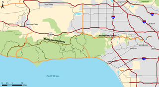
Mulholland Drive is a street and road in the eastern Santa Monica Mountains of Southern California. It is named after pioneering Los Angeles civil engineer William Mulholland. The western rural portion in Los Angeles and Ventura Counties is named Mulholland Highway. The road is featured in a significant number of movies, songs, and novels. David Lynch, who wrote and directed a film named after Mulholland Drive, has said that one can feel "the history of Hollywood" on it. Academy Award–winning actor Jack Nicholson has resided at Mulholland Drive for many years and still lives there today.
Route 710, consisting of the non-contiguous segments of State Route 710 (SR 710) and Interstate 710 (I-710), is a major north–south state highway and auxiliary Interstate Highway in the Los Angeles metropolitan area of the U.S. state of California. Also called the Los Angeles River Freeway prior to November 18, 1954, the highway was initially planned to connect Long Beach and Pasadena, but a gap in the route exists from Alhambra to Pasadena through South Pasadena due to community opposition to its construction.

The Ventura Freeway is a freeway in southern California, United States, running from the Santa Barbara/Ventura county line to Pasadena in Los Angeles County. It is the principal east-west route through Ventura County and in the southern San Fernando Valley in Los Angeles County. From the Santa Barbara County line to its intersection with the Hollywood Freeway in the southeastern San Fernando Valley in Los Angeles, it is signed as U.S. Route 101 (US 101), which was built in the late 1950s and opened on April 5, 1960. East of the Hollywood Freeway intersection, it is signed as State Route 134 (SR 134) which was built by 1971.

Lincoln Heights is one of the oldest neighborhoods in Los Angeles, California, United States. It was originally called "East Los Angeles" from 1873 to 1917. It is a densely populated, mostly Latino and Asian neighborhood. It includes many historic landmarks and was known as "the Bedroom of the Pueblo".
State Route 2 (SR 2) is a state highway in Los Angeles County and San Bernardino County, California. It connects the Los Angeles Basin with the San Gabriel Mountains and the Victor Valley in the Mojave Desert. The highway's western end is at the intersection of Centinela Avenue at the Santa Monica-Los Angeles border and its eastern end is at SR 138 east of Wrightwood. The SR 2 is divided into four segments, and it briefly runs concurrently with U.S. Route 101 (US 101) and Interstate 210 (I-210). The western section of the highway runs along a segment of Santa Monica Boulevard, an old routing of US 66, to US 101 in East Hollywood; the second section runs along segments of Alvarado Street and Glendale Boulevard in Echo Park; the third section to I-210 in Glendale is known as the Glendale Freeway; and the eastern portion from I-210 in La Cañada Flintridge to SR 138 is designated as the Angeles Crest Highway.

Colorado Boulevard is a major east–west street in Southern California. It runs from Griffith Park in Los Angeles east through Glendale, the Eagle Rock section of Los Angeles, Pasadena, and Arcadia, ending in Monrovia. The full route was once various state highways but is now locally maintained in favor of the parallel Ventura Freeway and Foothill Freeway (I-210).
State Route 118 is a state highway in the U.S. state of California that runs west to east through Ventura and Los Angeles counties. It travels from State Route 126 at the eastern edge of Ventura immediately northwest of Saticoy, then through Saticoy, in Ventura County east to Interstate 210 near Lake View Terrace in Los Angeles. SR 118 crosses the Santa Susana Pass and the northern rim of the San Fernando Valley along its route.

El Sereno is a Los Angeles neighborhood in the Eastside Los Angeles region of Los Angeles County, California.

Laurel Canyon Boulevard is a major street in the city of Los Angeles. It starts off at Polk Street in Sylmar in the northern San Fernando Valley near the junction of the San Diego and the Golden State (I-5)) freeways. Laurel Canyon Boulevard bypasses the city of San Fernando to the west, running parallel to I-5 in the vicinity of Pacoima and Arleta. The portion through Sun Valley passes through rock quarries and a great deal of open space.

Vermont Avenue is one of the longest running north–south streets in City of Los Angeles and Los Angeles County, California. With a length of 23.3 miles (37.5 km), is the third longest of the north–south thoroughfares in the region. For most of its length between its southern end in San Pedro and south of Downtown Los Angeles, it runs parallel to the west of the Harbor Freeway (I-110).

San Fernando Road is a major street in the City of Los Angeles and Los Angeles County. Within the Burbank city limits it is signed as San Fernando Boulevard, and north of Newhall Pass it is signed as The Old Road. It was previously designated as Business Loop 5 in the 1970s.
Foothill Boulevard is a major road in the city and county of Los Angeles, as well as an arterial road in the city and county of San Bernardino, stretching well over 60 miles (97 km) in length, with some notable breaks along the route. Like its name implies, Foothill Boulevard runs across the foothills of the San Gabriel and San Bernardino Mountains.
Valley Boulevard is a street in Southern California, running east from Los Angeles to Pomona, where it becomes Holt Boulevard, and a continuation from Fontana to Colton. It generally parallels Interstate 10 (I-10) and State Route 60 (CA 60), and is the original alignment of U.S. Route 60 (US 60). The present north end of I-710 is at Valley Boulevard in Los Angeles, just west of Alhambra.

Atlantic Boulevard/Atlantic Avenue/Los Robles Avenue is a major north–south thoroughfare in eastern Los Angeles County, California.

The Monrovia–Glendora Line was a route on the Pacific Electric Railway serving the San Gabriel Valley. It operated from 1902 to 1951, supporting nearby real estate development.
Soto Street is a major north-south thoroughfare in Los Angeles, California, connecting the southernmost neighborhoods of the Eastside, as well as the southeastern suburbs of Vernon and Huntington Park.
Wayne Gretzky Drive is a freeway in Edmonton, Alberta. Originally Capilano Drive/Capilano Freeway, it was officially renamed October 1, 1999, after NHL hockey player Wayne Gretzky, as a tribute to his years with the Edmonton Oilers. The same day, Wayne Gretzky's number 99 jersey was retired at the Skyreach Centre, which lies just west of Wayne Gretzky Drive, at 118 Avenue. 66/75 Street is a major arterial road in east Edmonton which serves residential and industrial areas.

Cesar Chavez Avenue is a major east–west thoroughfare in Downtown Los Angeles, the Eastside and East Los Angeles, measuring 6.19 miles (9.96 km) in length. Named in honor of union leader César Chávez, the street was formed in 1994 from Sunset Boulevard between Figueroa and Main streets, a new portion of roadway, Macy Street between Main Street and Mission Road, and Brooklyn Avenue through Boyle Heights and East Los Angeles into Monterey Park. Much of the street is double-signed with its former names.
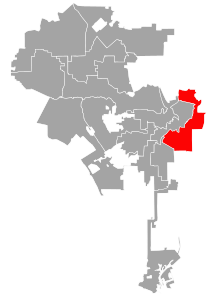
Los Angeles City Council District 14 is one of the 15 districts of the Los Angeles City Council. The district, which has a large Latin American population, includes the neighborhoods of Boyle Heights, Downtown Los Angeles and parts of Northeast Los Angeles. Councilman Kevin de León has represented the district since 2020. He replaced José Huizar after winning outright in the special election held during the 2020 California primaries; he was officially appointed on October 15, 2020. Huizar had vacated the seat earlier in the year due to bribery and corruption allegations.

Huntington Drive is a major thoroughfare that begins in the Rose Hills community in Los Angeles, California and heads east/northeast to Irwindale, California. The street was named after railroad magnate Henry Huntington. It also served as one of the only thoroughfares between Los Angeles and Pasadena in the early 1900s. Portions of Huntington Drive were part of U.S. Route 66. The road has a wide median that was originally one of the lines of the Pacific Electric Railway.

