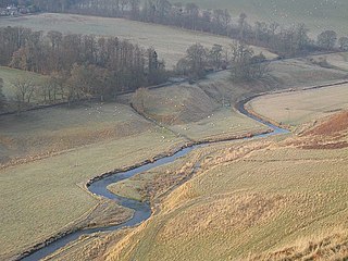
Leithen Water (Scottish Gaelic: Leitheann / Abhainn Leitheinn) is a tributary of the River Tweed in Scotland. It rises in the Moorfoot Hills and joins the Tweed near the town of Innerleithen, whose name comes from the Scottish Gaelicinbhir, meaning a confluence, and anglicised as "inner" or "inver". The Brythonic equivalent is "Aber". "Leithen" is a Celtic name meaning grey in colour (c.f. Welsh llwydion).
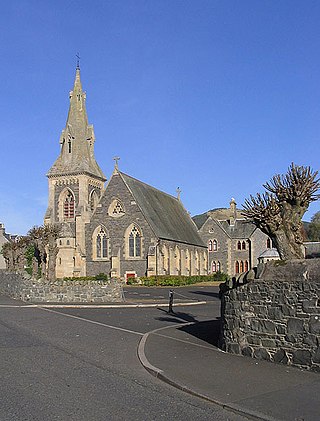
In Innerleithen the river is about 6–7 metres across and is not deep enough to swim. Leithen Water is a local favourite for the children who wade, 'guddle' fish (catch fish with hands) and play about in it. In the summer months, local children build small dams to deepen it, especially at the Cauld (a fish ladder near Innerleithen Golf Course) and at Leithen Bridge. The latter is an old stone bridge, erected in 1799 using funds from a stipend, to enable easy access for townsfolk to attend church on the west side of the Leithen Water.
Leithen Water is usually cool and clear, however post heavy rain it can become quite murky.
The Scottish Borders is one of 32 council areas of Scotland. It is bordered by West Lothian, Edinburgh, Midlothian, and East Lothian to the north, the North Sea to the east, Dumfries and Galloway to the south-west, South Lanarkshire to the west, and the English ceremonial counties of Cumbria and Northumberland to the south. The largest settlement is Galashiels, and the administrative centre is Newtown St Boswells.
Lothian is a region of the Scottish Lowlands, lying between the southern shore of the Firth of Forth and the Lammermuir Hills and the Moorfoot Hills. The principal settlement is the Scottish capital, Edinburgh, while other significant towns include Livingston, Linlithgow, Bathgate, Queensferry, Dalkeith, Bonnyrigg, Penicuik, Musselburgh, Prestonpans, Tranent, North Berwick, Dunbar, Whitburn and Haddington.
Innerleithen is a civil parish and a small town in the committee area of Tweeddale, in the Scottish Borders. It was formerly in the historic county of Peeblesshire or Tweeddale.
The River Tweed, or Tweed Water, Scots: Watter o Tweid, Welsh: Tuedd), is a river 97 miles (156 km) long that flows east across the Border region in Scotland and northern England. Tweed cloth derives its name from its association with the River Tweed. The Tweed is one of the great salmon rivers of Britain and the only river in England where an Environment Agency rod licence is not required for angling. The river generates a large income for the local borders region, attracting anglers from all around the world.
Peeblesshire, the County of Peebles or Tweeddale is a historic county of Scotland. Its county town is Peebles, and it borders Midlothian to the north, Selkirkshire to the east, Dumfriesshire to the south, and Lanarkshire to the west.
Tweeddale is a committee area and lieutenancy area in the Scottish Borders council area in south-eastern Scotland. It had also been a province in the Middle Ages. From 1975 to 1996 it was a local government district. Its boundaries correspond to the historic county of Peeblesshire.
The Gala Water is a river in the Scottish Borders area of Scotland and a tributary of the River Tweed. It is sometimes known as the "Gala", which nickname is also shared with Galashiels, which it flows through. The "Braw Lads O Gala Watter" is a song about people from Galashiels.
The River Garnock, the smallest of Ayrshire's six principal rivers, has its source on the southerly side of the Hill of Stake in the heart of the Clyde Muirshiel Regional Park. About a mile and a half south of this starting point the untested stream tumbles over the Spout of Garnock, the highest waterfall in Ayrshire, once thought to be the river's origin. The river then continues, for a total length of 20 miles (32 km) or so, through the towns of Kilbirnie, Glengarnock, Dalry and Kilwinning to its confluence with the River Irvine at Irvine Harbour.
Walkerburn is a small village in the Scottish Borders area of Scotland, on the A72 about 8 miles (13 km) from Peebles and 10 miles (16 km) from Galashiels.
The A72 road is a major route in Scotland connecting Hamilton in South Lanarkshire, with Galashiels in the Scottish Borders. It travels for over 97 kilometres (60 mi) in a south-easterly direction, along the Clyde and Tweed valleys, passing the towns of Larkhall, Lanark, Biggar and Peebles.
The Lyne Water is a tributary of the River Tweed that rises in the Pentland Hills of southern Scotland at Baddinsgill Reservoir. It runs through West Linton and Romannobridge, passes Flemington and Lyne Station and enters the Tweed west of Peebles. It floods regularly in winter and occasionally in summer. There is free fishing above Flemington Bridge, and below Flemington fishing in the river is administered by the Peebles fishing authority.
Leader Water is a small tributary of the River Tweed in Lauderdale in the Scottish Borders. It flows southwards from the Lammermuir Hills through the towns of Lauder and Earlston, joining the River Tweed at Leaderfoot.
Traquair is a small village and civil parish in the Scottish Borders; until 1975 it was in the county of Peeblesshire. The village is situated on the B709 road 2.0 miles (3.2 km) south of Innerleithen at grid reference NT330346.
Lyne is a small village and civil parish in the Scottish Borders area of Scotland, 4 miles (6.4 km) west of the market town of Peebles; it lies off the A72, in the old county of Peeblesshire and has an area of about 4 square miles (10 km2).
The Quair Water is a tributary of the River Tweed in the Scottish Borders area of Scotland. Its name is related to Traquair.
Burnfoot is a hamlet in the Scottish Borders area of Scotland, close to Roberton, by the Borthwick Water. The nearest town is Hawick to the east, and other places nearby include the Alemoor Loch, Branxholme, Broadhaugh, the Craik Forest. The meaning of Burnfoot is "Place at the foot of the burn".
Caddonfoot is a village on the River Tweed, in the Scottish Borders area of Scotland, on the A707, near Galashiels.
The Caddon Water is a small river by the village of Caddonfoot, in the Scottish Borders area of Scotland. It rises on Windlestraw Law, four miles north of Innerleithen, and flows through the Stantling Craig Reservoir. It joins the river Tweed at Caddonfoot, having completed its journey after 11 miles (18 km).
Cardrona is a village on the A72 and B7062, between Peebles and Innerleithen, in the Scottish Borders area of Scotland.
This page is based on this Wikipedia article Text is available under the CC BY-SA 4.0 license; additional terms may apply. Images, videos and audio are available under their respective licenses.