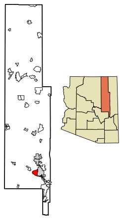
Show Low is a city in Navajo County, Arizona. It lies on the Mogollon Rim in east central Arizona, at an elevation of 6,345 feet. The city was established in 1870 and incorporated in 1953. According to the 2020 census, the population of the city was 11,732.

Navajo County is a county in the northern part of the U.S. state of Arizona. As of the 2020 census, its population was 106,717. The county seat is Holbrook.

Yavapai County is a county near the center of the U.S. state of Arizona. As of the 2020 census, its population was 236,209, making it the fourth-most populous county in Arizona. The county seat is Prescott.

McKinley County is a county in the northwestern section of the U.S. state of New Mexico. As of the 2020 United States Census, its population was 72,902. Its county seat is Gallup. The county was created in 1901 and named for President William McKinley.

Catron County is a county in the U.S. state of New Mexico. As of the 2020 census, the population was 3,579, making it New Mexico's third-least populous county. Its county seat is Reserve. Catron County is New Mexico's largest county by area.

Ganado is a chapter of the Navajo Nation and census-designated place (CDP) in Apache County, Arizona, United States. The population was 883 at the 2020 census, reduced from 1,210 at the 2010 census.
St. Johns is the county seat of Apache County, Arizona, United States. It is located along U.S. Route 180, mostly west of where that highway intersects with U.S. Route 191. As of the 2010 census, the population of the city was 3,480.

Heber-Overgaard is a census-designated place (CDP) in Navajo County, Arizona, United States. Situated atop the Mogollon Rim, the community lies at an elevation of 6,627 feet (2,020 m). The population was 2,898 at the 2020 census. Heber and Overgaard are technically two unincorporated communities, but as of the 1990 census, their proximity led to the merged name of "Heber-Overgaard".
Holbrook is a city in Navajo County, Arizona, United States. According to the 2010 census, the population of the city was 5,053. The city is the county seat of Navajo County.

Pueblo West is a census-designated place (CDP) in and governed by Pueblo County, Colorado, United States. The CDP is part of the Pueblo, CO Metropolitan Statistical Area. The population of the Pueblo West CDP was 33,086 according to the United States Census 2020. The Pueblo West Metropolitan District provides services. The Pueblo post office (Zip Code 81007) serves Pueblo West postal addresses.

The Fort Apache Indian Reservation is an Indian reservation in Arizona, United States, encompassing parts of Navajo, Gila, and Apache counties. It is home to the federally recognized White Mountain Apache Tribe of the Fort Apache Reservation, a Western Apache tribe. It has a land area of 1.6 million acres and a population of 12,429 people as of the 2000 census. The largest community is in Whiteriver.

Alpine is a census-designated place in Apache County, Arizona, United States, in Bush Valley in the east central part of the state. As of the 2010 census, it had a population of 145. It is located near the eastern border of the state.

Pinedale is an unincorporated community in Navajo County, Arizona, United States. The population was 487 at the 2010 census. The elevation is approximately 6,500 ft (2,000 m) and it is part of the Mogollon Rim mountain range.

Theba is an unincorporated community and census-designated place (CDP) in Maricopa County, Arizona, United States. Its elevation is 728 feet (222 m). Theba is located along Interstate 8 and is served by Exit 106. As of the 2020 census, it had a population of 111, down from 158 in 2010.

Vernon is an unincorporated community and census-designated place (CDP) in Apache County, Arizona, United States. As of the 2010 census it had a population of 122. Vernon is 19 miles (31 km) east of Show Low. Vernon has a post office with ZIP code 85940.

The Bureau of Indian Education (BIE), headquartered in the Main Interior Building in Washington, D.C., and formerly known as the Office of Indian Education Programs (OIEP), is a division of the U.S. Department of the Interior under the Assistant Secretary for Indian Affairs. It is responsible for the line direction and management of all BIE education functions, including the formation of policies and procedures, the supervision of all program activities, and the approval of the expenditure of funds appropriated for BIE education functions.
Bailey Ruin is an archaeological site located in Navajo County, Arizona, United States. The site, also known as "Stott Ranch Ruin" and "Pope Ranch Site," was added to the National Register of Historic Places on March 17, 2006 for its historical and archaeological significance.
Wide Ruins is a chapter of the Navajo Nation and a census-designated place (CDP) in Apache County, Arizona, United States. The population was 176 at the 2010 census.
Prewitt is an unincorporated community and census-designated place in McKinley County, New Mexico, United States. Prewitt is located along Interstate 40, 18 miles (29 km) northwest of Grants. Prewitt has a post office with ZIP code 87045.

Haigler Creek is an unincorporated community and census-designated place (CDP) in northern Gila County, Arizona, United States. It lies at an elevation of 5,240 feet and is surrounded by the Tonto National Forest. As of the 2020 census, Haigler Creek had a population of 39 people.