Lake of the Woods, Arizona

Last updated

Lake of the Woods, Arizona
CDP
USA Arizona location map.svg
Red pog.svg
Lake of the Woods
Location within the state of Arizona
Usa edcp location map.svg
Red pog.svg
Lake of the Woods
Lake of the Woods (the United States)
Coordinates: 34°09′17″N109°59′37″W / 34.15472°N 109.99361°W / 34.15472; -109.99361
CountryUnited States
State Arizona
County Navajo
Area
[1]
  Total4.14 sq mi (10.73 km2)
  Land3.96 sq mi (10.27 km2)
  Water0.18 sq mi (0.46 km2)
Elevation
[2]
6,785 ft (2,068 m)
Population
 (2020)
  Total3,648
  Density920.05/sq mi (355.20/km2)
Time zone UTC-7 (MST)
Area code 928
FIPS code 04-39790
GNIS feature ID2582812

Lake of the Woods is a census-designated place (CDP) in Navajo County, Arizona, United States, adjacent to the town of Pinetop-Lakeside. The population was 4,094 at the 2010 census.

Contents

Geography

Drysdale is located at 34°09′17″N109°59′37″W / 34.15472°N 109.99361°W / 34.15472; -109.99361 (34.154761, −109.993637). According to the United States Geological Survey, the CDP has a total area of 4.14 square miles (10.7 km2), consisting of 3.96 square miles (10.3 km2) of land and 0.18 square miles (0.47 km2) of water. [2] [3]

Demographics

Historical population
CensusPop.Note
2020 3,648
U.S. Decennial Census [4]

As of the 2010 census, there were 4,094 people living in the CDP: 2,078 male and 2,016 female. 1,185 were 19 years old or younger, 610 were ages 20–34, 744 were between the ages of 35 and 49, 907 were between 50 and 64, and the remaining 648 were aged 65 and above. The median age was 41.4 years.

The racial makeup of the CDP was 86.1% White, 2.4% American Indian, 0.7% Asian, 0.6% Black or African American, 7.6% Other, and 2.5% two or more races. 19.6% of the population were Hispanic or Latino of any race.

There were 1,607 households in the CDP, 1,093 family households (68.0%) and 514 non-family households (32.0%), with an average household size of 2.54. Of the family households, 815 were married couples living together, while 91 were single fathers and 187 were single mothers; the non-family households included 418 adults living alone: 221 male and 197 female.

The CDP contained 2,859 housing units, of which 1,607 were occupied and 1,252 were vacant. [5]

Related Research Articles

<span class="mw-page-title-main">Kaibito, Arizona</span> CDP in Coconino County, Arizona

Kaibeto is a census-designated place (CDP) in Coconino County, Arizona, United States. The population was 1,522 at the 2010 census.

<span class="mw-page-title-main">Parks, Arizona</span> CDP in Coconino County, Arizona

Parks is a census-designated place (CDP) in Coconino County, Arizona, United States. The population was 1,188 at the 2010 census.

<span class="mw-page-title-main">Desert Hills, Arizona</span> CDP in Mohave County, Arizona

Desert Hills is an unincorporated community and census-designated place (CDP) in Mohave County, Arizona, United States. The population was 2,764 at the 2020 census, up from 2,245 at the 2010 census.

<span class="mw-page-title-main">Greasewood, Arizona</span> CDP in Navajo County, Arizona

Greasewood is a census-designated place (CDP) in Navajo County, Arizona, United States. The population was 547 at the 2010 census.

<span class="mw-page-title-main">Myrtletown, California</span> Census designated place in California, United States

Myrtletown is a census-designated place (CDP) in Humboldt County, California, United States. Myrtletown lies at an elevation of 112 feet. Myrtletown is a part of the Eureka, California metropolitan area. The population was 4,675 at the 2010 census, up from 4,459 at the 2000 census.

<span class="mw-page-title-main">Twin Lakes, California</span> Census-designated place in California, United States

Twin Lakes is a census-designated place (CDP) in Santa Cruz County, California, United States. The population is at an estimated 5,378 as of 2016 which is up by 461 in 2010.

<span class="mw-page-title-main">Pine Lakes, Florida</span> Census-designated place in Florida

Pine Lakes is an unincorporated community and census-designated place (CDP) in Lake County, Florida, United States. The population was 862 at the 2010 census, up from 755 at the 2000 census. It is part of the Orlando–Kissimmee Metropolitan Statistical Area.

<span class="mw-page-title-main">Lake of the Woods, Illinois</span> Census-designated place in Illinois, United States

Lake of the Woods is a census-designated place in Champaign County, Illinois, United States. The population was 2,403 at the 2020 census. Lake of the Woods is located in Mahomet Township and mostly surrounded by the northeast part of the village of Mahomet.

<span class="mw-page-title-main">Country Lake Estates, New Jersey</span> Populated place in Burlington County, New Jersey, US

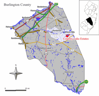
Country Lake Estates is an unincorporated community and census-designated place (CDP) located within Pemberton Township, in Burlington County, in the U.S. state of New Jersey. As of the 2010 United States Census, the CDP's population was 3,943.

Plain View is a census-designated place (CDP) in Sampson County, North Carolina, United States. The population was 1,923 at the 2020 U.S. census.

<span class="mw-page-title-main">Aneth, Utah</span> CDP in Utah, United States

Aneth is a census-designated place (CDP) in San Juan County, Utah, United States. The population was 598 at the 2000 census. The origin of the name Aneth is obscure.

<span class="mw-page-title-main">High Bridge, Washington</span> CDP in Washington, United States

High Bridge is a census-designated place (CDP) in Snohomish County, Washington, United States. The population was 2,994 at the 2010 census. High Bridge includes the Echo Lake community and the former Echo Lake CDP, which was superseded by the larger High Bridge CDP in 2010.

<span class="mw-page-title-main">Three Lakes, Washington</span> CDP in Washington, United States

Three Lakes is a census-designated place (CDP) in Snohomish County, Washington, United States. The population was 3,184 at the 2010 census.

Blairstown is an unincorporated community and census-designated place (CDP) located within Blairstown Township, in Warren County, in the U.S. state of New Jersey. The CDP was created as part of the 2010 United States census. As of the 2010 United States census, the CDP's population was 515.

Buckshot is a census-designated place (CDP) in Yuma County, Arizona, United States. The population was 153 at the 2010 census.

Hondah is a census-designated place (CDP) in Navajo County, Arizona, United States, on the Fort Apache Indian Reservation. The population was 812 at the 2010 census.

Low Mountain is a census-designated place (CDP) in Navajo County, Arizona, United States. The population was 757 at the 2010 census.

Martinez Lake is a census-designated place (CDP) in Yuma County, Arizona, United States, located on Martinez Lake. The population was 798 at the 2010 census. It was founded in 1958 as a fishing community. It remains primarily a vacation community.

North Fork is a census-designated place (CDP) in Navajo County, Arizona, United States, on the Fort Apache Indian Reservation. The population was 1,417 at the 2010 census.

Pinetop Country Club is a census-designated place (CDP) located in Navajo County, Arizona, United States. The population was 1,794 at the 2010 census.

References

  1. "2020 U.S. Gazetteer Files". United States Census Bureau. Retrieved October 29, 2021.
  2. 1 2 "Feature Detail Report for: Lake of the Woods Census Designated Place". Geographic Names Information System . United States Geological Survey, United States Department of the Interior.
  3. "Lake of the Woods CDP, Arizona – Basic Facts". AZ Hometown Locator. Retrieved December 6, 2016.
  4. "Census of Population and Housing". Census.gov. Retrieved June 4, 2016.
  5. "American FactFinder: Lake of the Woods CDP, Arizona". United States Census Bureau. Archived from the original on February 13, 2020. Retrieved December 6, 2016.