The Puebloans or Pueblo peoples, are Native Americans in the Southwestern United States who share common agricultural, material, and religious practices. Pueblo, which means "village" in Spanish, was a term originating with the Colonial Spanish, who used it to refer to the people's particular style of dwelling.
The Hopi are a Native American tribe who primarily live on the Hopi Reservation in northeastern Arizona. As of the 2010 census, there are 19,338 Hopi in the United States. The Hopi Tribe is a sovereign nation within the United States and has government-to-government relations with the United States federal government. Particular villages retain autonomy under the Hopi Constitution and Bylaws. The Hopi language is one of 30 in the Uto-Aztecan language family. The majority of Hopi people are enrolled in the Hopi Tribe of Arizona but some are enrolled in the Colorado River Indian Tribes. The Hopi Reservation covers a land area of 2,531.773 sq mi (6,557.26 km2).

First Mesa is a census-designated place (CDP) in Navajo County, Arizona, United States, on the Hopi Reservation. As of the 2010 census, the CDP population was 1,555, spread among three Hopi villages atop the 5,700-foot mesa: Hano, Sitsomovi, and Waalpi.
Hopi is a Uto-Aztecan language spoken by the Hopi people of northeastern Arizona, United States.

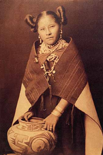
Nampeyo was a Hopi-Tewa potter who lived on the Hopi Reservation in Arizona. Her Tewa name was also spelled Num-pa-yu, meaning "snake that does not bite". Her name is also cited as "Nung-beh-yong," Tewa for Sand Snake.

Black Mesa is an upland mountainous mesa of Arizona, north-trending in Navajo County, west and southeast-trending in Apache County. In Navajo it is called Dziłíjiin and during Mexican rule of Arizona it was called Mesa de las Vacas. It derives its dark appearance from the numerous seams of coal that run through it.

Navajo National Monument is a National Monument located within the northwest portion of the Navajo Nation territory in northern Arizona, which was established to preserve three well-preserved cliff dwellings of the Ancestral Puebloan people: Keet Seel, Betatakin, and Inscription House. The monument is high on the Shonto plateau, overlooking the Tsegi Canyon system, west of Kayenta, Arizona. It features a visitor center with a museum, three short self-guided trails, two small campgrounds, and a picnic area.

The Hopi Reservation is a Native American reservation for the Hopi and Arizona Tewa people, surrounded entirely by the Navajo Nation, in Navajo and Coconino counties of Arizona, United States. The site in north-eastern Arizona has a land area of 2,531.773 sq mi (6,557.262 km²) and as of the 2000 census had a population of 6,946. The Hopi Reservation, like most of Arizona but unlike the surrounding Navajo Nation, does not observe daylight saving time. Until recently, the two nations shared the Navajo–Hopi Joint Use Area. The partition of this area, commonly known as Big Mountain, by Acts of Congress in 1974 and 1996, has resulted in continuing controversy. The system of villages unites three mesas in the pueblo style traditionally used by the Hopi. Walpi is the oldest village on First Mesa, having been established in 1690 after the villages at the foot of mesa Koechaptevela were abandoned for fear of Spanish reprisal after the 1680 Pueblo Revolt. The Tewa people live on First Mesa. Hopi also occupy the Second Mesa and Third Mesa. The community of Winslow West is off-reservation trust land of the Hopi tribe. The Hopi Tribal Council is the local governing body consisting of elected officials from the various reservation villages. Its powers were given to it under the Hopi Tribal Constitution. The Hopi consider their life on the reservation an integral and critically sustaining part of the "fourth world". Hopi High School is the secondary education institute for reservation residents. Hopi Radio, a station with a mix of traditional Hopi and typical American programming is run for the reservation and provides internships for Hopi High School.
The Hopi-Tewa are a Tewa Pueblo group that resides on the eastern part of the Hopi Reservation on or near First Mesa in northeastern Arizona.

Walpi,, is a Hopi village established around 900 AD. It is located above Arizona State Route 264, east of the Grand Canyon in Navajo County, northern Arizona. Walpi is the Hopi term for "place of the notch." Historically, the village has also been known as Ash Hill Terrace, Gaspe, Gualpi, Hualpi, Kuchapturela, Valpee, and Wolpi. Walpi became the official name as a result of a decision of the Board on Geographic Names in 1915.

The Dark Wind is the fifth crime fiction novel in the Joe Leaphorn / Jim Chee Navajo Tribal Police series by Tony Hillerman, published in 1982. It is the second of the novels to feature Officer Jim Chee.
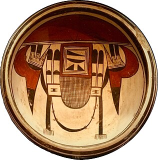
Fannie Nampeyo (1900–1987) was a modern and contemporary fine arts potter, who carried on the traditions of her famous mother, Nampeyo of Hano, the grand matriarch of modern Hopi pottery.

The term Navajo Pueblitos, also known as Dinétah Pueblitos, refers to a class of archaeological sites that are found in the northwestern corner of the American state of New Mexico. The sites generally consist of relatively small stone and timber structures which are believed to have been built by the Navajo people in the late 17th and early 18th centuries.
KUYI 88.1 FM, is a Native American Public Radio station in Keams Canyon, Arizona. The station, founded in 2000, primarily features locally produced programming for the Hopi, Tewa, and Navajo Native American tribal residents, surrounding communities in Northern Arizona, the Four Corners areas and streaming worldwide. Other network programming is provided by Native Voice One. Top of the hour news updates from National Public Radio are aired Monday through Friday. Its musical programming is a mix of traditional Hopi and modern music.
Polacca is an unincorporated community in Navajo County, of northeastern Arizona. It is Hopi-Tewa community on the Hopi Reservation.
Arizona, a state in the southwestern region of the United States of America, is known for its high population of Native Americans. Arizona has the third highest number of Native Americans of any state in the Union. Out of the entire US population of 2.9 million Native Americans, roughly 286,680 live in Arizona, representing 10% of the country's total Native American population. Only California and Oklahoma have more Native Americans than Arizona by number. Arizona also has the highest proportion of land allocated to Native American reservations, at 28%. Arizona has five of the twelve largest Indian reservations in the United States, including the largest, the Navajo Nation, and the third-largest, the Tohono O'odham Nation. Also, Arizona has the largest number of Native American language speakers in the United States.
Kawaika-A is a populated place situated in Navajo County, Arizona. It has an estimated elevation of 6,440 feet (1,960 m) above sea level.
Na Ah Tee, historically also known as Na-Ah-Tee Canyon, Na-a-tih Trading Post, and Na-at-tee Canyon, is a populated place situated in Navajo County, Arizona. It has an estimated elevation of 6,263 feet (1,909 m) above sea level.
Sipaulovi is a populated place situated on the Hopi Reservation within the Second Mesa CDP in Navajo County, Arizona. It has been known by numerous names over the years, including Ah-le-la, Ahela, Ci-pau-lo-vi, Sha-pah-la, Sha-pah-lah-lwee, Shi-pau-i-luvi, Shi-paui-i-luvi, Shipaulavi, Shipaulovi, Shipolia, and Shipowlawe. Historically, it has had two official names, both as a result of decisions by the Board on Geographic Names. In 1915, the Board officially named the settlement Shipolovi, but in 1988 they changed the official name to its current Sipaulovi. It was settled in approximately 1750 by settlers who were fleeing from a mosquito infestation. In Hopi sipaulovi refers to mosquitos. It has an estimated elevation of 6,312 feet (1,924 m) above sea level.

The indigenous peoples of the North American Southwest are those in the current states of Colorado, Arizona, New Mexico, Utah, and Nevada in the western United States, and the states of Sonora and Chihuahua in northern Mexico. An often quoted statement from Erik Reed (1964) defined the Greater Southwest culture area as extending north to south from Durango, Mexico to Durango, Colorado and east to west from Las Vegas, Nevada to Las Vegas, New Mexico. Other names sometimes used to define the region include "American Southwest", "North Mexico", "Chichimeca", and "Oasisamerica/Aridoamerica". This region has long been occupied by hunter-gatherers and agricultural people.


